Elkhorn, Wisconsin
| Elkhorn, Wisconsin | |
|---|---|
| City | |
|
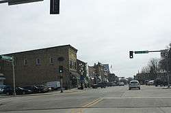
Looking south in downtown Elkhorn | |
 Location of Elkhorn, Wisconsin | |
| Coordinates: 42°40′22″N 88°32′25″W / 42.67278°N 88.54028°WCoordinates: 42°40′22″N 88°32′25″W / 42.67278°N 88.54028°W | |
| Country | United States |
| State | Wisconsin |
| County | Walworth |
| Area[1] | |
| • Total | 7.81 sq mi (20.23 km2) |
| • Land | 7.76 sq mi (20.10 km2) |
| • Water | 0.05 sq mi (0.13 km2) |
| Elevation[2] | 1,030 ft (314 m) |
| Population (2010)[3] | |
| • Total | 10,084 |
| • Estimate (2012[4]) | 10,082 |
| • Density | 1,299.5/sq mi (501.7/km2) |
| Time zone | Central (CST) (UTC-6) |
| • Summer (DST) | CDT (UTC-5) |
| Area code(s) | 262 |
| FIPS code | 55-23300[5] |
| GNIS feature ID | 1564532[2] |
| Website | www.cityofelkhorn.org |
Elkhorn is a city in Walworth County, Wisconsin, United States. It is southwest of Milwaukee and northwest of Chicago. The population was 10,084 at the 2010 census. It is the county seat.[6]
Geography
Elkhorn is located at 42°40′22″N 88°32′25″W / 42.67278°N 88.54028°W (42.672900, -88.540342).[7]
According to the United States Census Bureau, the city has a total area of 7.81 square miles (20.23 km2), of which 7.76 square miles (20.10 km2) is land and 0.05 square miles (0.13 km2) is water.[1]
History
In 1836, Colonel Samuel Phoenix spotted a rack of elk antlers in a tree and proclaimed the area as "Elk Horn."[8]
The area's beauty and fertile soil lead Daniel Bradley, his son Milo, and LeGrand Rockwell to create a community in the area. Its growth to a population of 539 led to the first town meeting in 1846. Elkhorn was designated county seat that same year because of its location in Walworth County.
In 1851, Elkhorn became the location of the Walworth County Fair, which is now hosted annually at the Walworth County Fairgrounds. The Walworth County Fair is the largest in Wisconsin after the Wisconsin State Fair,
Because the city places Christmas decorations around its center, Elkhorn has been called the "Christmas Card Town" since before World War II. This tradition is celebrated every year by an annual oil painting by local artist Jan Castle Reed. These watercolor paintings are turned into Christmas cards.[9]
Demographics
| Historical population | |||
|---|---|---|---|
| Census | Pop. | %± | |
| 1850 | 42 | — | |
| 1860 | 1,081 | 2,473.8% | |
| 1870 | 1,205 | 11.5% | |
| 1880 | 1,122 | −6.9% | |
| 1890 | 1,447 | 29.0% | |
| 1900 | 1,731 | 19.6% | |
| 1910 | 1,707 | −1.4% | |
| 1920 | 1,991 | 16.6% | |
| 1930 | 2,340 | 17.5% | |
| 1940 | 2,382 | 1.8% | |
| 1950 | 2,935 | 23.2% | |
| 1960 | 3,586 | 22.2% | |
| 1970 | 3,992 | 11.3% | |
| 1980 | 4,605 | 15.4% | |
| 1990 | 5,337 | 15.9% | |
| 2000 | 7,305 | 36.9% | |
| 2010 | 10,084 | 38.0% | |
| Est. 2015 | 9,895 | [10] | −1.9% |
2010 census
As of the census[3] of 2010, there were 10,084 people, 3,801 households, and 2,514 families residing in the city. The population density was 1,299.5 inhabitants per square mile (501.7/km2). There were 4,043 housing units at an average density of 521.0 per square mile (201.2/km2). The racial makeup of the city was 91.4% White, 1.2% African American, 0.2% Native American, 0.7% Asian, 4.8% from other races, and 1.6% from two or more races. Hispanic or Latino of any race were 11.0% of the population.
There were 3,801 households of which 38.8% had children under the age of 18 living with them, 48.7% were married couples living together, 12.5% had a female householder with no husband present, 4.9% had a male householder with no wife present, and 33.9% were non-families. 27.8% of all households were made up of individuals and 11% had someone living alone who was 65 years of age or older. The average household size was 2.53 and the average family size was 3.11.
The median age in the city was 34.3 years. 27.5% of residents were under the age of 18; 8.2% were between the ages of 18 and 24; 29.1% were from 25 to 44; 23.3% were from 45 to 64; and 11.9% were 65 years of age or older. The gender makeup of the city was 49.7% male and 50.3% female.
2000 census
As of the census[5] of 2000, there were 7,305 people, 2,919 households, and 1,903 families residing in the city. The population density was 1,005.2 people per square mile (388.0/km²). There were 3,014 housing units at an average density of 414.7 per square mile (160.1/km²). The racial makeup of the city was 94.81% White, 0.47% African American, 0.40% Native American, 0.55% Asian, 0.03% Pacific Islander, 2.83% from other races, and 0.92% from two or more races. Hispanic or Latino of any race were 6.13% of the population.
There were 2,919 households out of which 37.2% had children under the age of 18 living with them, 48.6% were married couples living together, 12.1% had a female householder with no husband present, and 34.8% were non-families. 28.5% of all households were made up of individuals and 11.2% had someone living alone who was 65 years of age or older. The average household size was 2.48 and the average family size was 3.07.
In the city the population was spread out with 28.0% under the age of 18, 8.7% from 18 to 24, 32.2% from 25 to 44, 18.3% from 45 to 64, and 12.8% who were 65 years of age or older. The median age was 34 years. For every 100 females there were 91.4 males. For every 100 females age 18 and over, there were 87.5 males.
The median income for a household in the city was $38,395, and the median income for a family was $47,475. Males had a median income of $34,867 versus $22,253 for females. The per capita income for the city was $20,003. About 7.4% of families and 9.9% of the population were below the poverty line, including 12.7% of those under age 18 and 10.1% of those age 65 or over.
Transportation
Elkhorn was a stop on the Racine & Southwestern branch line of the Chicago, Milwaukee, St. Paul and Pacific Railroad, better known as the Milwaukee Road. In its 1980 bankruptcy, the Milwaukee Road disposed of the Southwestern Line. The Wisconsin & Southern continues to service Elkhorn from a connection at Bardwell to the west.[12]
Notable people
- Lucius Allen - Wisconsin State Assembly
- Thomas Ryum Amlie - U.S. Representative
- Charles Coleman - Wisconsin State Assembly
- Ely B. Dewing - Wisconsin State Assembly
- Sidney Clayton Goff - Wisconsin State Assembly
- John Harris - Wisconsin State Senate
- William H. Hurlbut - Wisconsin State Assembly
- Greg Kent - NFL player
- Dave Kraayeveld - NFL player
- Jay G. Lamberson - Wisconsin State Assembly
- Hollis Latham - Wisconsin State Assembly
- Tallan Noble Latz - musician
- John Raleigh - MLB player
- Eldo T. Ridgway - Wisconsin State Senate, mayor of Elkhorn
- Jim Roslof - fantasy artist
- Patrick Smage - motorcycle racer
- James D. Swan - Wisconsin State Senate[13]
- Joseph Philbrick Webster - composer of In the Sweet By-and-By
- Scott Wedige - NFL player
Images
 Police department and Municipal Court
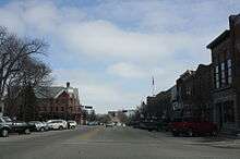
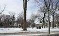 Park in town square
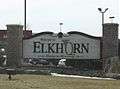 Welcome sign
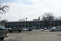
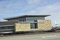 Mercy Elkhorn Medical Center
References
- 1 2 "US Gazetteer files 2010". United States Census Bureau. Retrieved 2012-11-18.
- 1 2 "US Board on Geographic Names". United States Geological Survey. 2007-10-25. Retrieved 2008-01-31.
- 1 2 "American FactFinder". United States Census Bureau. Retrieved 2012-11-18.
- ↑ "Population Estimates". United States Census Bureau. Retrieved 2013-06-24.
- 1 2 "American FactFinder". United States Census Bureau. Retrieved 2008-01-31.
- ↑ "Find a County". National Association of Counties. Retrieved 2011-06-07.
- ↑ "US Gazetteer files: 2010, 2000, and 1990". United States Census Bureau. 2011-02-12. Retrieved 2011-04-23.
- ↑ Henry Gannett (1905). The Origin of Certain Place Names in the United States. Govt. Print. Off. p. 117.
- ↑ http://cityofelkhorn.org/Community/History.htm
- ↑ "Annual Estimates of the Resident Population for Incorporated Places: April 1, 2010 to July 1, 2015". Retrieved July 2, 2016.
- ↑ "Census of Population and Housing". Census.gov. Retrieved June 4, 2015.
- ↑ Elkhorn Railroad History and Photos
- ↑ Wisconsin Blue Book 1973, p. 50
External links
| Wikimedia Commons has media related to Elkhorn, Wisconsin. |
- City of Elkhorn, Wisconsin website
- Elkhorn Chamber of Commerce website
- Sanborn fire insurance maps: 1893 1898 1904 1911
Municipalities and communities of Walworth County, Wisconsin, United States | ||
|---|---|---|
| Cities | 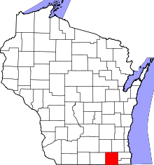 | |
| Villages | ||
| Towns | ||
| CDPs | ||
| Unincorporated communities |
| |
| Ghost towns | ||
| Footnotes | ‡This populated place also has portions in an adjacent county or counties | |