Ellerslie, Maryland
| Ellerslie, Maryland | |
|---|---|
| Census-designated place | |
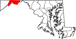
 Ellerslie  Ellerslie Location within the state of Maryland | |
| Coordinates: 39°43′13″N 78°46′26″W / 39.72028°N 78.77389°WCoordinates: 39°43′13″N 78°46′26″W / 39.72028°N 78.77389°W | |
| Country | United States |
| State | Maryland |
| County | Allegany |
| Area | |
| • Total | 0.4 sq mi (1.0 km2) |
| • Land | 0.4 sq mi (1.0 km2) |
| • Water | 0 sq mi (0 km2) |
| Elevation | 733 ft (223 m) |
| Population (2010) | |
| • Total | 572 |
| • Density | 1,505/sq mi (581.0/km2) |
| Time zone | Eastern (EST) (UTC-5) |
| • Summer (DST) | EDT (UTC-4) |
| ZIP codes | 21529 |
| Area code(s) | 301 |
| FIPS code | 24-25925 |
| GNIS feature ID | 2583613 |
Ellerslie is an unincorporated community and census-designated place (CDP) in Allegany County, Maryland, United States. As of the 2010 census it had a population of 572.[1] Ellerslie is part of the Cumberland, MD-WV Metropolitan Statistical Area.
The town lies along Maryland Route 35, 7 miles (11 km) north of Cumberland next to the Pennsylvania-Maryland state line. To the north, Pennsylvania Route 96 extends 8 miles (13 km) to Hyndman, Pennsylvania and 31 miles (50 km) to Bedford, Pennsylvania. Ellerslie is situated in the valley of Wills Creek, between the parallel ridges of Little Allegheny Mountain to the west and Wills Mountain to the east.
References
- ↑ "Geographic Identifiers: 2010 Demographic Profile Data (G001): Ellerslie CDP, Maryland". U.S. Census Bureau, American Factfinder. Retrieved May 24, 2013.
External links
This article is issued from Wikipedia - version of the 10/29/2016. The text is available under the Creative Commons Attribution/Share Alike but additional terms may apply for the media files.