Emery, North Carolina
| Emery, North Carolina | |
|---|---|
| Populated place | |
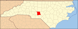 Map of Montgomery County, North Carolina, in which Emery is located | |
| Coordinates: 35°14′51″N 79°43′21″W / 35.24750°N 79.72250°WCoordinates: 35°14′51″N 79°43′21″W / 35.24750°N 79.72250°W | |
| Country | United States[1] |
| State | North Carolina[1] |
| County | Montgomery[1] |
| Elevation[1][2] | 682 ft (208 m) |
| Time zone | Eastern (EST) (UTC-5) |
| • Summer (DST) | EDT (UTC-4) |
| ZIP code | 27281[1][2] |
| Area code(s) | 910 |
| Census Code & Class | 21210; U6[1][2] |
| GNIS feature ID | 1020150[1] |
Emery, North Carolina is a populated place[2] in Montgomery County, North Carolina, in the United States.[1] It is located along the co-designated Interstate 73 - Interstate 74, about 50 miles south of Greensboro where the interstates meet U.S. Route 220. It is approximately equidistant between Raleigh to the east and Charlotte to the west. Its ZIP code is 27281.[1][2] Its elevation is 682 feet above mean sea level.[2]
Emery itself is not considered a city, town, or village. It is not covered by the United States Census; The nearest census-designated place (CDP) is Candor, located four miles to the north.
External links
- Emery, North Carolina via Google Maps
- Community profile from HomeTownLocator
- Photos of Emery from Panoramio
References
- 1 2 3 4 5 6 7 8 9 "US Board on Geographic Names". Washington, DC: United States Geological Survey. 2007-10-25. Retrieved 2009-06-27.
- 1 2 3 4 5 6 Community profile from HomeTownLocator
Municipalities and communities of Montgomery County, North Carolina, United States | ||
|---|---|---|
| Towns | | |
| Unincorporated communities | ||
This article is issued from Wikipedia - version of the 11/8/2016. The text is available under the Creative Commons Attribution/Share Alike but additional terms may apply for the media files.