Ena, Gifu
| Ena 恵那市 | ||
|---|---|---|
| City | ||
|
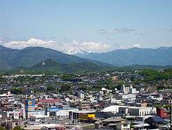
View of central Ena, Ena Valley Amusement Park and Mount Ontake | ||
| ||
 Location of Ena in Gifu Prefecture | ||
 Ena Location in Japan | ||
| Coordinates: 35°27′N 137°25′E / 35.450°N 137.417°ECoordinates: 35°27′N 137°25′E / 35.450°N 137.417°E | ||
| Country | Japan | |
| Region | Chūbu | |
| Prefecture | Gifu Prefecture | |
| Government | ||
| • Mayor | Yoshiaki Kachi | |
| Area | ||
| • Total | 504.19 km2 (194.67 sq mi) | |
| Population (July 2011[1]) | ||
| • Total | 53,378 | |
| • Density | 110/km2 (270/sq mi) | |
| Symbols | ||
| • Tree | Red Maple | |
| • Flower | Sasayuri | |
| Time zone | Japan Standard Time (UTC+9) | |
| City hall address |
1-1-1 Shōge, Osashima-chō, Ena-shi, Gifu-ken 509-7292 | |
| Website |
www | |

Ena City (恵那市 Ena-shi) is a city located in the Tōnō region of Gifu Prefecture, Japan.
As of July 2011, the city has an estimated population of 53,378 and a population density of 110 persons per km². The total area is 504.19 km².
The city was founded on April 1, 1954. On October 25, 2004, Ena absorbed the towns of Akechi, Iwamura, Kamiyahagi and Yamaoka, and the village of Kushihara (all from Ena District) to create the expanded city of Ena.
Geography
- Mountains: Mount Kasagi, Mount Hoko, Mount Yūdachi, Mount Byōbu, Mount Yake, Mount Mitsumori
- Rivers: Kiso River, Agi River, Kamiyahagi River, Kamimura River, Akechi River, Toki River, Ori River
- Lakes: Ena Gorge, Lake Hokonoko, Lake Agigawa, Lake Okuyahagi, Lake Origawa
Areas
- Ōi-chō (大井町)
- Osashima-chō (長島町)
- Takenami-chō (武並町)
- Misato-chō (三郷町)
- Kasagi-chō (笠置町)
- Iiji-chō (飯地町)
- Nakanohō-chō (中野方町)
- Higashino (東野)
- Iwamura-chō (岩村町)
- Yamaoka-chō (山岡町)
- Akechi-chō (明智町)
- Kamiyahagi-chō (上矢作町)
- Kushihara (串原)
Education
- Gifu Prefectural Ena High School
- Gifu Prefectural Ena Agricultural High School
- Gifu Prefectural Ena-Minami High School
Transportation
Railway
- Chūō Main Line (JR Central): Takenami Station - Ena Station
- Akechi Railway (Akechi Line): Ena Station - Higashino Station - Iinuma Station (Nakatsugawa, Gifu) - Agi Station (Nakatsugawa) - Iibama Station - Gokuraku Station - Iwamura Station - Hanashiro Station - Yamaoka Station - Noshi Station - Akechi Station
Roads
Expressway
- Chūō Expressway: Ena Interchange - Enakyō Service Area
National routes
Public facilities
Hospitals and clinics
- Ena Municipal Hospital
- Kamiyahagi Hospital
Other
- Ena Police Station
- Gifu Prefectural Ena General Office
Notable people from Ena
- Kiyohiro Araki (member of the House of Councilors)
- Utako Shimoda (founder of Jissen Women's Educational Institute)
Historic and sightseeing locations
- Nakasendō Ōi-juku
- Hiroshige Museum of Art, Ena
- Ena Gorge
- Japan Water Agency Agigawa Dam
- Iwamura Castle Ruins
- Nihon Taishō Mura
- Sasayuri no Yu
- Yahagi Dam
- Mongol Village
References
- ↑ 岐阜県の人口・世帯数人口動態統計調査結果. Gifu prefectural website (in Japanese). Gifu Prefecture. Retrieved September 11, 2011.
External links
| Wikimedia Commons has media related to Ena, Gifu. |
- Ena City official website (Japanese)
| Core city | ||
|---|---|---|
| Cities | ||
| Anpachi District | ||
| Fuwa District | ||
| Hashima District | ||
| Ibi District | ||
| Kamo District | ||
| Kani District | ||
| Motosu District | ||
| Ōno District | ||
| Yōrō District | ||
This article is issued from Wikipedia - version of the 11/19/2016. The text is available under the Creative Commons Attribution/Share Alike but additional terms may apply for the media files.