Esbon, Kansas
| Esbon, Kansas | |
|---|---|
| City | |
 Location within Jewell County and Kansas | |
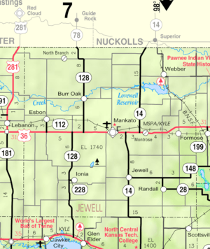 KDOT map of Jewell County (legend) | |
| Coordinates: 39°49′22″N 98°26′2″W / 39.82278°N 98.43389°WCoordinates: 39°49′22″N 98°26′2″W / 39.82278°N 98.43389°W | |
| Country | United States |
| State | Kansas |
| County | Jewell |
| Area[1] | |
| • Total | 0.31 sq mi (0.80 km2) |
| • Land | 0.31 sq mi (0.80 km2) |
| • Water | 0 sq mi (0 km2) |
| Elevation | 1,844 ft (562 m) |
| Population (2010)[2] | |
| • Total | 99 |
| • Estimate (2012[3]) | 98 |
| • Density | 320/sq mi (120/km2) |
| Time zone | Central (CST) (UTC-6) |
| • Summer (DST) | CDT (UTC-5) |
| ZIP code | 66941 |
| Area code | 785 |
| FIPS code | 20-21600 [4] |
| GNIS feature ID | 0471981 [5] |
| Website | City Website |
Esbon is a city in Jewell County, Kansas, United States. As of the 2010 census, the city population was 99.[6]
History
Esbon was laid out in 1873.[7] It was incorporated as a city in 1904.[8]
The first post office in Esbon was established in January 1874.[9]
Esbon was a shipping point on the Chicago, Rock Island and Pacific Railroad.[8]
Geography
Esbon is located at 39°49′22″N 98°26′2″W / 39.82278°N 98.43389°W (39.822656, -98.433762).[10] According to the United States Census Bureau, the city has a total area of 0.31 square miles (0.80 km2), all of it land.[1]
The town lies 2.5 miles north of U.S. Route 36, and 13 miles west of Mankato, the county seat of Jewell County.
Demographics
| Historical population | |||
|---|---|---|---|
| Census | Pop. | %± | |
| 1910 | 347 | — | |
| 1920 | 375 | 8.1% | |
| 1930 | 319 | −14.9% | |
| 1940 | 292 | −8.5% | |
| 1950 | 278 | −4.8% | |
| 1960 | 237 | −14.7% | |
| 1970 | 206 | −13.1% | |
| 1980 | 234 | 13.6% | |
| 1990 | 167 | −28.6% | |
| 2000 | 148 | −11.4% | |
| 2010 | 99 | −33.1% | |
| Est. 2015 | 96 | [11] | −3.0% |
| U.S. Decennial Census | |||
The town has a Roman Catholic church, Sacred Heart, and also has a United Methodist Church.
2010 census
As of the census[2] of 2010, there were 99 people, 52 households, and 24 families residing in the city. The population density was 319.4 inhabitants per square mile (123.3/km2). There were 84 housing units at an average density of 271.0 per square mile (104.6/km2). The racial makeup of the city was 91.9% White, 1.0% African American, 3.0% Native American, and 4.0% from two or more races. Hispanic or Latino of any race were 1.0% of the population.
There were 52 households of which 19.2% had children under the age of 18 living with them, 38.5% were married couples living together, 1.9% had a female householder with no husband present, 5.8% had a male householder with no wife present, and 53.8% were non-families. 48.1% of all households were made up of individuals and 21.2% had someone living alone who was 65 years of age or older. The average household size was 1.90 and the average family size was 2.67.
The median age in the city was 52.3 years. 19.2% of residents were under the age of 18; 4.1% were between the ages of 18 and 24; 18.2% were from 25 to 44; 28.4% were from 45 to 64; and 30.3% were 65 years of age or older. The gender makeup of the city was 54.5% male and 45.5% female.
2000 census
As of the census[4] of 2000, there were 148 people, 71 households, and 37 families residing in the city. The population density was 484.8 people per square mile (184.3/km²). There were 87 housing units at an average density of 285.0 per square mile (108.4/km²). The racial makeup of the city was 96.62% White and 3.38% Native American.
There were 71 households out of which 19.7% had children under the age of 18 living with them, 46.5% were married couples living together, 7.0% had a female householder with no husband present, and 46.5% were non-families. 45.1% of all households were made up of individuals and 23.9% had someone living alone who was 65 years of age or older. The average household size was 2.08 and the average family size was 3.00.
In the city the population was spread out with 23.0% under the age of 18, 4.7% from 18 to 24, 25.7% from 25 to 44, 20.3% from 45 to 64, and 26.4% who were 65 years of age or older. The median age was 44 years. For every 100 females there were 87.3 males. For every 100 females age 18 and over, there were 103.6 males.
The median income for a household in the city was $26,875, and the median income for a family was $34,167. Males had a median income of $24,688 versus $13,125 for females. The per capita income for the city was $17,438. There were none of the families and 6.7% of the population living below the poverty line, including no under eighteens and 16.7% of those over 64.
Economy
The primary business enterprise of the town is a grain elevator at the north end of Grand Avenue. Farming is the principal occupation in the area around Esbon.
Education
The town had an elementary school and high school until about 1985, and it was the home of White Rock Middle school, at 203 Grand Ave, serving 32 students enrolled 2008 in the 6th through 8th grades.[12] The nearest schools for other grades had been an elementary school and a high school in Burr Oak. The schools now consolidated in Mankato Kansas the county seat.
References
- 1 2 "US Gazetteer files 2010". United States Census Bureau. Retrieved 2012-07-06.
- 1 2 "American FactFinder". United States Census Bureau. Retrieved 2012-07-06.
- ↑ "Population Estimates". United States Census Bureau. Retrieved 2013-05-29.
- 1 2 "American FactFinder". United States Census Bureau. Retrieved 2008-01-31.
- ↑ "US Board on Geographic Names". United States Geological Survey. 2007-10-25. Retrieved 2008-01-31.
- ↑ "2010 City Population and Housing Occupancy Status". U.S. Census Bureau. Retrieved March 6, 2011.
- ↑ Kansas State Historical Society (1916). Biennial Report of the Board of Directors of the Kansas State Historical Society. Kansas State Printing Plant. p. 211.
- 1 2 Blackmar, Frank Wilson (1912). Kansas: A Cyclopedia of State History, Embracing Events, Institutions, Industries, Counties, Cities, Towns, Prominent Persons, Etc. Standard Publishing Company. p. 597.
- ↑ "Kansas Post Offices, 1828-1961". Kansas Historical Society. Retrieved 11 June 2014.
- ↑ "US Gazetteer files: 2010, 2000, and 1990". United States Census Bureau. 2011-02-12. Retrieved 2011-04-23.
- ↑ "Annual Estimates of the Resident Population for Incorporated Places: April 1, 2010 to July 1, 2015". Retrieved July 2, 2016.
- ↑ EducationBug.org "Jewell County, Kansas Public Schools". Retrieved on 2008-02-14.
External links
| Wikimedia Commons has media related to Esbon, Kansas. |
- City
- Schools
- USD 107, local school district
- Maps
- Esbon City Map, KDOT
Municipalities and communities of Jewell County, Kansas, United States | ||
|---|---|---|
| Cities | 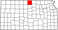 | |
| Unincorporated communities | ||
| Townships | ||