Estherton, Pennsylvania
| Estherton, Pennsylvania | |
|---|---|
| Unincorporated area | |
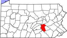
 Estherton Location within the state of Pennsylvania | |
| Coordinates: 40°18′44″N 76°53′52″W / 40.31222°N 76.89778°WCoordinates: 40°18′44″N 76°53′52″W / 40.31222°N 76.89778°W | |
| Country | United States |
| State | Pennsylvania |
| County | Dauphin |
| Township | Susquehanna |
| Time zone | Eastern (EST) (UTC-5) |
| • Summer (DST) | EDT (UTC-4) |
| ZIP codes | 17110 |
| Area code(s) | 717 |
Estherton is an unincorporated area in Dauphin County, Pennsylvania, in the Harrisburg-Carlisle area. It is on the Susquehanna River just north of the city of Harrisburg in Susquehanna Township. It is served by the Harrisburg post office with the zip code of 17110.
Estherton (earlier Coxestown). Nearby Fort Hunter served as a supply base for the armed forces during the French and Indian War. The second settlement is what is now known as Rockville, which was settled in 1774 by a Mr. Roberts, and was first known as "Brushy Rock." Roberts Valley could be assumed to have been named after Mr. Roberts. The only settlement in the eastern portion of the Township mentioned in the 1815 period was Progress, by which name it is known today.
External links
 |
Overview, Marysville | Lucknow, Rockville | Beaufort Farms, Windsor Farms | |
| Summerdale | |
Susquehanna Township | ||
| ||||
| | ||||
| Enola, West Fairview | Harrisburg | Edgemont, Penbrook |