Falls of the Ohio State Park
| Falls of the Ohio State Park | |
|---|---|
|
IUCN category III (natural monument or feature) | |
 Map of the U.S. state of Indiana showing the location of Falls of the Ohio State Park | |
| Location | Clark County, Indiana, US |
| Nearest city | Clarksville, Indiana |
| Coordinates | 38°16′32″N 85°45′49″W / 38.27556°N 85.76361°WCoordinates: 38°16′32″N 85°45′49″W / 38.27556°N 85.76361°W |
| Area | 165 acres (0.67 km2) |
| Established | 1990 |
| Visitors | 327,092 (in 2003-2004) |
| Governing body | Indiana Department of Natural Resources |
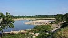
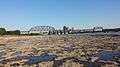
Falls of the Ohio State Park is a state park in Indiana. It is located on the banks of the Ohio River at Clarksville, Indiana, across from Louisville, Kentucky. The park is part of the Falls of the Ohio National Wildlife Conservation Area. The exposed fossil beds of the Jeffersonville Limestone dated from the Devonian period are the main feature of the park. The Falls was the site where Lewis & Clark met for the Lewis and Clark Expedition.[1][2][3][4][5][6]

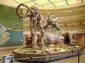
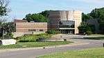
The park includes an interpretive center open to the public. In 1990 the Indiana state government hired Terry Chase, a well-established exhibit developer, to design the center's displays. Building started in September 1992, costing $4.9 million with a total area of 16,000 sq ft (1,500 m2).[7] The center functions as a museum with exhibits that concentrate on the natural history related to findings in the nearby fossil beds as well as the human history of the Louisville area, covering pre-settlement, early settlement, and Louisville and southern Indiana history all the way up through the 20th century.

Unlike at other Indiana state parks, annual entrance permits do not allow unlimited free access (rather, only five people per pass per visit) to the interpretive center, as fees are still needed to reimburse the town of Clarksville for building the center.
The Woodland Loop Trail has ten new stainless steel markers denoting the plant life of the trails, thanks to an Eagle Scout project.[8]
Strange wildlife has a habit of showing up in the park. Living alligators and crocodiles have also been seen in the park.[9] In August 2006 a fisherman hooked a dead octopus. Zachary Treitz, a 21-year-old Louisville college student, admitted he had put the octopus there after purchasing it dead from a local seafood shop for a film project.[10]
Gallery
-
Interpretive Center Lobby
-
-
-
See also
- The Filson Historical Society
- List of attractions and events in the Louisville metropolitan area
- List of fossil sites
- Old Clarksville Site
References
- ↑ "Indiana Lewis and Clark Bicentennial Commission". In.gov. Retrieved 2013-02-20.
- ↑ "Kentucky places : Louisville and the Falls of the Ohio". Lewis and Clark in Kentucky. Retrieved 2013-02-20.
- ↑ "At the Falls of the Ohio". Lewis-clark.org. Retrieved 2013-02-20.
- ↑ "Old Clarksville Site-Lewis and Clark Expedition: A National Register of Historic Places Travel Itinerary". Nps.gov. Retrieved 2013-02-20.
- ↑ "IHB: Lewis and Clark-Indiana connections - Focus". In.gov. 2009-06-16. Retrieved 2013-02-20.
- ↑ "Part 4: Ohio River - Lewis and Clark - Corps of Discovery - U.S. Army Center of Military History". History.army.mil. Retrieved 2013-02-20.
- ↑ Kramer, Carl. This Place We Call Home (Indiana University Press, 2007) p.495)
- ↑ "Scout project enhances Woodland trail". News and Tribune.
- ↑ "Fisherman finds octopus in Ohio River". News and Tribune.
- ↑ Schneider, Grace. "Octopus pulled from river was leftover from student's film project". The Courier-Journal. Retrieved 2009-04-16.
- WikiMapia
- United States Geological Survey. "Falls of the Ohio State Park, USGS New Albany (IN,KY) Topo Map". TopoQuest. Retrieved 2008-06-29.
External links
- Falls of the Ohio Organization
- Falls of the Ohio State Park - Indiana Department of Natural Resources
- Silurian and Devonian Geology and Paleontology at the Falls of the Ohio, Kentucky/Indiana - 42nd Annual Meeting of the American Institute of Professional Geologists, fieldtrip guidebook, 2005
| History |
|  |
|---|---|---|
| Geography |
| |
| Government |
| |
| Transportation | ||
| Other subject areas | ||
| Top subjects | ||
| National Historic Landmarks | ||
| Prominent suburbs (over 10K pop.) | ||
| ||