Fanling Station
Fanling 粉嶺 | ||||||||||||||||||||||||||||||||||||
|---|---|---|---|---|---|---|---|---|---|---|---|---|---|---|---|---|---|---|---|---|---|---|---|---|---|---|---|---|---|---|---|---|---|---|---|---|
| MTR rapid transit station | ||||||||||||||||||||||||||||||||||||
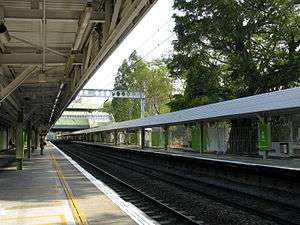 Station Platform | ||||||||||||||||||||||||||||||||||||
| Chinese name | ||||||||||||||||||||||||||||||||||||
| Traditional Chinese | 粉嶺 | |||||||||||||||||||||||||||||||||||
| Simplified Chinese | 粉岭 | |||||||||||||||||||||||||||||||||||
| ||||||||||||||||||||||||||||||||||||
| General information | ||||||||||||||||||||||||||||||||||||
| Location |
Fanling Station Road, Fanling North District, Hong Kong | |||||||||||||||||||||||||||||||||||
| Coordinates | 22°29′32″N 114°08′19″E / 22.4921°N 114.1387°ECoordinates: 22°29′32″N 114°08′19″E / 22.4921°N 114.1387°E | |||||||||||||||||||||||||||||||||||
| Owned by | Kowloon–Canton Railway Corporation | |||||||||||||||||||||||||||||||||||
| Operated by | MTR Corporation | |||||||||||||||||||||||||||||||||||
| Line(s) | ||||||||||||||||||||||||||||||||||||
| Platforms | 2 (side platforms) | |||||||||||||||||||||||||||||||||||
| Connections | Bus, public light bus | |||||||||||||||||||||||||||||||||||
| Construction | ||||||||||||||||||||||||||||||||||||
| Structure type | At-grade | |||||||||||||||||||||||||||||||||||
| Platform levels | 1 | |||||||||||||||||||||||||||||||||||
| Disabled access | Yes | |||||||||||||||||||||||||||||||||||
| History | ||||||||||||||||||||||||||||||||||||
| Opened |
| |||||||||||||||||||||||||||||||||||
| Electrified | 1983 | |||||||||||||||||||||||||||||||||||
| Services | ||||||||||||||||||||||||||||||||||||
| ||||||||||||||||||||||||||||||||||||
| Location | ||||||||||||||||||||||||||||||||||||
|
Fanling Location within the MTR system | ||||||||||||||||||||||||||||||||||||
Fanling (Chinese: 粉嶺) is a station on the East Rail Line of the Hong Kong MTR. It is next to Fanling Town Centre, and is only a short walk away from Fung Ying Seen Koon, a well-known Taoist temple. The Fanling Highway was built from 1983 to 1987 directly adjacent to the station. The station is located on Fanling Station Road within the Fanling area in North District, New Territories, Hong Kong.
History
The station once served as the terminus of the Sha Tau Kok Railway, which ceased operations on 1 April 1928. The station also served as the terminus for the now-defunct Wo Hop Shek branch line, which ran from Fanling station to the Wo Hop Shek Public Cemetery. The branch line was only used for special services during the Ching Ming and Chung Yeung festivals. The Wo Hop Shek branch line was taken out of service in 1983 after electrification along the East Rail Line.
Station layout
| C | Concourse | Exit, Tickets/Fare Adjustment, Shops, ATMs |
| Footbridge | Footbridge to Fanling Town, Pak Wo Road | |
| Platforms | ||
| Side platform, doors will open on the left | ||
| Platform 1 | East Rail Line towards Lo Wu or Lok Ma Chau (Sheung Shui) → | |
| Platform 2 | ← East Rail Line towards Hung Hom (Tai Wo) | |
| Side platform, doors will open on the left | ||
| Fanling Station Road Exit | Exit, Tickets/Fare Adjustment, Transport Interchange | |
Exits
- Concourse[2]
- A: Fanling Town Centre
- A1: San Wan Road

- A2: Fanling Station Road
- A3: Public light bus terminus and taxi stand
- A1: San Wan Road
- B: Fanling South (Pak Wo Road)
- Platform 2[2]
- C: Fanling Town Centre, public light bus terminus and taxi stand
Transport interchange
- 70K- Wah Ming ↺ Ching Ho Estate
- 78K- Sheung Shui ↔ Sha Tau Kok
- 79K- Sheung Shui ↔ Ta Kwu Ling
- 270A- Sheung Shui ↔ Tsim Sha Tsui East (Mody Road)
- 270B - Sheung Shui ↔ Sham Shui Po (Rush Time Service)
- 270P - Sheung Shui → Kowloon Station (Morning Rush Time Service)
- 273- Wah Ming ↺ Fanling Station
- 273A- Choi Yuen ↺ Wah Ming
- 273D- Sheung Shui ↺ Wah Ming
- 277X- Luen Wo Hui ↔ Lam Tin Station
- 278K- Luen Wo Hui ↺ Fanling Station
- 278P- Luen Wo Hui → Tsuen Wan (Nina Tower) (Morning Rush Time Service)
- 278X- Sheung Shui ↔ Tsuen Wan (Nina Tower)
- 279X- Luen Wo Hui ↔ Tsing Yi Station
- Cross Harbour Tunnel Bus[2]
- 373- Sheung Shui ↔ Sheung Wan (Rush Time Service)
- 678- Sheung Shui ↔ Causeway Bay (Rush Time Service)
- 978- Wah Ming ↔ Wan Chai (North)
- A43- Luen Wo Hui ↔ Airport (Ground Transportation Centre)
- N42A- Luen Wo Hui ↔ Tung Chung Station (Midnight Service)
- 52A- Fanling Station ↔ Luen Wo Hui
- 52B- Fanling Station ↔ Hok Tau
- 52K- Fanling Station ↔ Ping Che
- 54A- Fanling Station ↔ Luen Wo Hui
- 54K- Fanling Station ↺ Lung Yeuk Tau
- 56A- Fanling Station ↔ Luen Wo Hui
- 56B- Fanling Station ↔ Tan Chuk Hang
- 56C- Fanling Station ↔ Siu Hang Tsuen
- 56K- Fanling Station ↔ Luk Keng
- 501A- Yung Shing Court ↺ Luen Wo Hui
- 501K- Yan Shing Court ↺ Luen Wo Hui
References
- ↑ "Fanling Station layout" (PDF). MTR Corporation. Retrieved 14 November 2014.
- 1 2 3 4 5 6 "Fanling Station street map" (PDF). MTR Corporation. Retrieved 14 November 2014.
External links
| Wikimedia Commons has media related to Fanling Station. |