Farmington, New York
| Farmington | |
|---|---|
| Town | |
 Farmington Location within the state of New York | |
| Coordinates: 42°58′51″N 77°19′19″W / 42.98083°N 77.32194°WCoordinates: 42°58′51″N 77°19′19″W / 42.98083°N 77.32194°W | |
| Country | United States |
| State | New York |
| County | Ontario |
| Government | |
| • Type | Town Council |
| • Town Supervisor | Peter Ingalsbe (R) |
| • Town Council |
Members' List
|
| Area | |
| • Total | 39.4 sq mi (102.2 km2) |
| • Land | 39.4 sq mi (102.2 km2) |
| • Water | 0.0 sq mi (0.0 km2) |
| Elevation | 577 ft (176 m) |
| Population (2010) | |
| • Total | 11,825 |
| Time zone | Eastern (EST) (UTC-5) |
| • Summer (DST) | EDT (UTC-4) |
| ZIP code | 14425 |
| Area code(s) | 585 315 |
| FIPS code | 36-25406 |
| GNIS feature ID | 0978953 |
Farmington is a town located in the northern part of Ontario County, New York, United States. The population was 11,825 at the 2010 census.[1] Farmington is about twenty-five miles southeast of Rochester, New York. The town was named after Farmington, Connecticut.
History
Farmington was part of the Phelps and Gorham Purchase. The town was formed along with its county in 1789, and settlement of the region began the same year. Many of the early settlers were Quakers from Berkshire County, Massachusetts. In 1824, Arthur Power left Farmington with two of his sons and other Quakers to found Farmington, Michigan.
The Farmington Quaker Crossroads Historic District was listed on the National Register of Historic Places in 2007.[2]
Geography
The land, at an average elevation of 600 feet above sea level, is compressed by the Wisconsin glaciation and slopes from an elevation of 700 feet at the southern border with the town of Canandaigua, to 500 feet at the north boundary with the town of Macedon. The land comprises drumlins and eskers. Other than streams and ponds, there are no major water landmarks. Public drinking water is provided by treated water piped from Canandaigua Lake.
According to the United States Census Bureau, the town has a total area of 39.5 square miles (102 km2), all of it land.
The New York State Thruway (Interstate 90) passes across the town. New York State Route 332 is a north-south highway, and New York State Route 96 is an east-west highway.
The north town line is shared by the town of Macedon in Wayne, County.
Demographics
| Historical population | |||
|---|---|---|---|
| Census | Pop. | %± | |
| 1820 | 4,214 | — | |
| 1830 | 1,773 | −57.9% | |
| 1840 | 2,122 | 19.7% | |
| 1850 | 1,876 | −11.6% | |
| 1860 | 1,858 | −1.0% | |
| 1870 | 1,896 | 2.0% | |
| 1880 | 1,978 | 4.3% | |
| 1890 | 1,703 | −13.9% | |
| 1900 | 1,607 | −5.6% | |
| 1910 | 1,568 | −2.4% | |
| 1920 | 1,465 | −6.6% | |
| 1930 | 1,477 | 0.8% | |
| 1940 | 1,453 | −1.6% | |
| 1950 | 1,399 | −3.7% | |
| 1960 | 2,114 | 51.1% | |
| 1970 | 3,565 | 68.6% | |
| 1980 | 8,933 | 150.6% | |
| 1990 | 10,381 | 16.2% | |
| 2000 | 10,585 | 2.0% | |
| 2010 | 11,825 | 11.7% | |
| Est. 2014 | 12,904 | [3] | 9.1% |
As of the census[1] of 2000, there were 10,585 people, 3,870 households, and 2,894 families residing in the town. The population density was 268.3 people per square mile (103.6/km²). There were 4,046 housing units at an average density of 102.6 per square mile (39.6/km²). The racial makeup of the town was 96.53% White, 1.02% African American, 0.26% Native American, 0.94% Asian, 0.01% Pacific Islander, 0.26% from other races, and 0.97% from two or more races. Hispanic or Latino of any race were 1.21% of the population.
There were 3,870 households out of which 40.4% had children under the age of 18 living with them, 60.2% were married couples living together, 10.7% had a female householder with no husband present, and 25.2% were non-families. 18.6% of all households were made up of individuals and 4.7% had someone living alone who was 65 years of age or older. The average household size was 2.73 and the average family size was 3.14.
In the town the population was spread out with 28.7% under the age of 18, 7.6% from 18 to 24, 32.0% from 25 to 44, 25.0% from 45 to 64, and 6.6% who were 65 years of age or older. The median age was 35 years. For every 100 females there were 95.8 males. For every 100 females age 18 and over, there were 93.4 males.
The median income for a household in the town was $49,863, and the median income for a family was $54,769. Males had a median income of $39,645 versus $26,097 for females. The per capita income for the town was $20,756. About 3.7% of families and 5.6% of the population were below the poverty line, including 6.8% of those under age 18 and 5.0% of those age 65 or over.
Notable people
- Elbridge G. Lapham, former US Senator
- Harold F. Loomis, biologist
The Ontario County Wiffle Association also calls Farmington home. The league has produced the 2012 National Champion Freaky Franchise and 2014 National Champion HTML.
Communities and other locations in the town
- Blacksmith Corners – A location in the southeast part of the town on NY-96.
- Brownsville – A hamlet near the west town line in the northern part of the town.
- Farmbrook – A location in central Farmington.
- Farmington – A hamlet south of the Thruway on County Road 8.
- Hathaway Corners – A hamlet in the southwest part of the town at the junction of NY-332 and County Road 41.
- Ingleside Corner – A location by the west town line on NY-332.
- Mertensia (Previously called "West Farmington") – An hamlet in the southwest part of the town on County Road 41.
- New Salem – An historic location near the north town line.
- Pumpkin Hook – A community in the northwestern part of the town near Allen-Padgham Rd and Hook Rd.
- The Grove -- A neighborhood that encompasses the Farmington Grove Park.
Business
- Finger Lakes Gaming and Race Track – The only privately owned Thoroughbred horse-racing track in New York state.
- Ultrafab – Manufacturer of weatherstripping and related products
- Unisource – Supply company
Public safety
Fire protection is provided by the Farmington Volunteer Fire Assoc., which has two fire stations within the town: Station #1, located in "Pumpkin Hook" in the north section and Station #2, located at State Route 96 and Hook Rd near the business district.
The Ontario County Sheriff's department provides law enforcement in the town as well as the New York State Police. The New York State Police Troop E headquarters is located in Farmington and serves a 10-county region.
Victor-Farmington Volunteer Ambulance provides EMS service to the town.[5] Farmington is also provided advanced emergency medical service by the Ontario County Advanced Life Support unit as well as Mercy Flight, a locally based medivac helicopter.
References
- 1 2 "American FactFinder". United States Census Bureau. Retrieved 2008-01-31.
- ↑ National Park Service (2009-03-13). "National Register Information System". National Register of Historic Places. National Park Service.
- ↑ "Annual Estimates of the Resident Population for Incorporated Places: April 1, 2010 to July 1, 2014". Retrieved June 4, 2015.
- ↑ "Census of Population and Housing". Census.gov. Retrieved June 4, 2015.
- ↑ "Victor Farmington Volunteer Ambulance Corps, Inc.". Retrieved 2009-06-17.
External links
Municipalities and communities of Ontario County, New York, United States | ||
|---|---|---|
| Cities | 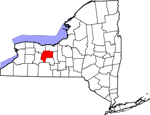 | |
| Towns | ||
| Villages | ||
| CDPs |
| |
| Other hamlets | ||
| Footnotes | ‡This populated place also has portions in an adjacent county or counties | |