Felsenthal National Wildlife Refuge
| Felsenthal National Wildlife Refuge | |
|---|---|
|
IUCN category IV (habitat/species management area) | |
|
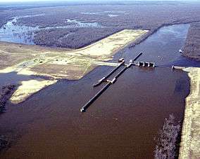
Felsenthal Lock and Dam, impounding Lake Jack Lee in the Felsenthal National Wildlife Refuge | |
 Map of the United States | |
| Location | Arkansas, United States |
| Nearest city | Crossett, Arkansas |
| Coordinates | 33°05′25″N 92°08′31″W / 33.090409°N 92.141819°WCoordinates: 33°05′25″N 92°08′31″W / 33.090409°N 92.141819°W |
| Area | 64,902 acres (262.65 km2) |
| Established | 1970 |
| Governing body | U.S. Fish and Wildlife Service |
| Website | Felsenthal NWR |
The Felsenthal National Wildlife Refuge is a 64,902 acre (262.65 km2) [1] wildlife refuge located in south-central Arkansas in Ashley, Bradley, and Union counties. It is the world's largest green tree reservoir.
The Felsenthal National Wildlife Refuge is a wetlands complex near Lake Jack Lee, which is located on the confluence of the Saline and Ouachita Rivers. It is made up of various streams, creeks, lakes, and sloughs.
In addition to the wetland lowlands the refuge has areas of pine and upland hardwood forests. The refuge is home to migratory and resident waterfowl as well as marsh and water birds. The park is also home to a large population of red-cockaded woodpeckers and is a habitat of the bald eagle and American alligator.
The refuge also contains over 200 Native American archaeological sites, primarily from the Caddo tribe that lived in the area as long as 5,000 years ago. These sites include the remains of seasonal fishing camps, ceremonial plazas, temple mounds and large villages containing as many as 200 structures.
The refuge was created in 1970.