Flatside Wilderness
| Flatside Wilderness | |
|---|---|
|
IUCN category Ib (wilderness area) | |
 | |
 Location in the United States | |
| Coordinates | 34°51′35″N 92°56′51″W / 34.85972°N 92.94750°WCoordinates: 34°51′35″N 92°56′51″W / 34.85972°N 92.94750°W |
| Area | 9,507 acres (3,847 ha) |
| Created | October 19, 1984 |
The Flatside Wilderness is a rugged 9,507 acre[1] segment of the Ouachita National Forest in the U.S. state of Arkansas. Visitors can enjoy the area in a number of ways such as hiking a 10.5 mile section of the Ouachita National Recreation Trail.
Location
The Flatside Wilderness extends 20 miles (32 km) from east to west. It is located primarily in Saline County and is only 20 miles (32 km) from Little Rock. The area is bound by Arkansas Highway 9 to the east and Arkansas Highway 7 to the west.
History
The Flatside Wilderness was designated by passage of "The Arkansas Wilderness Act of 1984", Public Law 98-508, which was signed by President Ronald Reagan on October 19, 1984. Senator Dale Bumpers (D-AR) sponsored the Act in the United States Senate, which was co-sponsored by Senator David Pryor (D-AR) and Senator John Tower (R-TX). Earlier versions of the bill called "The Arkansas Wilderness Act of 1983"[2] had been sponsored in the House of Representatives by Representative Ed Bethune (R-AR) and Representative Beryl Anthony (D-AR).
Geography

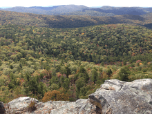
The Flatside Wilderness is a remote area featuring a number of outcrops over 1,000 ft in elevation. The highest is White Oak Mountain (1,792 ft) on its southwest boundary. Others include Crystal Mountain (1,732 ft), Flatside Pinnacle (1,526 ft), North Fork Pinnacle (1,516 ft), Forked Mountain (1,108 ft), and much more. These rise high above the canopy of trees and offer outdoor enthusiasts a spectacular view of the Ouachita Mountains. Mount Magazine, the highest point in Arkansas, can even be seen to the west on clear days, particularly in the winter. Several small creeks flow through the area; the dominant creek is Crystal Prong on the eastern edge of the area, which flows into Cedar Creek. The Little Cedar Creek flows along the eastern edge of Forked Mountain and eventually empties into Cedar Creek just before its confluence with the South Fourche La Fave River.
Geology
According to the Arkansas Geological Survey, the Flatside Wilderness consists of two chronostratigraphic units: the Stanley Group (Ms) and the Jackfork Group (Pj). The Stanely Group, deposited during the Mississippian Period (358.9-323.2– Ma), consists of thin-bedded, fine-grained, gray to red shale. The Jackfork Group, deposited during the Pennsylvanian Period (323.2-298.9 Ma), consists of massive-bedded, fine-grained, brown to tan sandstone. Both resulted from sediment gravity flows on the southern margin of the North American Craton. In the late Paleozoic, convergent forces thrusted these partially lithified sediments into an accretionary prism (the event that uplifted the Ouachita Mountains). They were significantly eroded by the early Mesozoic, leaving the steeply dipping outcrops seen throughout the Flatside Wilderness today.
Sites of Interest
- Crystal Mountain
- Flatside Pinnacle
- Lake Sylvia
- Lake Winona
See also
References
- ↑ "Wilderness Areas" (PDF). Ouachita National Forest. Retrieved 2013-04-22.
- ↑ "Arkansas Wilderness Act of 1984". Wilderness.net. Retrieved 2013-04-22.