Five Rivers (Oregon)
| Five Rivers | |
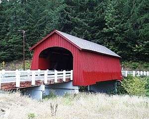 Fisher School Bridge crosses Five Rivers at Fisher | |
| Name origin: For five of the stream's tributaries [1] | |
| Country | United States |
|---|---|
| State | Oregon |
| Counties | Lincoln, Benton, Lane |
| Source | Central Oregon Coast Range |
| - location | Siuslaw National Forest |
| - elevation | 1,510 ft (460 m) [2] |
| - coordinates | 44°11′55″N 123°48′33″W / 44.19861°N 123.80917°W [3] |
| Mouth | Alsea River |
| - location | near Stoney Mountain |
| - elevation | 85 ft (26 m) [3] |
| - coordinates | 44°21′30″N 123°49′37″W / 44.35833°N 123.82694°WCoordinates: 44°21′30″N 123°49′37″W / 44.35833°N 123.82694°W [3] |
| Basin | 119 sq mi (308 km2) [4] |
 Location of the mouth of Five Rivers in Oregon | |
Five Rivers is a tributary of the Alsea River in the U.S. state of Oregon, in Lane, Lincoln, Benton counties.[3] The name Five Rivers refers to the relative importance to the stream of five of its tributaries: Alder, Cougar, Buck, Crab, and Cherry creeks.[1]
Five Rivers meanders generally north through the Siuslaw National Forest from its headwaters in the Central Oregon Coast Range west of Blachly in Lane County. It enters the Alsea River near Stoney Mountain, 25 miles (40 km) from the Alsea's mouth on the Pacific Ocean at Waldport.[5]
The rural community of Paris lies 17 miles (27 km) by river from the mouth of Five Rivers. About 7 miles (11 km) further downstream is another rural community, Fisher, near the confluence of Five Rivers with Crab Creek.[5] Fisher School Bridge, a covered bridge for pedestrians, crosses Five Rivers at Fisher.[1]
Recreation
Five Rivers Launch is a day-use area near the Five Rivers – Alsea confluence and the intersection of Five Rivers Road with Oregon Route 34, which runs along the Alsea. Managed by Lincoln County, the launch includes a gravel boat ramp and a parking area. The launch is only for drift boats such as canoes and kayaks.[6]
Tributaries
Named tributaries of Five Rivers from source to mouth are Prindel, Lord, Summers, Cedar, and Fendall creeks followed by Green River. Then come Crazy, Alder, Crab, Cougar, Buck, and Cherry creeks. Below that are Cascade, Swamp, Lobster, Elk, and Bear creeks.[5]
See also
References
- 1 2 3 "Five Rivers (Fisher School) Covered Bridge" (PDF). Oregon Department of Transportation. Retrieved January 27, 2016.
- ↑ Source elevation derived from Google Earth search using GNIS source coordinates.
- 1 2 3 4 "Five Rivers". Geographic Names Information System (GNIS). United States Geological Survey. November 28, 1980. Retrieved January 26, 2016.
- ↑ "Lobster/Five Rivers Watershed Analysis" (PDF). Bureau of Land Management. p. 8. Retrieved January 27, 2016.
- 1 2 3 "United States Topographic Map". United States Geological Survey. Retrieved January 26, 2016 – via Acme Mapper. The map includes mile markers along the Alsea River and the lower reaches of Five Rivers.
- ↑ "Five Rivers Launch". Lincoln County Parks. Retrieved January 27, 2016.