Fisher, Oregon
| Fisher, Oregon | |
|---|---|
| Populated Place | |
|
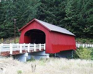
Fisher School Bridge crosses Five Rivers at Fisher | |
 Fisher, Oregon | |
| Coordinates: 44°17′30″N 123°50′24″W / 44.29167°N 123.84000°WCoordinates: 44°17′30″N 123°50′24″W / 44.29167°N 123.84000°W | |
| Country | United States |
| State | Oregon |
| County | Lincoln |
| Elevation | 236 ft (72 m) |
| Time zone | Pacific (PST) (UTC-8) |
| • Summer (DST) | PDT (UTC-7) |
| ZIP code | 97390 |
| Area code(s) | 541 |
| GNIS feature ID | 1142172 |
| Coordinates and elevation from United States Geological Survey[1] | |
Fisher is an unincorporated community in rural Lincoln County, Oregon, United States.[1] Fisher lies along Five Rivers Road, 9.4 miles (15.1 km) south of its intersection with Oregon Route 34.[2] It is slightly north of the Lincoln–Lane county line in the Siuslaw National Forest.[3] A stream called Five Rivers flows north through Fisher, about 10 miles (16 km) by water from the stream's mouth on the Alsea River. Route 34 runs along the Alsea River between Alsea and Waldport.[3]
Fisher School Bridge crosses Five Rivers at Fisher. The bridge takes its name from Fisher Elementary School across Crab Creek Road, today a residence. Alternatively, the bridge is sometimes called Five Rivers Bridge.[4]
A post office named Fisher was established in this area in 1892 and closed in 1942. Martin Johanson was the first postmaster.[5]
Name
Fisher was named for the fisher (Martes pennanti), a cat-sized animal in the same family as the weasel, badger, otter, and mink. Once much more common in the virgin forests of the Oregon Coast Range, it was driven to near extinction in these mid-elevation mountains by habitat destruction, trapping, and poison baits meant to kill coyotes and wolves.[5]
References
- 1 2 "Fisher". Geographic Names Information System. United States Geological Survey. November 28, 1980. Retrieved January 28, 2016.
- ↑ Kimberling, Gail (August 14, 2005). "Covered Bridges of Lincoln County". Newport News–Times. Longview Daily News. Retrieved January 29, 2016 – via The Daily News Online.
- 1 2 "United States Topographic Map". United States Geological Survey. Retrieved January 28, 2016 – via Acme Mapper. The map includes mile markers along Five Rivers and the Alsea River.
- ↑ "Public Works: Fisher School Bridge". Lincoln County. Retrieved January 28, 2016.
- 1 2 McArthur, Lewis A.; McArthur, Lewis L. (2003) [1928]. Oregon Geographic Names (7th ed.). Portland, Oregon: Oregon Historical Society Press. p. 356. ISBN 0-87595-277-1.
Municipalities and communities of Lincoln County, Oregon, United States | ||
|---|---|---|
| Cities | 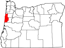 | |
| CDPs | ||
| Unincorporated communities | ||
| Indian reservation | ||