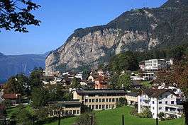
Flüelen
| Flüelen | ||
|---|---|---|
 | ||
| ||
 Flüelen | ||
|
Location of Flüelen 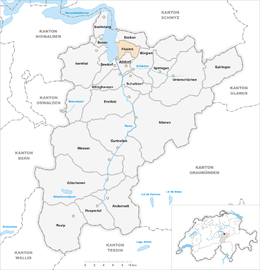 | ||
| Coordinates: 46°54′N 8°37′E / 46.900°N 8.617°ECoordinates: 46°54′N 8°37′E / 46.900°N 8.617°E | ||
| Country | Switzerland | |
| Canton | Uri | |
| District | n.a. | |
| Area[1] | ||
| • Total | 12.42 km2 (4.80 sq mi) | |
| Elevation | 435 m (1,427 ft) | |
| Population (Dec 2015[2]) | ||
| • Total | 1,972 | |
| • Density | 160/km2 (410/sq mi) | |
| Postal code | 6454 | |
| SFOS number | 1207 | |
| Surrounded by | Altdorf, Bauen, Bürglen, Isenthal, Seedorf, Sisikon | |
| Website |
www SFSO statistics | |

Flüelen is a municipality in the canton of Uri in Switzerland.
History
Flüelen is first mentioned in 1266 as Vluolon.[3]
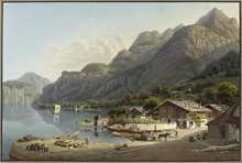
Flüelen formed an important transshipment point on Switzerland's transport system for many centuries, and at least since the opening of the first track across the Gotthard Pass in 1230. The various routes across the pass reached Lake Lucerne at Flüelen, and until the latter half of the 19th century the lake provided the best onward link to the cities of northern Switzerland.[4][5]
In 1906, the Altdorf–Flüelen tramway was constructed to connect the centre of Altdorf with Fluelen railway station. The electric tramway operated until 1951, when it was replaced by a bus service.[6]
Geography
Flüelen has an area, as of 2006, of 12.4 km2 (4.8 sq mi). Of this area, 22% is used for agricultural purposes, while 55.1% is forested. Of the rest of the land, 6.1% is settled (buildings or roads) and the remainder (16.8%) is non-productive (rivers, glaciers or mountains).[7] In the 1993/97 land survey, 49.0% of the total land area was heavily forested, while 0.1% is covered in small trees and shrubbery. Of the agricultural land, 0.2% is used for farming or pastures, while 6.8% is used for orchards or vine crops and 15.0% is used for alpine pastures. Of the settled areas, 2.3% is covered with buildings, 0.8% is industrial, 0.2% is classed as special developments, 0.5% is listed as parks and greenbelts and 2.4% is transportation infrastructure. Of the unproductive areas, 0.3% is unproductive standing water (ponds or lakes), 0.8% is unproductive flowing water (rivers), 4.1% is too rocky for vegetation, and 11.6% is other unproductive land.[8]
The municipality is located along Lake Lucerne. It developed as a transshipment point on the trade routes over the Gotthard pass and along the lake. It consists of the village of Flüelen, the outer village settlements and scattered farm houses in the valley and up the mountain sides.
Demographics
Flüelen has a population (as of 31 December 2015) of 1,972.[9] As of 2007, 10.1% of the population was made up of foreign nationals. Over the last 10 years the population has grown at a rate of 9.9%. Most of the population (as of 2000) speaks German (93.6%), with Italian being second most common ( 2.0%) and Albanian being third ( 1.6%).[7] As of 2007 the gender distribution of the population was 50.3% male and 49.7% female.[10]
In the 2007 federal election the FDP which received 87.7% of the vote.[7]
In Flüelen about 65.8% of the population (between age 25-64) have completed either non-mandatory upper secondary education or additional higher education (either university or a Fachhochschule).[7]
Flüelen has an unemployment rate of 1.86%. As of 2005, there were 44 people employed in the primary economic sector and about 16 businesses involved in this sector. 256 people are employed in the secondary sector and there are 19 businesses in this sector. 387 people are employed in the tertiary sector, with 56 businesses in this sector.[7]
The historical population is given in the following table:[3][11]
| year | population |
|---|---|
| 1685 | 337 |
| 1743 | 372 |
| 1799 | 469 |
| 1850 | 600 |
| 1880 | 1,420 |
| 1900 | 941 |
| 1950 | 1,645 |
| 2000 | 1,787 |
| 2005 | 1,874 |
| 2007 | 1,897 |
Transport
Flüelen railway station, on the Gotthard railway, is served by hourly InterRegio trains, and by line S2 of the Stadtbahn Zug, which operates hourly between Zug, Arth-Goldau and Erstfeld. The adjacent steamer pier is served by steamer services to and from Lucerne that are provided by the Schifffahrtsgesellschaft des Vierwaldstättersees (Lake Lucerne Navigation Company; SGV).
References
- ↑ Arealstatistik Standard - Gemeindedaten nach 4 Hauptbereichen
- ↑ Swiss Federal Statistical Office - STAT-TAB, online database – Ständige und nichtständige Wohnbevölkerung nach institutionellen Gliederungen, Geburtsort und Staatsangehörigkeit (German) accessed 30 August 2016
- 1 2 Flüelen in German, French and Italian in the online Historical Dictionary of Switzerland.
- ↑ "Paddle Steamboat Uri" (PDF). American Society of Mechanical Engineers. 2008-09-05. Retrieved 2012-09-11.
- ↑ "Geschichte SGV" [SGV History] (in German). SGV. Retrieved 2012-09-12.
- ↑ "Altdorf–Flüelen". www.eingestellte-bahnen.ch. Retrieved 2012-09-17.
- 1 2 3 4 5 Swiss Federal Statistical Office accessed 09-Sep-2009
- ↑ Canton Uri - Ground use statistics (German) accessed 8 September 2009
- ↑ Swiss Federal Statistical Office - STAT-TAB, online database – Ständige und nichtständige Wohnbevölkerung nach institutionellen Gliederungen, Geburtsort und Staatsangehörigkeit (German) accessed 30 August 2016
- ↑ Uri Population statistics (German) accessed 8 September 2009
- ↑ Uri in Numbers 2009/10 edition (German) accessed 8 September 2009
| Wikimedia Commons has media related to Flüelen. |
External links
- Flüelen in German, French and Italian in the online Historical Dictionary of Switzerland.
- Flüelen Official Homepage