Flakstadvåg
| Flakstadvåg | |
|---|---|
| Village | |
|
View of the village | |
 Flakstadvåg  Flakstadvåg Location in Troms | |
| Coordinates: 69°11′24″N 17°01′58″E / 69.19000°N 17.03278°ECoordinates: 69°11′24″N 17°01′58″E / 69.19000°N 17.03278°E | |
| Country | Norway |
| Region | Northern Norway |
| County | Troms |
| District | Midt-Troms |
| Municipality | Torsken |
| Elevation[1] | 3 m (10 ft) |
| Time zone | CET (UTC+01:00) |
| • Summer (DST) | CEST (UTC+02:00) |
| Post Code | 9393 Flakstadvåg |
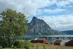
Flakstadvåg is a village in the municipality of Torsken in Troms county, Norway. It is located along the Selfjorden on the southwestern part of the island of Senja. It is surrounded by the fjord, mountains, and a marsh. There is one road connection to the village from the outside world. Ånderdalen National Park lies just to the northeast of the village. Flakstadvåg Chapel is located here.
References
- ↑ "Flakstadvåg" (in Norwegian). yr.no. Retrieved 2012-12-02.
This article is issued from Wikipedia - version of the 8/5/2016. The text is available under the Creative Commons Attribution/Share Alike but additional terms may apply for the media files.