Torsken
| Torsken kommune Doaskku suohkan | |||
|---|---|---|---|
| Municipality | |||
|
Medby, Torsken | |||
| |||
 Torsken within Troms | |||
| Coordinates: 69°17′47″N 17°2′11″E / 69.29639°N 17.03639°ECoordinates: 69°17′47″N 17°2′11″E / 69.29639°N 17.03639°E | |||
| Country | Norway | ||
| County | Troms | ||
| District | Midt-Troms | ||
| Administrative centre | Gryllefjord | ||
| Government | |||
| • Mayor (2007) | Fred Flakstad (Gryllefjord bygdeliste) | ||
| Area | |||
| • Total | 243.20 km2 (93.90 sq mi) | ||
| • Land | 235.08 km2 (90.76 sq mi) | ||
| • Water | 8.12 km2 (3.14 sq mi) | ||
| Area rank | 308 in Norway | ||
| Population (2012) | |||
| • Total | 892 | ||
| • Rank | 407-408 in Norway | ||
| • Density | 3.8/km2 (10/sq mi) | ||
| • Change (10 years) | -21.0 % | ||
| Demonym(s) | Torskeværing[1] | ||
| Time zone | CET (UTC+1) | ||
| • Summer (DST) | CEST (UTC+2) | ||
| ISO 3166 code | NO-1928 | ||
| Official language form | Bokmål | ||
| Website |
www | ||
|
| |||


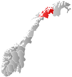
Torsken is a municipality on the western coast of the large island of Senja in Troms county, Norway. The administrative centre of the municipality is the village of Gryllefjord. Other larger villages in Torsken municipality include the village of Torsken, Medby, and Flakstadvåg.
The historic Torsken Church in the village of Torsken dates back to the 18th century. Ånderdalen National Park is located partially in Torsken and neighboring Tranøy municipalities.
General information
The municipality of Torsken was established on 1 January 1902 when it was separated from the municipality of Berg. The initial population of Torsken was 1,229. On 1 January 1964, the Rødsand area of Torsken (population: 160) was transferred to the neighboring municipality of Tranøy.[2]
Name
The municipality (originally the parish) is named after the old Torsken farm (Old Norse: Þoskar), since the first church (Torsken Church) was built there. The farm is named after Torsken mountain, and that name is probably derived from Norse þo(r)skr which means "cod". (Several mountains in Norway are named after their likeness with a fish.)[3]
Coat-of-arms
The coat-of-arms is from modern times. They were granted on 23 March 1990. The arms show a gold-colored anchor cross (Norwegian: ankerkors) on a black background. It is a symbol for both Christianity and the importance of the local harbor. The economy of Torsken is largely dependent on its harbors and an anchor is an appropriate symbol.[4]
Churches
The Church of Norway has one parish (sokn) within the municipality of Torsken. It is part of the Senja deanery in the Diocese of Nord-Hålogaland.
| Parish (Sokn) | Church Name | Location of the Church | Year Built |
|---|---|---|---|
| Torsken | Torsken Church | Torsken | 1784 |
| Flakkstadvåg Chapel | Flakstadvåg | 1925 | |
| Gryllefjord Chapel | Gryllefjord | 1902 | |
| Medby Chapel | Medby | 1890 |
Economy
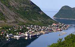
Most of the inhabitants live in the fishing village of Gryllefjord in the northern part of the municipality. The second most important village is Torsken, only a few kilometers to the south. Kaldfarnes/Medby, Grunnfarnes, and Flakstadvåg are other fishing villages further south. The municipality is close to the resources of the major fishing grounds off the Vesterålen archipelago, and 2004 landed 9.8 million tons of fish with a value of NOK 76.3 million for fish-processing in Torsken, Gryllefjord, Kaldfarnes, and Grunnfarnes. Most people work in the fields of fishing or fish processing.
The municipality has few productive forests, but there are some spruce trees planted in sheltered areas. In the southern parts of Torsken there is some usable farmland. There are five farms with more than 5 decares (0.0050 km2; 0.0019 sq mi) of agricultural land in the entire municipality (as of 1999).[5]
Transportation
The Andenes–Gryllefjord Ferry that goes across the Andfjorden to Andenes on the island of Andøya is operated during about two months each summer. The road from the northern part of the municipality to Kaldfarnes, Grunnfarnes, and Flakstadvåg is far from direct. One must drive north and then east to Berg and then south to Tranøy before turning northwest and returning to Torsken. These are the only road connections from the rest of Norway to Torsken.
Government
All municipalities in Norway, including Torsken, are responsible for primary education (through 10th grade), outpatient health services, senior citizen services, unemployment and other social services, zoning, economic development, and municipal roads. The municipality is governed by a municipal council of elected representatives, which in turn elect a mayor.
Municipal council
The municipal council (Kommunestyre) of Torsken is made up of 15 representatives that are elected to every four years. Currently, the party breakdown is as follows:[6]
| Party Name | Name in Norwegian | Number of representatives | |
|---|---|---|---|
| Labour Party | Arbeiderpartiet | 9 | |
| Centre Party | Senterpartiet | 6 | |
| Total number of members: | 15 | ||
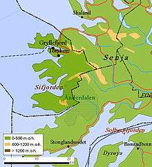
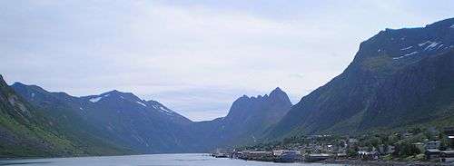
Geography
Torsken is a rugged area on the west coast of the island of Senja. Many different fjords cut into its mountainous coastline including Sifjorden, Selfjorden, Torskefjorden, Gryllefjorden, and Skipsfjorden. Between mountain peaks that range from 600 to 1,000 metres (2,000 to 3,300 ft), there are deep valleys and narrow depressions. Many of the valleys contain marshes or lakes. The bedrock under Torsken consists mostly of gneiss and granite.[5]
Climate
| Climate data for Gryllefjord, Torsken | |||||||||||||
|---|---|---|---|---|---|---|---|---|---|---|---|---|---|
| Month | Jan | Feb | Mar | Apr | May | Jun | Jul | Aug | Sep | Oct | Nov | Dec | Year |
| Daily mean °C (°F) | −2.5 (27.5) |
−2.5 (27.5) |
−1.4 (29.5) |
1.3 (34.3) |
5.4 (41.7) |
9.0 (48.2) |
11.5 (52.7) |
11.3 (52.3) |
7.8 (46) |
4.1 (39.4) |
0.6 (33.1) |
−1.6 (29.1) |
3.6 (38.5) |
| Average precipitation mm (inches) | 107 (4.21) |
93 (3.66) |
87 (3.43) |
76 (2.99) |
55 (2.17) |
67 (2.64) |
77 (3.03) |
91 (3.58) |
114 (4.49) |
150 (5.91) |
128 (5.04) |
130 (5.12) |
1,175 (46.26) |
| Source: Norwegian Meteorological Institute[7] | |||||||||||||
References
- ↑ "Navn på steder og personer: Innbyggjarnamn" (in Norwegian). Språkrådet. Retrieved 2015-12-01.
- ↑ Jukvam, Dag (1999). "Historisk oversikt over endringer i kommune- og fylkesinndelingen" (PDF) (in Norwegian). Statistisk sentralbyrå.
- ↑ Rygh, Oluf (1911). Norske gaardnavne: Troms amt (in Norwegian) (17 ed.). Kristiania, Norge: W. C. Fabritius & sønners bogtrikkeri. p. 77.
- ↑ Norske Kommunevåpen (1990). "Nye kommunevåbener i Norden". Retrieved 2008-12-08.
- 1 2 Store norske leksikon. "Torsken" (in Norwegian). Retrieved 2012-12-03.
- ↑ "Table: 04813: Members of the local councils, by party/electoral list at the Municipal Council election (M)" (in Norwegian). Statistics Norway. 2015.
- ↑ "eKlima Web Portal". Norwegian Meteorological Institute.
External links
 Media related to Torsken at Wikimedia Commons
 The dictionary definition of torsken at Wiktionary
 Troms travel guide from Wikivoyage
- Municipal fact sheet from Statistics Norway