Flushing Township, Michigan
| Charter Township of Flushing Flushing Charter Township | |
|---|---|
| Charter township | |
 Charter Township of Flushing Location within the state of Michigan | |
| Coordinates: 43°5′49″N 83°51′29″W / 43.09694°N 83.85806°WCoordinates: 43°5′49″N 83°51′29″W / 43.09694°N 83.85806°W | |
| Country | United States |
| State | Michigan |
| County | Genesee |
| Settled | 1835 |
| Organized | 1838 |
| Chartered | 1990 |
| Government | |
| • Supervisor | Rian Birchmeier |
| • Clerk | Julia A. Morford |
| • Treasurer | Maryion Lee |
| Area | |
| • Total | 31.0 sq mi (80.3 km2) |
| • Land | 30.9 sq mi (79.9 km2) |
| • Water | 0.2 sq mi (0.4 km2) 0.48% |
| Elevation | 699 ft (213 m) |
| Population (2010) | |
| • Total | 10,640 |
| • Density | 344.3/sq mi (133/km2) |
| Time zone | EST (UTC-5) |
| • Summer (DST) | EDT (UTC-4) |
| ZIP code | 48433 (Flushing) |
| Area code(s) | 810 |
| FIPS code | 26-29220[1] |
| GNIS feature ID | 1626290[2] |
| Website | http://www.flushingtownship.com |
Flushing Charter Township is a charter township of Genesee County in the U.S. state of Michigan. The population was 10,640 at the 2010 census.
Communities
- The city of Flushing is surrounded on three sides by the township, but is administratively autonomous. The Flushing ZIP code 48433 also serves the entire township.[3]
- Brent Creek is a small community within the township at 43°07′04″N 83°53′12″W / 43.11778°N 83.88667°W[4] on Mt. Morris Road between Nichols Road and Seymour Road.[5] Retiring after twenty years of U.S. diplomatic service in Spain and Portugal, Thomas Ludwell Lee Brent, a nephew of Virginia Congressman and Senator Richard Brent and grandson of Virginia colonial statesman Thomas Ludwell Lee, bought a large tract of land here and settled on it. In 1837, his workers built a mill on the Charlotte Creek, which was named for his daughter, but was later renamed Brent Creek. A post office named Brent Creek was established on November 2, 1888 with Frank J. Browne as the first postmaster. The spelling was changed to Brentcreek on June 25, 1894.[6]
History
In the fall of 1835, Rufus Harrison was the first settler in the future Flushing Township.[7] Flint Township was organized in 1836 and included the township areas of Burton, Clayton, Flushing, Mt. Morris, Genesee, Thetford, Vienna and Montrose. Genesee and Flushing Townships were split off on March 6, 1838.[8] Flushing Township originally included survey townships of 7 & 8 North in Range 5 East and the west half of 7 & 8 North in Range 6 East. At a meeting at Ezekiel R. Ewing's house, Dover was proposed by Ebenezer French as the township's name. However, since another Dover Township already existed in the state, the Michigan legislature chose Flushing. With a loss of early records, only the identity of the first clerk is known: Abiel C. Bliss. In October, 1838, the Township was divided into five school districts and appointed two school inspectors: Abiel C. Bliss and Jarvis Bailey.[9] Thomas L.L. Brent was a prominent early settler coming before 1836 and purchased up to 70,000 acres (280 km2) of Michigan land. He built a saw mill and dam in Section 3 on the Flint River, which was destroyed by a freshet. In the 1840, the "English Settlement" started to form in the Township's northwest area with settlers from England. The Village of Flushing was platted that same year.[7] Clayton Township (survey township 7N 5E) was split off in 1846. In 1855, the West half of survey township 8 North in Range 6 East was reunited with the East half to form Mt. Morris Township.[8]
Geography
According to the United States Census Bureau, the township has a total area of 31.0 square miles (80 km2), of which 30.9 square miles (80 km2) is land and 0.2 square miles (0.52 km2) (0.48%) is water.
Demographics
As of the census[1] of 2010, there were 10,640 people, 4,007 households, and 3,047 families residing in the township. The population density was 344.3` per square mile (133.0/km²). There were 4,007 housing units at an average density of 129.7 per square mile (50.8/km²). The racial makeup of the township was 98.4% White, 2.1% African American, 0.6% Native American, 0.8% Asian, and 1.6% from two or more races. Hispanic or Latino of any race were 2.4% of the population.
Of 4,007 households, 30.7% had children under the age of 18 living with them, 62.4% were married couples living together, 9.4% had a female householder with no husband present, 4.2% had a male householder with no wife present, and 24% were non-families. The average household size was 2.6 and the average family size was 3.0.
References
- 1 2 "American FactFinder". United States Census Bureau. Retrieved 2008-01-31.
- ↑ U.S. Geological Survey Geographic Names Information System: Flushing Township, Michigan
- ↑ 48433 5-Digit ZCTA, 484 3-Digit ZCTA - Reference Map - American FactFinder, U.S. Census Bureau, 2010 census
- ↑ U.S. Geological Survey Geographic Names Information System: Brent Creek, Michigan
- ↑ Genesee County Map. J. Shively. State of Michigan Department of Information Technology Technology Center for Genographic Information. September 2007.
- ↑ Romig, Walter (1986) [1973]. Michigan Place Names. Detroit, Michigan: Wayne State University Press. ISBN 0-8143-1838-X.
- 1 2 Wood, Edwin O. (1916). History of Genesee County, Michigan, Her People, Industries and Institutions Chapter V: Flushing Township. Michigan Historical Commission.
- 1 2 Wood, Edwin O. (1916). History of Genesee County, Michigan, Her People, Industries and Institutions. Michigan Historical Commission.
- ↑ Ellis, Franklin. "Flushing Township". History of Genesee county, Michigan. With illustrations and biographical sketches of its prominent men and pioneers. pp. 269, 271. Retrieved 2009-11-17.
External links
Municipalities and communities of Genesee County, Michigan, United States | ||
|---|---|---|
| Cities | 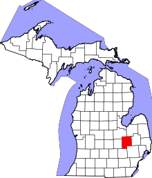 | |
| Villages | ||
| Charter townships | ||
| General law townships | ||
| Unincorporated communities | ||
| Footnotes | ‡This populated place also has portions in an adjacent county or counties | |