Forestburg, South Dakota
| Forestsburg, South Dakota | |
|---|---|
| Census-designated place | |
 Forestburg | |
| Coordinates: 43°53′52″N 98°8′22″W / 43.89778°N 98.13944°WCoordinates: 43°53′52″N 98°8′22″W / 43.89778°N 98.13944°W | |
| Country | United States |
| State | South Dakota |
| County | Sanborn |
| Area | |
| • Total | 0.62 sq mi (1.61 km2) |
| • Land | 0.60 sq mi (1.56 km2) |
| • Water | 0.02 sq mi (0.05 km2) |
| Elevation | 1,302 ft (397 m) |
| Population (2010)[1] | |
| • Total | 73 |
| • Density | 121/sq mi (46.8/km2) |
| Time zone | Central (CST) (UTC-6) |
| • Summer (DST) | CDT (UTC-5) |
| ZIP code | 57314 |
| Area code(s) | 605 |
| FIPS code | 46-22100 |
Forestburg is an unincorporated town and census-designated place in Sanborn County, South Dakota, United States.[2] The population was 73 at the 2010 census.[3]
The community was named for a tract of forest near the original town site.[4]
Education
Forestburg Public Schools are part of the Sanborn Central School District. The district includes an elementary school, middle school and high school. Students attend Sanborn Central High School.[5][6]
References
- ↑ "Forestburg, SD Population and Races". USA.com. Retrieved October 3, 2012.
- ↑ "Profile for Forestburg, South Dakota, SD". Podunk. Retrieved October 3, 2012.
- ↑ "Forestburg, SD Population and Races". USA.com. Retrieved October 3, 2012.
- ↑ Federal Writers' Project (1940). South Dakota place-names, v.1-3. University of South Dakota. p. 37.
- ↑ "Letcher South Dakota". Letcher South Dakota. Retrieved September 29, 2012.
- ↑ "Sanborn Central School District.". Sanborn Central School District. Retrieved October 3, 2012.
External links
| Wikimedia Commons has media related to Forestburg, South Dakota. |
- ePodunk: Profile for Forestburg, South Dakota, SD
- USA.com: Forestburg, SD Population and Races
- ZipAreaCode.net: Forestburg, SD
Municipalities and communities of Sanborn County, South Dakota, United States | ||
|---|---|---|
| City | 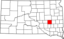 | |
| Towns | ||
| Township | ||
| CDP | ||
| Other unincorporated community | ||
This article is issued from Wikipedia - version of the 2/21/2016. The text is available under the Creative Commons Attribution/Share Alike but additional terms may apply for the media files.