Forry's Mill Covered Bridge
| Forry's Mill Covered Bridge | |
|---|---|
 | |
| Coordinates | 40°04′04″N 76°28′41″W / 40.0677°N 76.4780°WCoordinates: 40°04′04″N 76°28′41″W / 40.0677°N 76.4780°W |
| Locale | Lancaster County, Pennsylvania, United States |
| Official name | Big Chiques #7 Bridge |
| Characteristics | |
| Design | single span, double Burr arch truss |
| Total length | 103 feet (31.4 m) |
| History | |
| Constructed by | Elias McMellen |
| Construction begin | 1869 |
 | |
 | |
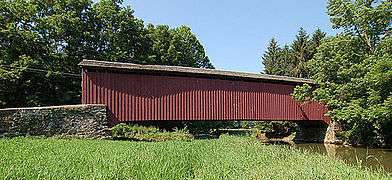
The Forry's Mill Covered Bridge is a covered bridge that spans Chiques Creek in West Hempfield in Lancaster County, Pennsylvania, United States.[1] A county-owned and maintained bridge, its official designation is the Big Chiques #7 Bridge.[2] (Chiques Creek was known as Chickies Creek until 2002).[3]
The bridge has a single span, wooden, double Burr arch trusses design with the addition of steel hanger rods. The deck is made from oak planks.[2] It is painted red, the traditional color of Lancaster County covered bridges, on both the inside and outside. Both approaches to the bridge are painted in the traditional white color.
The bridge's WGCB Number is 38-36-28.[4] In 1980 it was added to the National Register of Historic Places as structure number 80003512.[5] It is located at 40°4′3.6″N 76°28′40.8″W / 40.067667°N 76.478000°W (40.06767, -76.47800).[6]
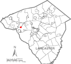
Forry's Mill Covered Bridge is located in West Hempfield Township[7] on Bridge Valley Road 0.4 km (0.25 mi) north of Pennsylvania route 23 5.5 km (3.4 mi) east of Marietta,[1] less than a mile away from the former site of the Siegrist's Mill Covered Bridge.[7]
History
Forry's Mill Covered Bridge was originally built in 1869 by Elias McMellen[1] for a cost of $2969. The bridge required repairs in 1925 to its sides and floor.[7]
Dimensions
- Length: 91 feet 6 inches (0.15 m) span and 103 feet (31 m) total length[4]
- Width: 12 feet 10 inches (3.91 m) clear deck and 15 feet (4.6 m) total width[4]
- Overhead clearance: 11 feet 6 inches (3.51 m)[1]
- Underclearance: 12 feet (3.7 m)
Gallery
- Wide view of the side of the bridge
 A closeup of the side of the bridge
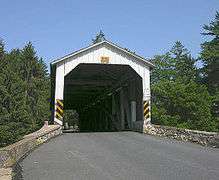 One of the approaches to the bridge
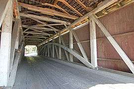 Inside of the bridge showing the Burr arch truss design
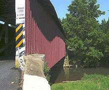
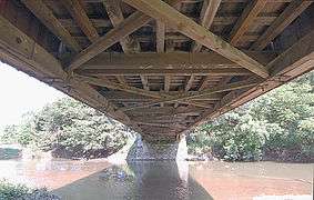 The underside of the bridge
See also
References
- 1 2 3 4 Bickel, Hank (2005-06-23). "Forry Mill Bridge". Covered Bridges of the Northeast USA. Retrieved 2006-08-04.
- 1 2 3 "Forry's Mill Covered Bridge". Lancaster County, PA Government Portal. County of Lancaster, Pennsylvania. 2001-10-30. Retrieved 2006-07-07.
- ↑ Geographic Names Information System, United States Geological Survey (August 30, 1990). "Geographic Names Information System Feature Detail Report: Chiques Creek". Retrieved 2006-09-05.
- 1 2 3 Dr. Roger A. McCain. "Forry's Mill Bridge". A Guide to Old Covered Bridges of Southeastern Pennsylvania and nearby areas. Retrieved 2006-08-03.
- ↑ "PENNSYLVANIA - Lancaster County". National Register of Historic Places. Retrieved 2007-03-20.
- ↑ Travis, Dale. "38-36-28". Round Barns & Covered Bridges. Retrieved 2006-08-08.
- 1 2 3 "Forry's Mill Covered Bridge". Lancaster County Pennsylvania Dutch Country Official Visitors Center. Pennsylvania Dutch Convention & Visitors Bureau. 2006. Retrieved 2006-07-07.
| Topics |   | |
|---|---|---|
| Lists by county |
| |
| Lists by city | ||
| Other lists | ||
| ||