Fort Lowell was a United States Army post active from 1873 to 1891 on the outskirts of Tucson, Arizona. Fort Lowell was the successor to Camp Lowell, an earlier Army installation.[1] The Army chose a location just south of the confluence of the Tanque Verde and Pantano creeks, at the point where they form the Rillito River, due to the year-round supply of water during that period. The Hohokam natives had chosen the site centuries earlier, presumably for the same reason. To this day, shards of Hohokam pottery can still be found in the area. The Army claimed a military reservation that encompassed approximately eighty square miles and extended east toward the Rincon Mountains.[2]
History
The Post of Tucson was established May 20, 1862, after the California Column drove Confederate forces from the area. The post was abandoned in July 1864 and reestablished in July 1865. On August 29, 1866 the post was renamed Camp Lowell in honor of General Charles Russell Lowell, who died from wounds sustained during the Battle of Cedar Creek. Initially located on the east side of Sixth Avenue, between Twelfth and Fourteenth Streets, the post was moved for sanitary reasons to a location about 7 miles (11 km) east of town on March 31, 1873. The post's name was changed to Fort Lowell on April 5, 1879.
Old West Era
The fort played a pivotal role during the Apache Wars, providing additional protection for the Tucson area. Far too large and well-manned to be attacked directly, Fort Lowell provided supplies and manpower for outlying military installations. During its eighteen years of operation, the fort averaged thirteen officers and 239 enlisted men. Among the units present during this period were the 2nd, 4th, 5th and 6th Cavalry Regiments, as well as the 1st, 8th, and 12th Infantry Regiments.[1]
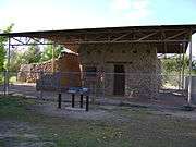
The orientation of the post was set according to magnetic north. It featured a large parade grounds, officers' quarters, quartermaster and commissary storehouses, corrals, quarters for enlisted men as well as for married non-commissioned officers. The most prominent building on post was the hospital, the adobe remnants of which still stand under a protective structure. A lane lined with cottonwood trees, aptly named Cottonwood Lane, graced the area in front of the officers' houses.
Among the more well known officers to have served at Fort Lowell were the young Walter Reed, the Army physician famous for his yellow fever research, and Charles Bendire, the amateur ornithologist after whom Bendire's thrasher is named.
After the Army decommissioned the post in 1891, Mexican families from Sonora soon moved north to take advantage of the free housing. This occupation has become known as the El Fuerte Period.[4]
Fort Lowell Park
|
|
Fort Lowell Park |
|
|
|
|
|

Fort Lowell Park Museum |
| Location |
2900 North Craycroft Road, Tucson, Arizona |
|---|
| Area |
20 acres (8.1 ha) |
|---|
| Built |
1878 |
|---|
| NRHP Reference # |
78003358 |
|---|
| Added to NRHP |
1978[5] |
|---|
The fort lay in ruins for many years and many of its adobe structures went into disrepair. Some of the portions of the fort were sold to the families in Tucson. Among the families which acquired in 1928, large portions where the fort was situated was the Adkins family. The Adkins family established a steel tank manufacturing business on the site. In 2006, the family handed over the site (known as the Adkins Parcel) to the City of Tucson. In 2009, the city in association with Pima County created a Master Plan for the creation and development of what was to become the Fort Lowell Park.[6] The park features ball fields, tennis and racquetball courts, a large public swimming pool, and the Fort Lowell Museum dedicated to Fort Lowell's days as an active military installation. Fort Lowell also includes a large pond.
Tucson recently purchased the former Adkins property immediately west of Craycroft Road on which the last of the original officers' quarters stand. Plans indicated that they would be open to the public as a museum. However, high levels of lead paint were found and the buildings were not opened. On the north end of the former Adkins parcel stands a pile of large stones that, according to local lore, formed a wall of the guardhouse in which Geronimo was kept prior to his removal from Arizona.
The Fort Lowell Museum is a branch museum of the Arizona Historical Society, and is located in the reconstructed Commanding Officer's quarters. Exhibits focus on military life on the Arizona frontier. The Fort Lowell Historic District is the neighborhood located on or near Fort Lowell. It is set aside as a historic district.
Fort Lowell is the historical setting of the 1957-1958 syndicated Western television series, Boots and Saddles, starring John Pickard, Patrick McVey, and Gardner McKay.
A reconstructed Fort Lowell was featured in the 1972 film Ulzana's Raid, starring Burt Lancaster. However, the reconstructed fort was actually built in an area just southwest of the Santa Rita Mountains, near Nogales, Arizona.
National Register of Historic Places
Fort Lowell Park and the ruins within the property were listed in the National Register of Historic Places in December 13, 1978. The NRHP number assigned is #78003358. The other properties, which belong to the park or which in the past belonged to Fort Lowell, that are individually listed in National Register of Historic Places are the following:
[7]
- Fort Lowell Officer's Quarter's listed December 13, 1978, NRHP number assigned #78003366.
- Fort Lowell Quartermaster's Quarters listed December 13, 1978, NRHP number assigned #78003370.
- Fort Lowell Post Traders Store listed December 13, 1978, NRHP number assigned #78003367.
- Fort Lowell Quartermaster's Storehouse listed December 13, 1978, NRHP number assigned #78003369.
- San Pedro Chapel (St. Peter's at Fort Lowell Mission) listed April 28, 1993, NRHP number assigned #93000306.
Gallery
The following are photographs of structures and plaques located in Fort Lowell Park.
| Fort Lowell |
|---|
| Entrance to Fort Lowell Park |
| Statue of cavalry soldier at Fort Lowell Park. |
| Ruins of the post hospital. |
| Ruins of the post kitchen |
| The adobe ruins of the band quarters |
| The third reconstructed flagstaff in Fort Lowell |
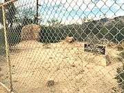
| The adobe ruins of one of two soldier barracks |
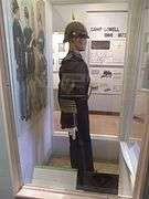
| Display of a sergeants uniform in the Fort Lowell Park Museum which once belonged to a member of the 5th Cavalry. |
| Reconstruction of Commanding Officer's Kitchen |
| The Quartermaster's Quarters |
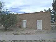
| The Fort Lowell Post Traders Store and "Riallito House" located at 5425 E. Fort Lowell Rd. |
| The Fort Lowell Quartermaster's Storehouse located at 5479 E. Fort Lowell Rd. |
| The San Pedro Chapel, also known as the San Pedro de Fort Lowell (St. Peter's at Fort Lowell Mission). |
| Second part of the previous plaque. |
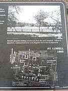
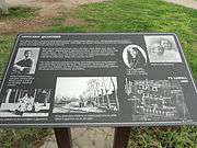
| First part of the interpretive plaque to the west of the post hospital. |
| Second part of the previous plaque. |
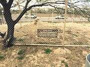
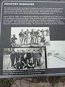
| First part of the infantry barracks interpretive plaque. |
| Middle part of the previous plaque. |
| Right half of the previous plaque. |
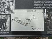
| Left half of Quartermaster information board. |
| Right half of Quartermaster information board. |
| Information board detailing statue. |
| Information board on officers' quarters. |
| The San Pedro Chapel National Register of Historic Places Marker. |
|
See also
References
- Schilling, Frank A. (June 1960). "Military Posts of the Old Frontier: Arizona - New Mexico". The Historical Society of Southern California Quarterly. University of California Press. 42 (2): 133–149. JSTOR 41169446.
External links
- Old Fort Lowell Neighborhood Association - Museum information and history
- Arizona Historical Society Museums
- Historic American Buildings Survey (HABS) No. AZ-17, "Fort Lowell, Fort Lowell Road Vicinity, Tucson, Pima County, AZ", 8 measured drawings, 7 data pages
- Historic American Buildings Survey (HABS) No. AZ-17-A, "Fort Lowell, Officers' Quarters, Fort Lowell Road Vicinity, Tucson, Pima County, AZ", 3 photos
- Historic American Buildings Survey (HABS) No. AZ-17-B, "Fort Lowell, Summer Kitchen, Fort Lowell Road Vicinity, Tucson, Pima County, AZ", 1 photo
- Historic American Buildings Survey (HABS) No. AZ-17-C, "Fort Lowell, Post Hospital (Ruins), Fort Lowell Road Vicinity, Tucson, Pima County, AZ", 5 photos
- Old Fort Lowell Neighborhood Association
Coordinates: 32°15′36″N 110°52′26″W / 32.26000°N 110.87389°W / 32.26000; -110.87389