Foster, Oklahoma
| Foster, Oklahoma | |
|---|---|
| Town | |
| Coordinates: 34°36′59″N 97°29′21″W / 34.61639°N 97.48917°WCoordinates: 34°36′59″N 97°29′21″W / 34.61639°N 97.48917°W | |
| Country | United States |
| State | Oklahoma |
| County | Garvin |
| Elevation | 974 ft (297 m) |
| Time zone | Central (CST) (UTC-6) |
| • Summer (DST) | CDT (UTC-5) |
| ZIP code | 73039 (historically), 73434 (today) |
| Area code(s) | 580 |
| GNIS feature ID | 1092974,[1] 2412646[1] |
Foster is a town in Garvin County, Oklahoma, United States. It was incorporated in 2002[2] and had an estimated population of 124 in 2007.[3]
Foster is served by State Highway 29A, a spur of State Highway 29. A post office was first established at Foster on August 12, 1891.[4]
Cemetery
There is a cemetery located at 34°36′14″N 97°29′38″W / 34.60389°N 97.49389°W.[1]
Geography
Foster is located at 34°36′59″N 97°29′21″W / 34.61639°N 97.48917°W (34.6164698, -97.4891933).[1]
Demographics
| Historical population | |||
|---|---|---|---|
| Census | Pop. | %± | |
| 2010 | 161 | — | |
| Est. 2015 | 162 | [5] | 0.6% |
References
- 1 2 3 4 "Geographic Names Information System". United States Geological Survey. Retrieved 2008-01-31.
- ↑ "Boundary Changes". Geographic Change Notes: Oklahoma. Population Division, United States Census Bureau. 2006-05-19. Retrieved 2008-07-13.
- ↑ "Table 4. Annual Estimates of the Population for Incorporated Places in Oklahoma: April 1, 2000 to July 1, 2007" (CSV). United States Census Bureau, Population Division. 2007-07-10. Retrieved 2008-07-13.
- ↑ OKGenWeb/USGenWeb Project - Garvin County, Oklahoma - Foster Postmasters
- ↑ "Annual Estimates of the Resident Population for Incorporated Places: April 1, 2010 to July 1, 2015". Retrieved July 2, 2016.
- ↑ "Census of Population and Housing". Census.gov. Retrieved June 4, 2015.
Municipalities and communities of Garvin County, Oklahoma, United States | ||
|---|---|---|
| Cities | 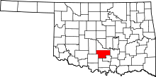 | |
| Towns | ||
| Unincorporated communities | ||
| Ghost town | ||
| Footnotes | ‡This populated place also has portions in an adjacent county or counties | |
This article is issued from Wikipedia - version of the 7/11/2016. The text is available under the Creative Commons Attribution/Share Alike but additional terms may apply for the media files.