Francis, Utah
| Francis, Utah | |
|---|---|
| Town | |
|
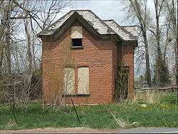
The Byron T. Mitchell House is listed on the National Register of Historic Places. | |
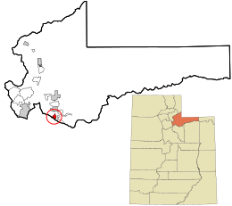 Location in Summit County and the state of Utah | |
| Coordinates: 40°36′52″N 111°16′44″W / 40.61444°N 111.27889°WCoordinates: 40°36′52″N 111°16′44″W / 40.61444°N 111.27889°W | |
| Country | United States |
| State | Utah |
| County | Summit |
| Settled | 1869 |
| Incorporated | 1939 |
| Founded by | John Williams |
| Named for | Francis M. Lyman |
| Area | |
| • Total | 1.8 sq mi (4.6 km2) |
| • Land | 1.8 sq mi (4.6 km2) |
| • Water | 0.0 sq mi (0.0 km2) |
| Elevation | 6,562 ft (2,000 m) |
| Population (2012) | |
| • Total | 1,120 |
| • Density | 390.2/sq mi (150.7/km2) |
| Time zone | Mountain (MST) (UTC-7) |
| • Summer (DST) | MDT (UTC-6) |
| ZIP code | 84036 |
| Area code(s) | 435 |
| FIPS code | 49-26940[1] |
| GNIS feature ID | 1428080[2] |
Francis is a town in Summit County, Utah, United States. It is part of the Salt Lake City, Utah Metropolitan Statistical Area. The population was 698 at the 2000 census.
Geography
According to the United States Census Bureau, the town has a total area of 1.8 square miles (4.7 km2), all of it land.
Demographics
| Historical population | |||
|---|---|---|---|
| Census | Pop. | %± | |
| 1910 | 184 | — | |
| 1920 | 234 | 27.2% | |
| 1930 | 226 | −3.4% | |
| 1940 | 345 | 52.7% | |
| 1950 | 276 | −20.0% | |
| 1960 | 252 | −8.7% | |
| 1970 | 268 | 6.3% | |
| 1980 | 371 | 38.4% | |
| 1990 | 381 | 2.7% | |
| 2000 | 698 | 83.2% | |
| 2010 | 1,077 | 54.3% | |
| Est. 2015 | 1,258 | [3] | 16.8% |
As of the census[1] of 2000, there were 698 people, 217 households, and 187 families residing in the town. The population density was 390.2 people per square mile (150.7/km2). There were 233 housing units at an average density of 130.3 per square mile (50.3/km2). The racial makeup of the town was 97.42% White, 0.29% African American, 0.29% Native American, 1.29% from other races, and 0.72% from two or more races. Hispanic or Latino of any race were 1.86% of the population.
There were 217 households out of which 47.9% had children under the age of 18 living with them, 75.1% were married couples living together, 10.1% had a female householder with no husband present, and 13.4% were non-families. 11.1% of all households were made up of individuals and 5.5% had someone living alone who was 65 years of age or older. The average household size was 3.22 and the average family size was 3.46.
In the town the population was spread out with 33.0% under the age of 18, 8.5% from 18 to 24, 31.8% from 25 to 44, 18.6% from 45 to 64, and 8.2% who were 65 years of age or older. The median age was 31 years. For every 100 females there were 96.6 males. For every 100 females age 18 and over, there were 95.0 males.
The median income for a household in the town was $55,536, and the median income for a family was $59,464. Males had a median income of $39,375 versus $26,354 for females. The per capita income for the town was $18,097. About 3.6% of families and 5.6% of the population were below the poverty line, including 8.3% of those under age 18 and 6.5% of those age 65 or over.
See also
References
- 1 2 "American FactFinder". United States Census Bureau. Retrieved 2008-01-31.
- ↑ "US Board on Geographic Names". United States Geological Survey. 2007-10-25. Retrieved 2008-01-31.
- ↑ "Annual Estimates of the Resident Population for Incorporated Places: April 1, 2010 to July 1, 2015". Retrieved July 2, 2016.
- ↑ "Census of Population and Housing". Census.gov. Retrieved June 4, 2015.
External links
 |
Hideout | Kamas | |
|
| Park City | |
Wasatch National Forest / Manila | ||
| ||||
| | ||||
| Midway, Heber City Daniel Wallsburg |
Independence | Wasatch National Forest / Tabiona |
Municipalities and communities of Summit County, Utah, United States | ||
|---|---|---|
| Cities | 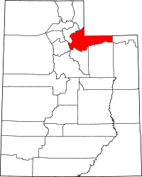 | |
| Towns | ||
| CDPs | ||
| Ghost towns | ||
| Footnotes | ‡This populated place also has portions in an adjacent county or counties | |