Franklin Furnace Historic District
|
Franklin Furnace Historic District | |
 | |
  | |
| Location | Roughly bounded by Circle Drive and Cinder Street, near Edenville, St. Thomas Township, Pennsylvania |
|---|---|
| Coordinates | 39°57′32″N 77°49′21″W / 39.95889°N 77.82250°WCoordinates: 39°57′32″N 77°49′21″W / 39.95889°N 77.82250°W |
| Area | 4 acres (1.6 ha) |
| Built | 1828 |
| Architectural style | Other, Iron furnace |
| MPS | Iron and Steel Resources of Pennsylvania MPS |
| NRHP Reference # | 91001136[1] |
| Added to NRHP | September 6, 1991 |
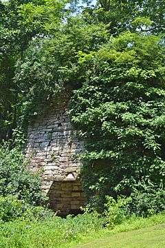
Franklin Furnace Historic District is a national historic district located in St. Thomas Township, Franklin County, Pennsylvania. The district includes five contributing buildings, one contributing structure, and one contributing site associated with a 19th-century iron furnace plantation. The buildings are the manager's house / office and four workers' houses. The structure is the furnace stack (1828). It measures 30 feet square at the base and approximately 30 feet tall. The contributing site is the ruins of a barn. The furnace ceased full operation in 1882.[2]
It was listed on the National Register of Historic Places in 1991.[1]
References
| Wikimedia Commons has media related to Franklin Furnace Historic District. |
- 1 2 National Park Service (2010-07-09). "National Register Information System". National Register of Historic Places. National Park Service.
- ↑ "National Historic Landmarks & National Register of Historic Places in Pennsylvania" (Searchable database). CRGIS: Cultural Resources Geographic Information System. Note: This includes Diane B. Reed (March 1991). "National Register of Historic Places Inventory Nomination Form: Franklin Furnace Historic District" (PDF). Retrieved 2012-02-04.
| Topics |   | |
|---|---|---|
| Lists by county |
| |
| Lists by city | ||
| Other lists | ||
| ||
This article is issued from Wikipedia - version of the 11/29/2016. The text is available under the Creative Commons Attribution/Share Alike but additional terms may apply for the media files.