Frettenham
| Frettenham | |
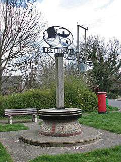 The village sign, incorporating a millstone from Frettenham Mill |
|
 Frettenham |
|
| Area | 6.33 km2 (2.44 sq mi) |
|---|---|
| Population | 740 (2011)[1] |
| – density | 117/km2 (300/sq mi) |
| OS grid reference | TG246174 |
| Civil parish | Frettenham |
| District | Broadland |
| Shire county | Norfolk |
| Region | East |
| Country | England |
| Sovereign state | United Kingdom |
| Post town | NORWICH |
| Postcode district | NR12 |
| Police | Norfolk |
| Fire | Norfolk |
| Ambulance | East of England |
| EU Parliament | East of England |
Coordinates: 52°42′31″N 1°19′25″E / 52.708531°N 1.323509°E
Frettenham is a civil parish in the English county of Norfolk. Known in the Domesday Book as 'Fretham', Frettenham is located six miles north-east of Norwich, surrounded by countryside. The village is well known for its rich farmland.[2] It covers an area of 6.33 km2 (2.44 sq mi) and had a population of 727 in 288 households at the 2001 census,[3] increasing slightly to a population of 740 in 307 households at the 2011 Census. For the purposes of local government, it falls within the district of Broadland.
The parish church of St Swithin dates from the 14th century; the chancel was rebuilt in 1869 by the architest Richard Phipson. [4]

See also
Notes
- ↑ "Civil Parish population 2011". Neighbourhood Statistics. Office for National Statistics. Retrieved 4 August 2016.
- ↑ Broadland and District Council- Frettenham. Retrieved 16 May 2010.
- ↑ Census population and household counts for unparished urban areas and all parishes. Office for National Statistics & Norfolk County Council (2001). Retrieved 20 June 2009.
- ↑ "Name: CHURCH OF ST SWITHIN List entry Number: 1372955". English Heritage. Retrieved 13 March 2014.
External links
![]() Media related to Frettenham at Wikimedia Commons
Media related to Frettenham at Wikimedia Commons
| Boroughs or districts | |
|---|---|
| Major settlements |
|
| Topics | |