Garlock Fault
The Garlock Fault is a left-lateral strike-slip fault running approximately northeast-southwest along the north margins of the Mojave Desert of Southern California. It runs for much of its length along the southern base of the Tehachapi Mountains.
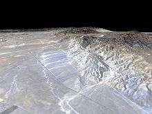
Geography
The Garlock Fault marks the northern boundary of the area known as the Mojave Block, as well as the southern ends of the Sierra Nevada and the valleys of the westernmost Basin and Range province. Stretching for 250 kilometers (160 mi), it is the second-longest fault in California and is one of the most prominent geological features in the southern part of the state.
The Garlock Fault runs from a junction with the San Andreas Fault in the Antelope Valley, eastward to a junction with the Death Valley Fault Zone in the eastern Mojave Desert. It is named after the historic mining town of Garlock, founded in 1894 by Eugene Garlock and now a ghost town.
Geology
The Garlock Fault is believed to have developed to accommodate the strain differential between the extensional tectonics of the Great Basin crust and the right lateral strike-slip faulting of the Mojave Desert crust.[1]
Unlike most of the other faults in California, slip on the Garlock Fault is left-lateral; that is, the land on the other side of the fault moves to the left from the perspective of someone facing the fault. In the case of the Garlock Fault, this means that the terrain north of the fault is moving westward relative to the terrain south of the fault, which is moving relatively eastward.
Activity
The Garlock Fault moves at a rate of between 2 and 11 mm a year, with an average slip of around 7 millimeters. While most of the fault is locked, certain segments have been shown to move by aseismic creep.
The Garlock is not considered to be a particularly active fault, seldom producing any shaking detectable by humans, although it has been known to generate sympathetic seismic events when triggered by other earthquakes and in one instance by the removal of ground water. These events, as well as continuing microearthquake activity and the state of the scarps from previous ruptures, do indicate that the Garlock will produce another major quake at some point in the future.[2]
The most recent notable event was a magnitude 5.7 near the town of Mojave on July 11, 1992. It is thought to have been triggered by the Landers earthquake, just two weeks earlier.
The last significant ruptures on the Garlock were thought to be in the years 1050 A.D. and 1500 A.D.. Research has pinned the interval between significant ruptures on the Garlock as being anywhere between 200 and 3000 years depending on the segment of the fault.[3]
Geography
The Garlock Fault constitutes one of the borders of the Mojave Desert, and is a significant geologic landmark in California. Mountain ranges mark its western edge, and its trace is clearly visible on aerial images of the state.
Relatively few communities lie directly along the Garlock, as it is primarily situated in the desert, with Frazier Park, Tehachapi, Mojave, and Johannesburg being the closest. However, a major rupture along the Garlock would probably be felt in most of the southern part of California.
References
- ↑ Classic Cordilleran Concepts. Department of Geology, University of Kansas. Retrieved 2008-08-10.
- ↑ Astiz, L.; Allen, C. R. (1983). "Seismicity of the Garlock fault, California". Bulletin of the Seismological Society of America. Seismological Society of America. pp. 1721–1734.
- ↑ Lin II, Rong-Gong (April 22, 2015). "The Big One could trigger series of large earthquakes, study finds". Los Angeles Times.
External links
- Southern California Earthquake Data Center: Faults in Southern California
- USGS Database: Garlock Fault