Mendocino Fracture Zone
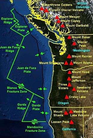
The Mendocino Fracture Zone is a fracture zone and transform boundary off the coast of Cape Mendocino in far northern California. It runs westward from a triple junction with the San Andreas Fault and the Cascadia subduction zone to the southern end of the Gorda Ridge. It continues on west of its junction with the Gorda Ridge, as an inactive remnant section which extends for several hundred miles.
Technically, a fracture zone is not a transform fault, but in the case of the Mendocino, the term has been loosely applied to the active fault segment east of the Gorda Ridge as well as to the true fracture zone segment west of it. Many seismologists refer to the active segment as the Mendocino Fault or Mendocino fault zone. The fault section demarcates the boundary between the northwestward-moving Pacific Plate and the eastward-moving Gorda Plate. The Gorda Plate is subducting beneath the North American Plate just offshore of Cape Mendocino. Where the Mendocino Fault intersects the undersea trench of the subduction zone, it also meets the San Andreas Fault. This seismically active intersection is called a triple junction, and specifically the Mendocino Triple Junction.
In Tsunami studies, energy focusing around the fracture zone has been noted, leading to increased wave heights in the area around Crescent City, California. The fracture zone is referred to as the Mendocino Escarpment in these studies, descriptively rather than named from its geological origin.[1]
History
Robert W. Pease observed in 1965 that the alignment of a transverse tectonic zone extending from Mount Lassen to the Walker Lane at the north end of Honey Lake Fault, suggests it was once the continental terminus of the Mendocino Fault. It forms the boundary of the Modoc Plateau and Columbia Plateau provinces with the Great Basin. Where it meets Honey Lake Fault, it bends to trend northeast across the northwest corner of Nevada, where it accompanies the geological trough that forms Black Rock Desert.[2]
See also
References
- ↑ Impact at Crescent City by distant scattering
- ↑ Pease, Robert W. (1965). Modoc County; University of California Publications in Geography, Volume 17. Berkeley and Los Angeles: University of California Press. pp. 8–9.
External links
- Mendocino Triple Junction Offshore Northern California
- Geology of the Cape Mendocino, Eureka, Garberville, and Southwestern part of the Hayfork 30 x 60 Minute Quadrangles and Adjacent Offshore Area, Northern California, USGS, 2000
- Cascadia tectonic history
Coordinates: 40°25′N 125°00′W / 40.417°N 125.000°W