Gatsibo District
| Gatsibo District | |
|---|---|
| District | |
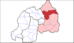 Shown within Eastern Province and Rwanda | |
| Country | Rwanda |
| Province | Eastern |
| Capital | Kabarore |
| Area | |
| • Total | 1,578 km2 (609 sq mi) |
| Population (2012 census) | |
| • Total | 433,020 |
| • Density | 270/km2 (710/sq mi) |
Gatsibo is a district (akarere) in Eastern Province, Rwanda. Its capital is Kabarore.
Geography
The district comprises areas in the north-east of Rwanda, between Kayonza and Nyagatare. The German post of Gatsibo was located here, as is the present-day Gabiro military camp. The eastern part of the district is in Akagera National Park, with the Kagera River forming the border with Tanzania.
Sectors
Gatsibo district is divided into 14 sectors (imirenge): Gasange, Gatsibo, Gitoki, Kabarore, Kageyo, Kiramuruzi, Kiziguro, Muhura, Murambi, Ngarama, Nyagihanga, Remera, Rugarama and Rwimbogo.
References
- "Districts of Rwanda". Statoids.
- Inzego.doc — Province, District and Sector information from MINALOC, the Rwanda ministry of local government.
Coordinates: 1°36′S 30°27′E / 1.600°S 30.450°E
This article is issued from Wikipedia - version of the 9/15/2015. The text is available under the Creative Commons Attribution/Share Alike but additional terms may apply for the media files.