Gausdal
| Gausdal kommune | |||
|---|---|---|---|
| Municipality | |||
| |||
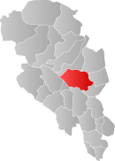 Gausdal within Oppland | |||
| Coordinates: 61°16′36″N 9°55′21″E / 61.27667°N 9.92250°ECoordinates: 61°16′36″N 9°55′21″E / 61.27667°N 9.92250°E | |||
| Country | Norway | ||
| County | Oppland | ||
| District | Gudbrandsdal | ||
| Administrative centre | Segalstad bru | ||
| Government | |||
| • Mayor (2011) | Hans Oddvar Høistad (Arbeiderpartiet) | ||
| Area | |||
| • Total | 1,192 km2 (460 sq mi) | ||
| • Land | 1,149 km2 (444 sq mi) | ||
| Area rank | 84 in Norway | ||
| Population (2004) | |||
| • Total | 6,186 | ||
| • Rank | 163 in Norway | ||
| • Density | 5/km2 (10/sq mi) | ||
| • Change (10 years) | -2.1 % | ||
| Demonym(s) | Gausdøl[1] | ||
| Time zone | CET (UTC+1) | ||
| • Summer (DST) | CEST (UTC+2) | ||
| ISO 3166 code | NO-0522 | ||
| Official language form | Neutral | ||
| Website |
www | ||
|
| |||


Gausdal is a municipality in Oppland county, Norway. It is part of the traditional region of Gudbrandsdal. The administrative centre of the municipality is the village of Segalstad bru. Follebu is a township and sub-parish in eastern Gausdal.
Logging, farming, and tourism are important occupations in the municipality.
General information
Name
The Old Norse form of the name was Gausdalr. The first element is the river name Gausa and the last element is dalr which means "valley" or "dale". The river name is derived from the verb gjósa which means "stream forcefully".[2]
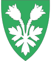
Coat-of-arms
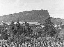
The coat-of-arms is from modern times. They were granted on 19 September 1986. The arms show the typical shape of one of the main mountains in the municipality, Skeikampen. [3][4]
History
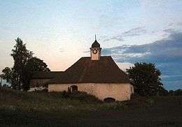
The Follebu stone church was built in the early Middle Ages (around 1250). It is unusual in that the chancel and nave were built as one continuous piece.
In the 1880s, there was mining for nickel in Espedalen. The search for nickel was taken up again in 2004 by Blackstone Venture, a Canadian company. As of 2006, they are still drilling for mineral samples only.
The municipality of Gausdal was established on 1 January 1838 (see formannskapsdistrikt). Gausdal was divided into the separate municipalities of Vestre Gausdal and Østre Gausdal in 1879, but they were reunited into one municipality in 1962.
Geography
Gausdal is bordered on the northwest by Sør-Fron municipality, on the northeast by Ringebu and Øyer, on the southeast by Lillehammer, on the south by Nordre Land, on the southwest by Nord-Aurdal and Øystre Slidre.
The famous Peer Gynt mountain road begins here and leads to Vinstra.
A popular ski area is located on the south slope of Skeikampen mountain.
Western tributaries of the Gudbrandsdalslågen include the Gausa River, which flows through Gausdal valley.
Norway's smallest national park, Ormtjernkampen National Park, lies within the municipality.
Notable residents
- Bjørnstjerne Bjørnson (1832–1910) was a Norwegian author and Nobel Prize in Literature winner in 1903. Aulestad in Follebu, Gausdal was his primary residence from 1874 until his death in 1910.
- Reidar Engjom - politician
- Brynhild Marie Foss - politician
- Iver Holter (1850–1941) was a composer and was conductor of the Bergen Philharmonic Orchestra from 1882 until 1886.
- Jan Erik Kristiansen - politician
- Inge Krokann (1893–1962) was a Norwegian writer who wrote dialect and idiosyncratic nynorsk works which are largely inaccessible to international readers but reputed to be very powerful, lived his later years and died in Gausdal.
- Else Kveine - poet
- Olav Olstad - politician
- Abraham Pihl - theologian, astronomer and architect
- Christen Smed - mountaineer
- Hans Aanrud (1863–1953) was a Norwegian writer who wrote plays, poetry, and stories depicting rural life in Norway.
- Ole Amundsen Buslett (1855–1924) - Norwegian-American author, newspaperman, and politician.
Sister cities
The following cities are twinned with Gausdal:[5]
-
 - Mora, Dalarna County, Sweden
References
- ↑ "Navn på steder og personer: Innbyggjarnamn" (in Norwegian). Språkrådet. Retrieved 2015-12-01.
- ↑ Rygh, Oluf (1900). Norske gaardnavne: Kristians amt (in Norwegian) (4 ed.). Kristiania, Norge: W. C. Fabritius & sønners bogtrikkeri. p. 183.
- ↑ Norske Kommunevåpen (1990). "Nye kommunevåbener i Norden". Retrieved 2008-12-30.
- ↑ "Om Gausdal" (in Norwegian). Gausdal kommune. Retrieved 2008-12-30.
- ↑ "Vennskapstreff i Mora" (in Norwegian). Gausdal kommune. Retrieved 2008-12-30.
External links
| Wikimedia Commons has media related to Gausdal. |
| Look up Gausdal in Wiktionary, the free dictionary. |
- Municipal fact sheet from Statistics Norway
 Oppland travel guide from Wikivoyage
- Gudbrandsdalen travel guide from Wikivoyage
- Tourist information
- Gausdølen - local newspaper (Norwegian)
- Art of the States: Bright Days of Little Sunlight musical work inspired by the mountains near Gausdal
|  | |||||||||||||||||||||||||||||||