Gaylord, Kansas
| Gaylord, Kansas | |
|---|---|
| City | |
 Location within Smith County and Kansas | |
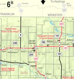 KDOT map of Smith County (legend) | |
| Coordinates: 39°38′43″N 98°50′49″W / 39.64528°N 98.84694°WCoordinates: 39°38′43″N 98°50′49″W / 39.64528°N 98.84694°W | |
| Country | United States |
| State | Kansas |
| County | Smith |
| Government | |
| • Type | Mayor–Council |
| • Mayor | David Tucker [1] |
| • City Clerk | Aubrey Neussendorfer [1] |
| Area[2] | |
| • Total | 0.25 sq mi (0.65 km2) |
| • Land | 0.25 sq mi (0.65 km2) |
| • Water | 0 sq mi (0 km2) |
| Elevation | 1,594 ft (486 m) |
| Population (2010)[3] | |
| • Total | 114 |
| • Estimate (2015)[4] | 109 |
| • Density | 460/sq mi (180/km2) |
| Time zone | Central (CST) (UTC-6) |
| • Summer (DST) | CDT (UTC-5) |
| ZIP code | 67638 |
| Area code | 785 |
| FIPS code | 20-26000 [5] |
| GNIS feature ID | 0472068 [6] |
| Website | City Website |
Gaylord is a city in Smith County, Kansas, United States. As of the 2010 census, the city population was 114.[7]
History
Gaylord was founded in 1870.[8] It was named for C. E. Gaylord, a native of Marshall County who was one of the town's founders.[8][9] The Gaylord post office opened in June 1871.[10]
Gaylord was a station on the Missouri Pacific Railroad.[11]
Geography
Gaylord is located at 39°38′43″N 98°50′49″W / 39.64528°N 98.84694°W (39.645229, -98.847008).[12] According to the United States Census Bureau, the city has a total area of 0.25 square miles (0.65 km2), all of it land.[2]
Demographics
| Historical population | |||
|---|---|---|---|
| Census | Pop. | %± | |
| 1880 | 231 | — | |
| 1890 | 314 | 35.9% | |
| 1900 | 302 | −3.8% | |
| 1910 | 308 | 2.0% | |
| 1920 | 356 | 15.6% | |
| 1930 | 291 | −18.3% | |
| 1940 | 245 | −15.8% | |
| 1950 | 231 | −5.7% | |
| 1960 | 239 | 3.5% | |
| 1970 | 211 | −11.7% | |
| 1980 | 203 | −3.8% | |
| 1990 | 173 | −14.8% | |
| 2000 | 145 | −16.2% | |
| 2010 | 114 | −21.4% | |
| Est. 2015 | 109 | [4] | −4.4% |
| U.S. Decennial Census | |||
2010 census
As of the census[3] of 2010, there were 114 people, 59 households, and 32 families residing in the city. The population density was 456.0 inhabitants per square mile (176.1/km2). There were 91 housing units at an average density of 364.0 per square mile (140.5/km2). The racial makeup of the city was 95.6% White, 0.9% African American, 0.9% Native American, and 2.6% from two or more races.
There were 59 households of which 18.6% had children under the age of 18 living with them, 44.1% were married couples living together, 3.4% had a female householder with no husband present, 6.8% had a male householder with no wife present, and 45.8% were non-families. 42.4% of all households were made up of individuals and 23.8% had someone living alone who was 65 years of age or older. The average household size was 1.93 and the average family size was 2.59.
The median age in the city was 52.3 years. 19.3% of residents were under the age of 18; 5.3% were between the ages of 18 and 24; 16.6% were from 25 to 44; 29.7% were from 45 to 64; and 28.9% were 65 years of age or older. The gender makeup of the city was 50.0% male and 50.0% female.
2000 census
As of the census[5] of 2000, there were 145 people, 72 households, and 43 families residing in the city. The population density was 571.1 people per square mile (223.9/km²). There were 96 housing units at an average density of 378.1 per square mile (148.3/km²). The racial makeup of the city was 95.86% White and 4.14% Native American. Hispanic or Latino of any race were 4.14% of the population.
There were 72 households out of which 23.6% had children under the age of 18 living with them, 55.6% were married couples living together, 4.2% had a female householder with no husband present, and 38.9% were non-families. 38.9% of all households were made up of individuals and 27.8% had someone living alone who was 65 years of age or older. The average household size was 2.01 and the average family size was 2.64.
In the city the population was spread out with 18.6% under the age of 18, 4.8% from 18 to 24, 20.0% from 25 to 44, 24.1% from 45 to 64, and 32.4% who were 65 years of age or older. The median age was 52 years. For every 100 females there were 79.0 males. For every 100 females age 18 and over, there were 81.5 males.
The median income for a household in the city was $21,250, and the median income for a family was $35,000. Males had a median income of $33,125 versus $15,313 for females. The per capita income for the city was $14,046. There were 8.3% of families and 17.8% of the population living below the poverty line, including 34.8% of under eighteens and 15.2% of those over 64.
Government
The Gaylord government consists of a mayor and five council members. The council meets the 2nd Wednesday of each month at 7:30PM.[1]
- City Hall, 509 Main Street.
References
- 1 2 3 Gaylord - Directory of Public Officials
- 1 2 "US Gazetteer files 2010". United States Census Bureau. Archived from the original on January 24, 2012. Retrieved 2012-07-06.
- 1 2 "American FactFinder". United States Census Bureau. Retrieved 2012-07-06.
- 1 2 "Annual Estimates of the Resident Population for Incorporated Places: April 1, 2010 to July 1, 2015". Retrieved July 2, 2016.
- 1 2 "American FactFinder". United States Census Bureau. Archived from the original on September 11, 2013. Retrieved 2008-01-31.
- ↑ "US Board on Geographic Names". United States Geological Survey. 2007-10-25. Retrieved 2008-01-31.
- ↑ "2010 City Population and Housing Occupancy Status". U.S. Census Bureau. Archived from the original on July 21, 2011. Retrieved April 25, 2011.
- 1 2 Kansas State Historical Society (1916). Biennial Report of the Board of Directors of the Kansas State Historical Society. Kansas State Printing Plant. p. 301.
- ↑ Gannett, Henry (1905). The Origin of Certain Place Names in the United States. Govt. Print. Off. p. 135.
- ↑ "Kansas Post Offices, 1828-1961". Kansas Historical Society. Archived from the original on October 9, 2013. Retrieved 23 June 2014.
- ↑ Blackmar, Frank Wilson (1912). Kansas: A Cyclopedia of State History, Embracing Events, Institutions, Industries, Counties, Cities, Towns, Prominent Persons, Etc. Standard Publishing Company. p. 714.
- ↑ "US Gazetteer files: 2010, 2000, and 1990". United States Census Bureau. 2011-02-12. Retrieved 2011-04-23.
External links
| Wikimedia Commons has media related to Gaylord, Kansas. |
- City
- Schools
- USD 237, local school district
- Maps
- Gaylord City Map, KDOT
Municipalities and communities of Smith County, Kansas, United States | ||
|---|---|---|
| Cities | 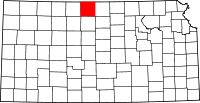 | |
| Unincorporated communities | ||