Geography of Washington, D.C.
Washington, D.C., in the United States, is located at 38°53′42″N 77°02′11″W / 38.89500°N 77.03639°W (the coordinates of the Zero Milestone, on the Ellipse). According to the United States Census Bureau, the city has a geographical area of 68.3 square miles (176.9 km2), 61.4 square miles (159.0 km2) of which is land, and the remaining 6.9 square miles (17.9 km2) (10.16%) of which is water.
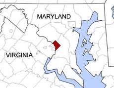
Washington is surrounded by the states of Virginia (on its southwest side) and Maryland (on its southeast, northeast, and northwest sides); it interrupts those states' common border, which is the south shore of the Potomac River both upstream and downstream from the District. The portion of the Potomac River that passes Washington is virtually entirely within the District's border, as the District extends to the south bank. The city contains the historic "federal city", the territory of which was formerly part of those two adjacent states before they respectively ceded it for the national capital. The land ceded from Virginia was returned by Congress in 1847, so what remains of the modern District was all once part of Maryland.
Topography and geology
The topography of the District of Columbia is very similar to the physical geography of much of Maryland. The District has three major natural flowing bodies of water: the Potomac River and two tributaries, the Anacostia River and Rock Creek. The confluence of the Potomac and Anacostia forms the historic peninsula known as Arsenal Point. The District also includes the Washington Channel, which flows into the junction of the Anacostia and Potomac rivers. There are also three man-made reservoirs: Dalecarlia Reservoir, which crosses over the northwest border of the District from Maryland, McMillan Reservoir near Howard University, and Georgetown Reservoir upstream of Georgetown. A fourth, minor reservoir is at Fort Reno in Tenleytown.
The highest point in the District of Columbia is 410 feet (125 m) above sea level at Reno Reservoir in Tenleytown.[1] The lowest point is sea level, which occurs along all of the Anacostia shore and all of the Potomac shore except the uppermost mile (the Little Falls-Chain Bridge area). The sea level Tidal Basin rose eleven feet during Hurricane Isabel on September 18, 2003. The geographic center of the District of Columbia is located near 4th Street NW, L Street NW, and New York Avenue NW, not under the Capitol dome as is sometimes stated. (The Capitol does mark the intersection of the District's four administrative quadrants.)
Other prominent geographical features of Washington, D.C., include Theodore Roosevelt Island, Columbia Island, the Three Sisters, and Hains Point.
Some areas, especially around the National Mall and parts of Foggy Bottom, were marshes or parts of the river that have been filled in.
Natural history
During the 18th century, significant portions of the region were forested, with species including rabbits, turkey, pheasants, woodcocks, turtles, and quail, as well as numerous bird species including mockingbirds, bluebirds, hummingbirds, and orioles. Other indigenous species include black snake, garter snake, rattle snake, copperhead, bullfrog and other types of frogs, ground squirrels, flying squirrels, skunks, opossums, raccoons, foxes, beavers, deer, wolves, and bears. Snipes and various types of ducks inhabited swampy areas, as well as soruses.[2]
Native tree species include willow, birch, cedar, and oak. Other plant species found along the Potomac during the early 19th century include yellow jessamine, prickly pear cactus, white horehound, sweet fennel, wild cherries, and wild strawberries.[2] The large percentage of parkland contributes to a high urban tree canopy coverage of 35%.[3]
In 1965, President Lyndon Johnson called the Potomac River a "national disgrace" and used the river to illustrate the need for the Clean Water Restoration Act of 1966.[4] The river is now home to a vibrant warm-water fishery and naturally reproducing bald eagles have returned to its banks.[5] Despite its intensely urbanized landscape, the District of Columbia is a center for research on urban wildlife management, invasive species management, urban stream restoration, and the aquatic ecology of urban streams.[6] The National Park Service's Center For Urban Ecology is a regional source of expertise and applied science for the region.[7]
Earthquakes
Earthquake activity in the District of Columbia is low. No earthquakes have been centered within the District, nor are there any faults. However it has felt earthquakes centered in Virginia, Maryland and other surrounding states, and also large earthquakes in Canada and New England.
The District felt the 1811-1812 New Madrid earthquakes, and according to old records, residents were "badly frightened". In March 1828, President John Quincy Adams felt a "violent" earthquake in the White House and wrote it in his journal. The 1886 Charleston earthquake (magnitude 6.6 to 7.3) was felt in DC. The strongest earthquake in Virginia happened in 1897 and was felt in the District. An earthquake in 1925 in Canada, estimated about magnitude 7, was felt over an area of 2 million square miles. Another 6.2 earthquake in 1935 caused damage in New York and shook residents from Maine to Wisconsin.[8]
The 2011 Virginia earthquake was felt (and caused damage) to landmarks and monuments in Washington such as the Washington Monument.
Climate
| Washington, DC | ||||||||||||||||||||||||||||||||||||||||||||||||||||||||||||
|---|---|---|---|---|---|---|---|---|---|---|---|---|---|---|---|---|---|---|---|---|---|---|---|---|---|---|---|---|---|---|---|---|---|---|---|---|---|---|---|---|---|---|---|---|---|---|---|---|---|---|---|---|---|---|---|---|---|---|---|---|
| Climate chart (explanation) | ||||||||||||||||||||||||||||||||||||||||||||||||||||||||||||
| ||||||||||||||||||||||||||||||||||||||||||||||||||||||||||||
| ||||||||||||||||||||||||||||||||||||||||||||||||||||||||||||
Washington, DC is located in the humid subtropical climate zone (Köppen climate classification: Cfa), exhibiting four distinct seasons.[9] Its climate is typical of the South. The District is located in USDA plant hardiness zone 8a near downtown, and zone 7b elsewhere in the city, indicating a temperate climate.[10] As implied in the previous sentence, the downtown area exhibits an urban heat island (UHI) build-up that can especially exacerbate the sultriness of summer nights.
- Winter sees sustained mild to cool temperatures, and the daily average temperature in January is 36.0 °F (2.2 °C). Rarely lows will be into the teens °F (−7 °C or below),[11] and temperatures below 10 °F (−12 °C) are rare, and the last 0 °F (−18 °C)-or-colder reading at Reagan National occurred on January 19, 1994.[12] In terms of highs, January alone sees 50 °F (10 °C)+ highs on 8.6 days, while 9 days per season stay at or below freezing.[11]
- Spring is typically dry, sunny, and begins in March. At Reagan National, the last freeze on average occurs on March 27.[11] Due to the rapid warming, pollen is also problematic during this time of year. Serious heat and humidity begin in late April to early May, although a drier heat is possible earlier. The first 90 °F (32 °C)+ high of the year on average falls on May 17.
- Summer is hot and humid, with July averaging 79.8 °F (26.6 °C). Nighttime conditions stay warm and are often humid, falling into the low 70s °F (21–23 °C). Dew points average from 62.4 to 66.3 °F (16.9 to 19.1 °C) from June to August as well, indicating moderate discomfort.[13] There are more than 35 days of 90 °F (32 °C) or higher temperatures, yet 100 °F (38 °C) temperatures do not occur every year. In recent years, due partly to increased UHI build-up, daily minima of 80 °F (27 °C) have become evermore common.[14]
- Autumn is similar to spring in temperature, with crisp mornings, and is a reasonably long transition, with the last 90 °F (32 °C)+ high of the year on average falling on September 10, and the first freeze at Reagan National occurring on November 18.[11]
- Precipitation is generous and well-distributed throughout the year (though February is noticeably drier), falling on 8 to 11 days per month, averaging 39.74 in (1,009 mm). Annual precipitation has ranged from 21.66 to 61.33 in (550 to 1,558 mm) in 1930 and 1889, respectively.[15] The wettest month on record was September 1934, with 17.45 in (443 mm) of rain, while the driest month was October 1963 with trace amounts.[16] The most rain in a calendar day was 6.39 in (162 mm) on August 23, 1933.
- Snowfall falls mostly in small accumulations, totaling an average 15.4 inches (39.1 cm) per season, occurring mostly in January and February, with some accumulation in December and March, but rarely November or April; on average there are 12.1 days per season with a snow depth of 1 in (2.5 cm) or more.[17] The strongest wintertime storms are usually "nor'easters", which typically feature high winds and heavy rains, occasionally in the form of a 'blizzard', while Alberta clippers are generally fast-moving and bring accumulations of under 4 in (10 cm).[18] The Knickerbocker Storm produced both the heaviest fall in a single storm, at 28 in (71 cm) and also the greatest 24-hour total of 21 in (53 cm); with an aggregate 56.1 in (142 cm), the snowiest season was 2009–10;[12] the most snow in one month was 35.2 in (89 cm) in February 1899.[19] The seasons with the least snow were 1972–73 and 1997–98 at 0.1 in (0.25 cm) each.[12] The earliest and latest dates for measurable (≥0.1 in or 0.25 cm) snowfall are October 10, 1979 and April 28, 1898, respectively. The suburbs to the north and west, due to a variety of factors (including inland location, elevation, and reduced UHI), typically receive more snowfall, with seasonal averages generally above 19 in (48 cm).[12] Freezing rain is also possible during the winter months; the location of the warm waters of the Gulf Stream to the east often causes the rain-snow line to be located in the region, and ice storms are more likely in January and February.
- During late summer and early fall, hurricanes, or their remnants, occasionally track through the area, though they have often weakened when doing so, partly due to the city's inland location. Flooding of the Potomac River, however, caused by a combination of high tide, storm surge, and runoff, has been known to cause extensive property damage in Georgetown.[20]
- Sunshine is adequate, totalling 2,529 hours per year, though from November through February bright sunshine is more likely to occur less than 50% of the time.
- Temperature extremes are as follows:
The highest recorded temperature was 106 °F (41 °C) on July 20, 1930, and August 6, 1918, while the lowest recorded temperature was −15 °F (−26 °C) on February 11, 1899, during the Great Blizzard of 1899.[18][21] The extreme low daily high temperature was 4 °F (−16 °C), occurring one day before the all-time minimum, while the extreme high daily low temperature was 84 °F (29 °C) on July 23–24, 2011 and July 16, 1983.[11] Monthly mean temperatures have ranged from 23.7 °F (−4.6 °C) in January 1918 to 84.5 °F (29.2 °C) in July 2011, while the corresponding range for the annual mean is 52.2 °F (11.2 °C) in 1904 to 61.5 °F (16.4 °C) in 2012.[lower-alpha 1]
| Climate data for Washington, D.C. (Reagan National Airport), 1981−2010 normals,[lower-alpha 2] extremes 1871−present[lower-alpha 3] | |||||||||||||
|---|---|---|---|---|---|---|---|---|---|---|---|---|---|
| Month | Jan | Feb | Mar | Apr | May | Jun | Jul | Aug | Sep | Oct | Nov | Dec | Year |
| Record high °F (°C) | 79 (26) |
84 (29) |
93 (34) |
95 (35) |
99 (37) |
104 (40) |
106 (41) |
106 (41) |
104 (40) |
96 (36) |
86 (30) |
79 (26) |
106 (41) |
| Mean maximum °F (°C) | 65.5 (18.6) |
67.5 (19.7) |
78.0 (25.6) |
85.8 (29.9) |
90.3 (32.4) |
95.2 (35.1) |
97.5 (36.4) |
96.5 (35.8) |
91.6 (33.1) |
83.7 (28.7) |
74.9 (23.8) |
66.4 (19.1) |
98.8 (37.1) |
| Average high °F (°C) | 43.4 (6.3) |
47.1 (8.4) |
55.9 (13.3) |
66.6 (19.2) |
75.4 (24.1) |
84.2 (29) |
88.4 (31.3) |
86.5 (30.3) |
79.5 (26.4) |
68.4 (20.2) |
57.9 (14.4) |
46.8 (8.2) |
66.8 (19.3) |
| Average low °F (°C) | 28.6 (−1.9) |
30.9 (−0.6) |
37.6 (3.1) |
47.0 (8.3) |
56.5 (13.6) |
66.3 (19.1) |
71.1 (21.7) |
69.7 (20.9) |
62.4 (16.9) |
50.6 (10.3) |
41.2 (5.1) |
32.5 (0.3) |
49.6 (9.8) |
| Mean minimum °F (°C) | 12.9 (−10.6) |
16.6 (−8.6) |
22.9 (−5.1) |
33.9 (1.1) |
44.6 (7) |
54.8 (12.7) |
62.1 (16.7) |
60.1 (15.6) |
49.7 (9.8) |
38.0 (3.3) |
28.7 (−1.8) |
18.2 (−7.7) |
9.9 (−12.3) |
| Record low °F (°C) | −14 (−26) |
−15 (−26) |
4 (−16) |
15 (−9) |
33 (1) |
43 (6) |
52 (11) |
49 (9) |
36 (2) |
26 (−3) |
11 (−12) |
−13 (−25) |
−15 (−26) |
| Average precipitation inches (mm) | 2.81 (71.4) |
2.62 (66.5) |
3.48 (88.4) |
3.06 (77.7) |
3.99 (101.3) |
3.78 (96) |
3.73 (94.7) |
2.93 (74.4) |
3.72 (94.5) |
3.40 (86.4) |
3.17 (80.5) |
3.05 (77.5) |
39.74 (1,009.4) |
| Average snowfall inches (cm) | 5.6 (14.2) |
5.7 (14.5) |
1.3 (3.3) |
trace | 0 (0) |
0 (0) |
0 (0) |
0 (0) |
0 (0) |
0 (0) |
0.5 (1.3) |
2.3 (5.8) |
15.4 (39.1) |
| Average precipitation days (≥ 0.01 in) | 9.6 | 9.0 | 10.5 | 10.4 | 11.1 | 10.7 | 10.3 | 8.2 | 8.3 | 7.7 | 8.6 | 9.7 | 114.1 |
| Average snowy days (≥ 0.1 in) | 3.0 | 2.4 | 0.9 | 0.1 | 0 | 0 | 0 | 0 | 0 | 0 | 0.2 | 1.5 | 8.1 |
| Average relative humidity (%) | 62.1 | 60.5 | 58.6 | 58.0 | 64.5 | 65.8 | 66.9 | 69.3 | 69.7 | 67.4 | 64.7 | 64.1 | 64.3 |
| Mean monthly sunshine hours | 144.6 | 151.8 | 204.0 | 228.2 | 260.5 | 283.2 | 280.5 | 263.1 | 225.0 | 203.6 | 150.2 | 133.0 | 2,527.7 |
| Percent possible sunshine | 48 | 50 | 55 | 57 | 59 | 64 | 62 | 62 | 60 | 59 | 50 | 45 | 57 |
| Source: NOAA (relative humidity and sun 1961−1990)[11][17][23][24] | |||||||||||||
| Climate data for Washington, D.C. (Reagan National, 1945-07-01–present) | |||||||||||||
|---|---|---|---|---|---|---|---|---|---|---|---|---|---|
| Month | Jan | Feb | Mar | Apr | May | Jun | Jul | Aug | Sep | Oct | Nov | Dec | Year |
| Record high °F (°C) | 79 (26) |
82 (28) |
89 (32) |
95 (35) |
99 (37) |
104 (40) |
105 (41) |
105 (41) |
101 (38) |
94 (34) |
86 (30) |
79 (26) |
105 (41) |
| Record low °F (°C) | −5 (−21) |
4 (−16) |
14 (−10) |
24 (−4) |
34 (1) |
47 (8) |
54 (12) |
49 (9) |
39 (4) |
29 (−2) |
16 (−9) |
3 (−16) |
−5 (−21) |
| Source: NOAA[11] | |||||||||||||
City plan
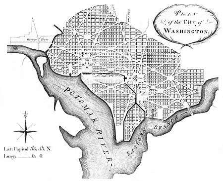
Washington, D.C., was created to serve as the national capital from its inception. The Residence Act of 1790 required that the capital's territory would be located along the Potomac River within an area that Maryland and Virginia would cede to the federal government, but permitted the nation's first president, George Washington to select the territory's precise location. President Washington then chose for the territory a square whose sides were 10 miles (16 km) in length and whose corners were directly north, east, south and west of its center. The area of the square contained the existing towns of Georgetown and Alexandria, as well as two small villages, Hamburgh in the Foggy Bottom area and Carrollsburg near the confluence of the Potomac and Anacostia Rivers.[25][26]
The Residence Act had granted the president the authority to locate the federal capital's territory only as far south and east as the mouth of the Anacostia River in Maryland. However, President Washington wanted to expand the territory's area southward so that its boundaries could encompass the town of Alexandria. In 1791, Congress amended the Residence Act to approve President Washington's selected site, which included the portion of the territory that Virginia would cede.[27]
The location of the capital had many natural advantages: the Potomac was navigable up to the territory, allowing for boat traffic; the established ports at Alexandria and Georgetown could provide an important economic base for a major city; and the territory's inland location was close to the Northwest Territory.[27] During 1791–1792, Andrew Ellicott and several assistants, including Benjamin Banneker, surveyed the boundary between the federal territory and the states of Virginia and Maryland, placing marker stones at every mile point (see Boundary Stones (District of Columbia)). Many of the stones are still standing.[28]
A new federal city, named in 1791 as the "City of Washington" in the "Territory of Columbia", was then laid out in a largely undeveloped area at the center of the 100 square mile federal territory. This city, which Pierre (Peter) L'Enfant designed, was bounded to the north by Boundary Street (now Florida Avenue) at the base of the escarpment of the Atlantic Seaboard Fall Line, to the southeast by the Anacostia River, to the southwest by the Potomac River and to the west by Rock Creek.[29][30] Although L'Enfant designed the city's original layout in 1791, surveyor Andrew Ellicott revised it in 1792 (see Streets and highways of Washington, D.C.).[29] The remainder of the territory was designated as Washington County (on the Maryland side of the Potomac) and Alexandria County (on the Virginia side).
Alexandria
The land from the State of Virginia was eventually returned to the state in 1846, effective 1847. This land in Virginia makes up the modern area of Arlington County and the old part of Alexandria, Virginia, both of which are considered suburbs of Washington. In fact, the Arlington National Cemetery and the Pentagon complex are both located in Arlington but are largely tied to the federal government in Washington. Between 1790 and 1846, Alexandria was referred to as "Alexandria, D.C."
Georgetown
Georgetown was originally part of Maryland and was the only significant population in the area that would become the District of Columbia. Georgetown became part of the District when the Federal City was first created, but remained an independent city, referred to as "Georgetown, D.C.," until 1871, when it was merged with Washington City and Washington County, completing the process of Washington and the District of Columbia occupying the same geographic borders.
McMillan plan
The monumental core of the city consists of the National Mall and many key federal buildings, monuments, and museums, including the Washington Monument, Lincoln Memorial, and the National Air and Space Museum. Its layout is based on that proposed by the McMillan Commission report in 1901.
Building heights
To preserve the grandeur of the National Mall, the White House, the Capitol, and various other key locations, the entire city is subject to strict building height limits. This limitation was placed in effect just prior to the 20th century when government officials realized that structural steel "skyscrapers" could overwhelm the city. In 1899, Congress enacted a height limit for the District prohibiting private buildings from rising more than 130 feet. Contrary to popular belief, no law has ever restricted buildings to the height of the United States Capitol or Washington Monument.[31][32]
A revised height law in 1910 did away with that fixed maximum. The newer legislation, still in effect today, states that no new building may be more than 20 feet taller than the width of the street in front of it.[33] The current law is codified as D.C. CODE ANN. § 6-601.05. Thus, Washington has a relatively modest skyline in comparison to the majority of American cities. However the District is ringed by high-rise buildings in many nearby suburbs like Arlington, Silver Spring, and Bethesda.
Neighborhoods
The District of Columbia is divided into eight wards and 37 Advisory Neighborhood Commissions (ANCs) within these wards. The total number of named neighborhoods is 127. The ANCs serve to advise the D.C. Council on neighborhood matters. The Council is required by law to give their opinions "great weight," though what that means is up to the Council to decide.
Since 2000 the demographics of many neighborhoods have changed markedly.
Adjacent communities
The District of Columbia is bordered by various cities, towns, villages, and unincorporated CDPs in the states of Maryland and Virginia. Following is a list of those adjacent communities.
- Hillcrest Heights, Maryland
- Mount Rainier, Maryland
- Seat Pleasant, Maryland
- Silver Hill, Maryland
- Silver Spring, Maryland
- Suitland, Maryland
- Takoma Park, Maryland
- Alexandria, Virginia
- Arlington, Virginia
- McLean, Virginia (touches Washington, D.C. at one corner only)
In addition to the above named places, there are other small unincorporated parts of Prince George's County, Maryland which also border the District.
See also
| Wikimedia Commons has media related to Geography of Washington, D.C.. |
- List of Circles in Washington, D.C.
- Streets and highways of Washington, D.C.
- Quadrants of Washington, D.C.
- Tiber Creek
Notes
- ↑ The latter figure bested the previous record-holder, 1991, by 1.3 °F (0.7 °C), a very wide margin over a year.
- ↑ Mean monthly maxima and minima (i.e. the expected highest and lowest temperature readings at any point during the year or given month) calculated based on data at said location from 1981 to 2010.
- ↑ Official records for Washington, D.C. were kept at 24th and M Streets NW from January 1871 to June 1945, and at Reagan National since July 1945.[22]
References
- ↑ "Elevations and Distances in the United States". United States Geological Society. United States Department of the Interior. 2001. Archived from the original on July 22, 2012.
- 1 2 McAtee, Waldo Lee (1918). A Sketch of the Natural History of the District of Columbia. H.L. & J.B. McQueen. pp. 7–9.
- ↑ "Planting trees to increase the urban tree canopy in Washington, D.C.". The Washington Post. April 30, 2010. Retrieved 2010-04-30.
- ↑ "Potomac Basin History". Interstate Commission on the Potomac River Basin. 2002-04-01. Archived from the original on 2008-05-27. Retrieved 2008-06-02.
- ↑ Shogren, Elizabeth (2007-03-14). "Eagle Population Up, But Prime Habitat Threatened". National Public Radio. Retrieved 2008-06-10.
- ↑ "Environmental Resources". D.C. Department of the Environment. Retrieved 2008-06-03.
- ↑ "Center for Urban Ecology". National Park Service. Retrieved 2008-05-27.
- ↑ "District of Columbia: Earthquake History". Retrieved January 19, 2013.
- ↑ "World Map of the Köppen-Geiger climate classification updated". University of Veterinary Medicine Vienna. 2008-11-06. Retrieved 2009-12-03.
- ↑ "Hardiness Zones". Arbor Day Foundation. 2006. Retrieved 2008-11-04.
- 1 2 3 4 5 6 7 "NowData - NOAA Online Weather Data". National Oceanic and Atmospheric Administration. Retrieved 2016-04-17.
- 1 2 3 4 "NWS Sterling, VA - Snowfall and Cold". National Oceanic and Atmospheric Administration. Retrieved 2012-06-30.
- ↑ "Weatherbase: Historical Weather for Washington, DC, US". Weatherbase. Retrieved 7 September 2016.
- ↑ Livingston, Ian (2011-07-21). "The highest low temperatures in Washington, D.C.: A look at 80F+ overnight readings". Retrieved 2013-06-06.
- ↑ Washington D.C. Precipitation
- ↑ WASHINGTON NATIONAL AIRPORT NORMALS, MEANS, AND EXTREMES
- 1 2 "Station Name: VA WASHINGTON REAGAN AP". National Oceanic and Atmospheric Administration. Retrieved 2014-03-13.
- 1 2 Watson, Barbara McNaught (1999-11-17). "Washington Area Winters". National Weather Service. Archived from the original on January 8, 2015. Retrieved 2008-06-03.
- ↑
- ↑ Vogel, Steve (2006-06-28). "Bulk of Flooding Expected in Old Town, Washington Harbour". The Washington Post. p. B02. Retrieved 2008-07-11.
- ↑ "Monthly Averages for Washington, DC – Temperature and Precipitation". The Weather Channel. Retrieved 2009-08-30.
- ↑ "Threaded Station Extremes". threadex.rcc-acis.org.
- ↑ "WMO Climate Normals for WASHINGTON DC/NATIONAL ARPT VA 1961–1990". National Oceanic and Atmospheric Administration. Retrieved 2016-09-07.
- ↑ Rogers, Matt (1 April 2015). "April outlook: Winter be gone! First half of month looks warmer than average". The Washington Post. Retrieved 4 May 2015.
- ↑ Faethz, E.F.M.; Pratt, F.W. (1874). "Sketch of Washington in embryo, viz: Previous to its survey by Major L'Enfant: Compiled from the rare historical researches of Dr. Joseph M. Toner ... combined with the skill of S.R. Seibert C.E.". Map in the collection of the Library of Congress. Encyclopædia Britannica Online. Retrieved 2012-04-03.
- ↑ "Hamburgh on the Potomac". Archived from the original on 2009-10-25.
- 1 2 Crew, Harvey W.; William Bensing Webb; John Wooldridge (1892). Centennial History of the City of Washington, D. C. Dayton, Ohio: United Brethren Publishing House. pp. 89–92.
- ↑ "Boundary Stones of Washington, D.C.". BoundaryStones.org. Retrieved 2008-05-27.
- 1 2 Passanneau, Joseph R. (2004). Washington Through Two Centuries: A History in Maps and Images. New York: The Monacelli Press, Inc. pp. 14–16, 24–27. ISBN 1-58093-091-3.
- ↑ "The L'Enfant and McMillan Plans". National Park Service. Retrieved May 27, 2008.
- ↑ Gilmore, Matthew (2007). "H-DC / Building Height Timeline". Humanities & Social Sciences Online. Retrieved 2009-10-14.
- ↑ Government Printing Office, United States (1916). Report of the Join Select Committee of the Congress of the United States Pursuant to Public Act 268. 1. United States Government Printing Office. p. 863.
- ↑ Livingston, Mike (February 13, 2003). "D.C.'s height limits: Taking the measure of their impact". Washington Business Journal. Retrieved 2006-07-01.
External links
| Topics | |
|---|---|
| Politics | |
| Society | |
| Government | |