Glacial erratic boulders of Kitsap County, Washington
Glacial erratic boulders of Kitsap County are large glacial erratic boulders of rock which were moved into Kitsap County, Washington by glacial action during previous ice ages.
Kitsap County was so extensively formed by glaciation that according to J Harlen Bretz almost any east-west traverse across the Kitsap Peninsula (shared with two other counties) will describe an ascending and descending profile across till ridges.[1]
List of boulders
| Frog Rock, dynamited, moved off road, and stacked in 20th century |  |
| Haleets, at Agate Point on Bainbridge Island, has petroglyphs said to be from before 400 CE | 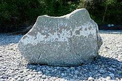 |
| Illahee Preserve erratic
At Illahee Preserve Almira parking lot[2] |
|
| Illahee Road erratic, an "extremely large erratic of volcanic rock"[3] |
References
- ↑ Bretz, J Harlen (1913), Glaciation of the Puget Sound Region (PDF), Washington Geological Survey, p. 220
- ↑ Illahee Preserve Stewardship Committee (February 23, 2015), Illahee Preserve Stewardship Plan (revised working draft) (PDF)
- ↑ Sceva, Jack E. (1957), "Geology and Ground-Water Resources of Kitsap County Washington" (PDF), Water-Supply Paper 1413, U.S. Geological Survey, p. 22
External links
- Washington glacial erratics project at University of Washington dept. of earth and space sciences
Glacial erratics in Washington state | ||||||||
|---|---|---|---|---|---|---|---|---|
| Puget Sound |
|  | ||||||
| Elsewhere | ||||||||
| ||||||||
This article is issued from Wikipedia - version of the 5/29/2016. The text is available under the Creative Commons Attribution/Share Alike but additional terms may apply for the media files.