Gladstone, Oregon
| Gladstone | ||
|---|---|---|
| City | ||
| Gladstone, Oregon | ||
|
Fire and police station, located in Gladstone's downtown | ||
| ||
| Motto: Home of the Pow Wow Tree | ||
 Location in Oregon | ||
| Coordinates: 45°22′52″N 122°35′35″W / 45.38111°N 122.59306°WCoordinates: 45°22′52″N 122°35′35″W / 45.38111°N 122.59306°W | ||
| Country | United States | |
| State | Oregon | |
| County | Clackamas | |
| Incorporated | 1911 | |
| Government | ||
| • Mayor |
Tom Mersereau (acting mayor)[1] | |
| Area[2] | ||
| • Total | 2.48 sq mi (6.42 km2) | |
| • Land | 2.40 sq mi (6.22 km2) | |
| • Water | 0.08 sq mi (0.21 km2) | |
| Elevation | 57 ft (17 m) | |
| Population (2010)[2] | ||
| • Total | 11,491 | |
| • Estimate (2015)[2][3] | 11,986 | |
| • Density | 4,790.4/sq mi (1,849.6/km2) | |
| Time zone | Pacific (UTC-8) | |
| • Summer (DST) | Pacific (UTC-7) | |
| ZIP code | 97027 | |
| Area code(s) | 503 | |
| FIPS code | 41-29000[2] | |
| GNIS feature ID | 1136316[4] | |
| Website | City of Gladstone | |


Gladstone is a city located in Clackamas County, Oregon, United States. The population was 11,491 at the 2010 census. Gladstone is an approximately 4-square-mile (10 km2) suburban community, 12 miles (19 km) south of Portland, the largest city in Oregon, and located at the confluence of the Clackamas and Willamette rivers.[5]
Gladstone has held several important cultural and social events, hosting both the inaugural Clackamas County Fair and the Oregon State Fair, before both were moved to more spacious locations.[6][7] Both Secretary of State William Jennings Bryan and presidential candidate Theodore Roosevelt have given public speeches in the city.[8]
History
Clackamas Indians
Prior to European settlement, there were several Native American groups living in the area that was to become Gladstone.[9]
In 1804, President Thomas Jefferson commissioned the Lewis and Clark expedition to explore the Louisiana Territory and beyond.[10] Although the expedition passed only near the Gladstone – Oregon City locality on their way to and from the Pacific Ocean, via the Columbia River, natives such as the Kalapuya and the Clackamas people told them about the area.[11]
In the subsequent years, successive waves of explorers and traders would introduce epidemics of cholera and smallpox, which would take a heavy toll on the native peoples and contributed to a substantial reduction in population.[9]
As Oregon City was founded and European settlers began moving to the area, they petitioned their governments to remove the local natives from the land, so that the settlers could use it for farming and housing. The government allocated a reservation for the natives and re-appropriated Gladstone for redevelopment.[12]
As of 2014, the only extant remnant of the bygone natives is a large maple tree called the "Pow Wow Tree", which is listed as an Oregon Heritage Tree.[13] The tree still stands at Clackamas Boulevard, and is said to have marked the place where the different native tribes, mainly Clackamas and Multnomahs, met to make trading agreements, settle community affairs, and conduct wedding ceremonies. In 1860, the Pow-Wow Tree was the location set for the first Clackamas County Fair. The following year, it was used as a parade ring for the first Oregon State Fair and marked the entrance. In 1937, the tree itself was celebrated with the Gladstone Pow-Wow Festival.[8]
Early homesteaders
The earliest homesteads in the area were recipients of the Donation Land Claim Act. The Cason and the Rinearson families were the first settlers to receive their donation land claims in Gladstone. Peter M. Rinearson and his family owned the land between Jennings Lodge and the Clackamas River, and between the Willamette River and Portland Avenue.[8] Fendal Cason, who came to Oregon in 1843 and would go on to serve on in the Oregon Territorial Legislature, owned an area of equal in size east of Portland Avenue.[14]
Unsuccessful early townships
Before Gladstone was formally founded, several small settlements were established in its vicinity. However, due to various natural disasters, such as fires and floods, few survived to become incorporated cities of today.
One such community was Linn City (originally named Robin’s Nest). Settled in 1843 by Robert Moore, Robert himself built four flour and lumber mills along the banks of the Willamette. Warehouses, homes, and mills were steadily added until 1861, when a fire destroyed several of the buildings. Efforts at rebuilding the small town entirely ceased when the Great Flood of 1862 struck, wiping out the remaining buildings.[15][16]
Another such ill-fated settlement was Canemah, located near the Willamette Falls. Canemah prospered until 1861, when the same great flood swept most of the town over the falls. Even after reconstruction, much of the town's importance to river commerce ended in 1873 with completion of the Willamette Falls Locks. Ships no longer needed to dock and unload goods and passengers for portage around the falls. The remaining town officially survived until 1929, when it was annexed to Oregon City.[17]
Founding of Gladstone

Gladstone was founded by Judge Harvey Cross in 1889, and formally incorporated on January 10, 1911. It was named after the British statesman William Ewart Gladstone.[18] Judge Cross laid out the city's first streets. Cross' home was built in the late 1840s by Fendal Cason, and Cross purchased it in 1862.[19] The Cason-Cross House later became Cochran Mortuary. Currently, Mr. Rooter, a plumbing service, occupies the space.[19] There is also a small park named after Cross, located at the same place one of the Indian tribes made its camp.[20]
Chautauqua movement
In 1894, the Chautauqua movement made its way to Gladstone. Judge Cross established a fifty-year lease of Gladstone Park for this event after he was convinced by Oregon City author Eva Emery Dye that doing so would be a boon to the city and its people. Beginning on July 24–26, 1894, the newly formed Willamette Valley Chautauqua Association held an annual summer assembly that offered performances, lectures, and concerts.[21] This event would reoccur annually, until Gladstone's Chautauqua Park grew to be the third-largest permanent Chautauqua assembly park in the United States.[22]
In 1896, William Jennings Bryan drew a crowd of 6,000 to Gladstone’s then 78-acre Chautauqua park to hear him give his popular lecture, “The Prince of Peace”, which stressed that Christian theology, through both individual and group morality, was a solid foundation for peace and equality.[23][24]
With the advent of radio, improved transportation and the appearance of traveling vaudeville acts in Portland, attendance at the Chautauqua began to dwindle. In 1927, the Willamette Valley Chautauqua Association went bankrupt. Judge Cross died on August 7, 1927, and shortly thereafter, Gladstone Park, including its buildings and Chautauqua Lake, were sold to the Western Oregon Conference of Seventh-day Adventists.[22]
Geography
According to the United States Census Bureau, the city has an official area of 2.48 square miles (6.42 km2).[2]
Adjacent communities
The city of Gladstone is immediately bordered by the following communities, listed in descending order of population:[5]
- Oregon City, the county seat of Clackamas County, sits to the south, almost entirely separated by the Clackamas River
- West Linn, to the west, is delineated by the Willamette River.
- Oak Grove, a census-designated place and unincorporated area, abuts Lake Oswego to the west, Milwaukie to the north, and Jennings lodge to the south.
- Jennings Lodge, a census-designated place and unincorporated area, runs between Oak Grove and Gladstone.
- Oatfield, a census-designated place and unincorporated area similar to Jennings Lodge, exists between Milwaukie, to the north, and Gladstone, to the south.
- Clackamas, to the northeast, an unincorporated area and former census-designated place, resides within greater Clackamas County.
- Johnson City, a very small incorporated city of approximately 500 residents, is northeast of Gladstone. (See also the similar city of Maywood Park, Oregon.) In 1968, the 45-acre (18 ha) city tried unsuccessfully to annex to Gladstone.[25]
Although the above cities are generally considered part of the much larger Portland metropolitan area, Gladstone, Oregon City, West Linn, and Milwaukie each possess the population and production of a micropolis in their own right and this relatively dense sub-region contains a combined population exceeding 100,000 people.[26]
Despite the Gladstone's proximity to the city of Milwaukie, at no point do the two share political boundaries.[5]
Major thoroughfares and street grid
Being bordered by rivers on two sides, there are only two primary thoroughfares to and from the city. Interstate 205 runs north-south along the eastern edge of the city, while McLoughlin Boulevard (Oregon Route 99E) runs north-south through the western side.[5]
Taken at the suggestion of surveyor Sidney Smyth, Judge Harvey Cross decided to name a number of Gladstone streets after American colleges (e. g. University of California, Berkeley, Cornell University) and a number of United Kingdom dukes, earls, and universities (.e.g. University of Exeter, Earl of Dartmouth, Earl of Clarendon).[21] Portland Avenue, Gladstone’s main street, is the only divergence from this naming convention. Named for the 1893 Interurban Electric Streetcar line that once traversed the street, it once transported passengers to and from Gladstone to Portland.[21]
Climate
The annual average temperature for Gladstone is 54.4 °F (12.4 °C), while the annual average precipitation is 46.3 inches (1,180 mm). According to the Köppen Climate Classification system, Gladstone has a warm-summer Mediterranean climate, abbreviated "Csb" on climate maps.[27]
Demographics
| Historical population | |||
|---|---|---|---|
| Census | Pop. | %± | |
| 1920 | 1,069 | — | |
| 1930 | 1,348 | 26.1% | |
| 1940 | 1,629 | 20.8% | |
| 1950 | 2,434 | 49.4% | |
| 1960 | 3,854 | 58.3% | |
| 1970 | 6,254 | 62.3% | |
| 1980 | 9,500 | 51.9% | |
| 1990 | 10,152 | 6.9% | |
| 2000 | 11,438 | 12.7% | |
| 2010 | 11,497 | 0.5% | |
| Est. 2015 | 11,986 | [28] | 4.3% |
| Sources:[29][30][31][32][33] | |||
As of the census of 2010, there were 11,497 people, 4,540 households, and 3,009 families residing in the city. The population density was 4,790.4 inhabitants per square mile (1,849.6/km2). There were 4,779 housing units at an average density of 1,991.3 per square mile (768.8/km2). The racial makeup of the city was 89.2% White, 0.9% African American, 1.0% Native American, 1.6% Asian, 0.4% Pacific Islander, 3.4% from other races, and 3.6% from two or more races. Hispanic or Latino of any race were 8.7% of the population.[2]
Arts and culture
The annual Gladstone Cultural Festival and parade in early August commemorates Gladstone's former status as a popular Chautauqua destination. The festival is held in Max Patterson Memorial City Park.[34] Despite its relatively small geographic size, The city of Gladstone recognizes 17 separate parks and recreational areas.[20]
KRYP is a Spanish language FM radio station that broadcasts from the city.[35]
Public services

Public safety and quality of life
Some polling data suggests that Gladstone citizens are satisfied with city services they receive and a large majority consider Gladstone a particularly "good/excellent" place to live.[36][37] Perhaps reflecting this support, the police, fire, and medical services levy renewal measures were overwhelmingly approved by voters in November 2012.[38][39][40]
Education

Schools
Gladstone is served by the Gladstone School District, which includes John Wetten Elementary School, Kraxberger Middle School, and Gladstone High School. In 2006, a bond was passed to allow approximately $40 million worth of construction on the three schools.[41] The majority (approx. 26 million) of the money was applied towards a remodel of the high school.[41] The district later refinanced the bond, saving taxpayers over 5 percent on its total ($805,040), with savings to begin in the 2024 tax year.[42]
Library
The city operates a library that is part of the Library Information Network of Clackamas County. In 2012, the city council approved plans for a new $10 million library, but ballot measures backed by the group Save Gladstone blocked the financing and construction pending specific voter approval.[43][44] The city then placed a new measure on the November 2014 ballot for a $6.4 million option.[45]
Public transit
Gladstone is within the TriMet transportation district, and transit service in the city is provided by TriMet bus routes 32-Oatfield,[46] 33-McLoughlin/King Road,[47] 34-Linwood/River Road,[48] and 79-Clackamas/Oregon City,[49] as well as rush-hour express route 99-Macadam/McLoughlin.
Notable people
American labor activist Liz Shuler grew up in Gladstone. She went on to become Secretary-Treasurer of the AFL-CIO.[50][51] She is the first woman and (as of 2009) the youngest person to hold the position of Secretary-Treasurer.[50][52]
References
- ↑ Rendleman, Raymond (January 27, 2016). "Dominick Jacobellis resigns as Gladstone mayor". Portland Tribune. Retrieved February 2, 2016.
- 1 2 3 4 5 6 "US Gazetteer files 2010". United States Census Bureau. Retrieved 2014-09-08.
- ↑ "Population Estimates". United States Census Bureau. Retrieved 2015-08-06.
- ↑ "US Board on Geographic Names". United States Geological Survey. 2007-10-25. Retrieved September 10, 2014.
- 1 2 3 4 "Oregon Transportation Map for the City of Gladstone" (PDF). Oregon.gov. 2013. Retrieved 10 September 2014.
- ↑ "History". Official Clackamas County Fair and Rodeo website. Retrieved 10 September 2014.
- ↑ "Oregon State Fair". Special Collections & Archives Research Center - Oregon State University Libraries. August 31, 2011. Retrieved 10 September 2014.
- 1 2 3 "GLADSTONE HISTORY". City of Gladstone official website. Retrieved 10 September 2014.
- 1 2 "Brief History of Oregon City". Official City of Oregon City website. 2000. Retrieved 10 September 2014.
- ↑ Lewis, Meriwether; Clark, William (2004). The Journals Of Lewis And Clark. Kessinger Publishing. p. 312. ISBN 9781419167997.
- ↑ "The journals of the Lewis and Clark expedition". University of Nebraska Lincoln. Retrieved January 16, 2014.
- ↑ Kohnen, Patricia. "The Clackamas Chinook people". http://www.usgennet.org/. Retrieved 10 September 2014. External link in
|website=(help) - ↑ "Pow-Wow Tree". Oregon Travel Experience. Retrieved September 8, 2014.
- ↑ Flora, Stephanie (2004). "Captains of 1843". Emigrants to Oregon in 1843. Retrieved September 10, 2014.
- ↑ Thomas, Mike (October 23, 2009). "Linn City: A Victim of Nature's Wrath". U.S. Department of the Interior – Bureau of Land Management. Retrieved September 10, 2014.
- ↑ "Linn City". portlandhistory.net. January 20, 2013. Retrieved 10 September 2014.
- ↑ Hedges, David. "Canemah". The Oregon Encyclopedia. Retrieved 10 September 2014.
- ↑ McArthur, Lewis A.; McArthur, Lewis L. (2003). Oregon Geographic Names. Portland: Oregon Historical Society Press. p. 404. ISBN 0-87595-278X.
- 1 2 "Historical society plans to feed minds, bellies". The Oregonian. August 20, 2008. Retrieved December 16, 2008.
- 1 2 "Parks & Recreation Information" (PDF). Official City of Gladstone Website. Retrieved 10 September 2014.
- 1 2 3 "History of Gladstone Part 2". Gladstone Historical Society. Retrieved January 20, 2015.
- 1 2 "History of Gladstone Part 4". Gladstone Historical Society. Retrieved January 20, 2015.
- ↑ Schwantes, Carlos (1989). The Pacific Northwest: An Interpretive History. p. 281. ISBN 0803292287.
- ↑ Bryan, William James. "The Prince of Peace". http://thriceholy.net. Retrieved 23 January 2015. External link in
|website=(help) - ↑ McArthur, Lewis A.; McArthur, Lewis L. (2003) [1928]. Oregon Geographic Names (7th ed.). Portland, Oregon: Oregon Historical Society Press. p. 515. ISBN 978-0875952772.
- ↑ Orzag, Peter (December 1, 2009). "Update of Statistical Area Definitions and Guidance on Their Uses" (PDF). Executive Office of the President – Office of Management and Budget. Retrieved September 11, 2014.
- ↑ "Climate Summary for Gladstone, Oregon". Weatherbase. Retrieved December 23, 2014.
- ↑ "Annual Estimates of the Resident Population for Incorporated Places: April 1, 2010 to July 1, 2015". Retrieved July 2, 2016.
- ↑ "Population-Oregon" (PDF). U.S. Census 1910. U.S. Census Bureau. Retrieved 22 November 2013.
- ↑ "Population-Oregon" (PDF). 15th Census of the United States. U.S. Census Bureau. Retrieved 27 November 2013.
- ↑ "Number of Inhabitants: Oregon" (PDF). 18th Census of the United States. U.S. Census Bureau. Retrieved 22 November 2013.
- ↑ "Pennsylvania: Population and Housing Unit Counts" (PDF). U.S. Census Bureau. Retrieved 22 November 2013.
- ↑ "Gladstone (city), Oregon". U.S. Census Bureau. Retrieved 7 September 2013.
- ↑ Christensen, DJ. "Gladstone Cultural Festival". Promotional website for the Gladstone Cultural Festival. Retrieved 12 September 2014.
- ↑ "KRYP-FM 93.1 MHz". radio-locator. Theodric Technologies LLC. Retrieved 10 March 2012.
- ↑ "Moore Information: opinion research - strategic analysis" (PDF). http://www.ci.gladstone.or.us. 2008. Retrieved 4 September 2014. External link in
|website=(help) - ↑ "Moore Information: opinion research - strategic analysis" (PDF). http://www.ci.gladstone.or.us. 2010. Retrieved 7 September 2014. External link in
|website=(help) - ↑ "Gladstone City Police Services Levy Renewal Measure (November 2012)". Ballotpedia. Retrieved 4 September 2014.
- ↑ "Gladstone Fire and Medical Services Operating Levy Measure (November 2012)". Ballotpedia. Retrieved 4 September 2014.
- ↑ Edwards, Victoria (November 6, 2012). "Gladstone voters approve renewal of police and fire levies". Oregonlive. Retrieved 4 September 2014.
- 1 2 "Questions and Answers about the Gladstone School Bond" (PDF). www.gladstone.k12.or.us. Archived from the original (PDF) on August 8, 2007. Retrieved September 12, 2014.
- ↑ "Gladstone Schools refinances bonds, saving taxpayers thousands". www.gladstone.k12.or.us. Retrieved January 22, 2015.
- ↑ Edwards, Victoria (3 October 2012). "Meet the measure: Gladstone 3-413 will decide fate of new library". The Oregonian. Retrieved 3 October 2012.
- ↑ "Gladstone City Library Bond Measure (November 201". Ballotpedia. Retrieved 4 September 2014.
- ↑ Bamesberger, Michael (October 15, 2014). "Gladstone seeks voter approval to move forward with new, scaled-down library plan". The Oregonian. Retrieved 16 October 2014.
- ↑ "32-Oatfield". TriMet. Retrieved 2015-11-21.
- ↑ "33-McLoughlin/King Rd". TriMet. Retrieved 2015-11-21.
- ↑ "34-Linwood/River Rd". TriMet. Retrieved 2015-11-21.
- ↑ "79-Clackmas/Oregon City". TriMet. Retrieved 2015-11-21.
- 1 2 Greenhouse, Steven. "Promising a New Day, Again." New York Times. September 15, 2009.
- ↑ Belser, Ann. "AFL-CIO Aims to Bring Young People Into Unions." Pittsburgh Post-Gazette. September 20, 2009.
- ↑ Mapes, Jeff. "Oregon Labor Leader Moves Into No. 2 Spot at AFL-CIO." The Oregonian. September 17, 2009.
External links
| Wikivoyage has a travel guide for Gladstone (Oregon). |
| Wikimedia Commons has media related to Gladstone, Oregon. |
Municipalities and communities of Clackamas County, Oregon, United States | ||
|---|---|---|
| Cities | 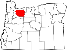 | |
| Hamlets | ||
| CDPs | ||
| Other unincorporated communities |
| |
| Footnotes | ‡This populated place also has portions in an adjacent county or counties | |