Glenhayes, West Virginia
| Glenhayes, West Virginia | |
|---|---|
| Unincorporated community | |
 Glenhayes, West Virginia  Glenhayes, West Virginia | |
| Coordinates: 38°00′51″N 82°31′17″W / 38.01417°N 82.52139°WCoordinates: 38°00′51″N 82°31′17″W / 38.01417°N 82.52139°W | |
| Country | United States |
| State | West Virginia |
| County | Wayne |
| Elevation | 604 ft (184 m) |
| Time zone | Eastern (EST) (UTC-5) |
| • Summer (DST) | EDT (UTC-4) |
| Area code(s) | 304 & 681 |
| GNIS feature ID | 1539466[1] |
Glenhayes is an unincorporated community in Wayne County, West Virginia, United States. Glenhayes is located on the Tug Fork and U.S. Route 52 8.1 miles (13.0 km) southeast of Fort Gay.[2] Glenhayes had a post office, which closed on November 9, 2002.[3]
The community's name is an amalgamation of James K. Glenn and Rutherford B. Hayes, the former a land speculator and the latter the 19th President of the United States.[4]
References
- ↑ U.S. Geological Survey Geographic Names Information System: Glenhayes, West Virginia
- ↑ Wayne County, West Virginia General Highway Map (PDF) (Map). West Virginia Department of Transportation. 2011. p. 2. Retrieved November 10, 2011.
- ↑ "Postmaster Finder - Post Offices by ZIP Code". United States Postal Service. Retrieved November 10, 2011.
- ↑ Kenny, Hamill (1945). West Virginia Place Names: Their Origin and Meaning, Including the Nomenclature of the Streams and Mountains. Piedmont, WV: The Place Name Press. p. 273.
Municipalities and communities of Wayne County, West Virginia, United States | ||
|---|---|---|
| Cities | 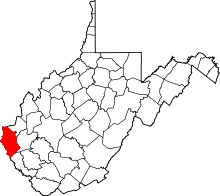 | |
| Towns | ||
| CDPs | ||
| Unincorporated communities |
| |
| Footnotes | ‡This populated place also has portions in an adjacent county or counties | |
This article is issued from Wikipedia - version of the 7/28/2016. The text is available under the Creative Commons Attribution/Share Alike but additional terms may apply for the media files.