Gmina Białe Błota
| Gmina Białe Błota Białe Błota Commune | ||
|---|---|---|
| Gmina | ||
| ||
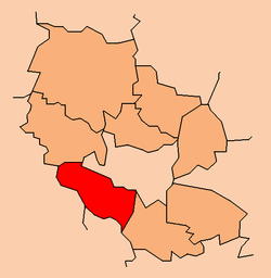 Location within the county | ||
| Coordinates (Białe Błota): 53°5′56″N 17°54′58″E / 53.09889°N 17.91611°ECoordinates: 53°5′56″N 17°54′58″E / 53.09889°N 17.91611°E | ||
| Country |
| |
| Voivodeship | Kuyavian-Pomeranian | |
| County | Bydgoszcz County | |
| Seat | Białe Błota | |
| Area | ||
| • Total | 122.1 km2 (47.1 sq mi) | |
| Population (2006) | ||
| • Total | 14,003 | |
| • Density | 110/km2 (300/sq mi) | |
| Website | http://www.bialeblota.pl/ | |
Gmina Białe Błota is a rural gmina (administrative district) in Bydgoszcz County, Kuyavian-Pomeranian Voivodeship, in north-central Poland. Its seat is the village of Białe Błota, which lies approximately 6 kilometres (4 mi) west of Bydgoszcz.
The gmina covers an area of 122.1 square kilometres (47.1 sq mi), and as of 2006 its total population is 14,003.
Villages
Gmina Białe Błota contains the villages and settlements of Białe Błota, Ciele, Dębinek, Drzewce, Kruszyn Krajeński, Lipniki, Lisi Ogon, Łochowice, Łochowo, Murowaniec, Prądki, Przyłęki, Trzciniec and Zielonka.
Neighbouring gminas
Gmina Białe Błota is bordered by the town of Bydgoszcz and by the gminas of Łabiszyn, Nakło nad Notecią, Nowa Wieś Wielka, Sicienko and Szubin.
References
| Seat |  | |
|---|---|---|
| Other villages | ||
| Urban-rural gminas |  | |
|---|---|---|
| Rural gminas | ||
| Seat |
| |
This article is issued from Wikipedia - version of the 8/21/2013. The text is available under the Creative Commons Attribution/Share Alike but additional terms may apply for the media files.