Gmina Miłkowice
| Gmina Miłkowice Miłkowice Commune | ||
|---|---|---|
| Gmina | ||
| ||
 | ||
| Coordinates (Miłkowice): 51°15′27″N 16°3′24″E / 51.25750°N 16.05667°ECoordinates: 51°15′27″N 16°3′24″E / 51.25750°N 16.05667°E | ||
| Country |
| |
| Voivodeship | Lower Silesian | |
| County | Legnica County | |
| Seat | Miłkowice | |
| Sołectwos | Bobrów, Głuchowice, Gniewomirowice, Goślinów, Grzymalin, Jakuszów, Jezierzany, Kochlice, Lipce, Miłkowice, Pątnówek, Rzeszotary-Dobrzejów, Siedliska, Studnica, Ulesie | |
| Area | ||
| • Total | 86.37 km2 (33.35 sq mi) | |
| Population (2006) | ||
| • Total | 6,101 | |
| • Density | 71/km2 (180/sq mi) | |
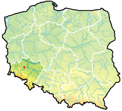
Gmina Miłkowice is a rural gmina (administrative district) in Legnica County, Lower Silesian Voivodeship, in south-western Poland. Its seat is the village of Miłkowice, which lies approximately 9 kilometres (6 mi) north-west of Legnica, and 71 kilometres (44 mi) west of the regional capital Wrocław.
The gmina covers an area of 86.37 square kilometres (33.3 sq mi), and as of 2006 its total population is 6,101.
Neighbouring gminas
Gmina Miłkowice is bordered by the town of Legnica and the gminas of Chojnów, Krotoszyce, Kunice, Lubin and Złotoryja.
Villages
The gmina contains the villages of Bobrów, Dobrzejów, Głuchowice, Gniewomirowice, Goślinów, Grzymalin, Jakuszów, Jezierzany, Kochlice, Lipce, Miłkowice, Pątnówek, Rzeszotary, Siedliska, Studnica and Ulesie.
Sources
Seat (not part of the county): Legnica | ||
| Urban gmina |  | |
| Urban-rural gmina | ||
| Rural gminas | ||
This article is issued from Wikipedia - version of the 10/19/2016. The text is available under the Creative Commons Attribution/Share Alike but additional terms may apply for the media files.