Gmina Perzów
| Gmina Perzów Perzów Commune | |||
|---|---|---|---|
| Gmina | |||
| |||
 | |||
| Coordinates (Perzów): 51°17′N 17°49′E / 51.283°N 17.817°ECoordinates: 51°17′N 17°49′E / 51.283°N 17.817°E | |||
| Country |
| ||
| Voivodeship | Greater Poland | ||
| County | Kępno | ||
| Seat | Perzów | ||
| Area | |||
| • Total | 75.46 km2 (29.14 sq mi) | ||
| Population (2006) | |||
| • Total | 3,925 | ||
| • Density | 52/km2 (130/sq mi) | ||
| Website | http://www.perzow.republika.pl | ||

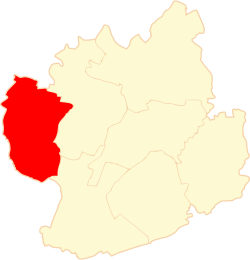
Gmina Perzów is a rural gmina (administrative district) in Kępno County, Greater Poland Voivodeship, in west-central Poland. Its seat is the village of Perzów, which lies approximately 12 kilometres (7 mi) west of Kępno and 139 km (86 mi) south-east of the regional capital Poznań.
The gmina covers an area of 75.46 square kilometres (29.1 sq mi), and as of 2006 its total population is 3,925.
Villages
Gmina Perzów contains the villages and settlements of Brzezie, Domasłów, Koza Wielka, Miechów, Perzów, Słupia pod Bralinem, Trębaczów, Turkowy and Zbyczyna.
Neighbouring gminas
Gmina Perzów is bordered by the gminas of Bralin, Dziadowa Kłoda, Kobyla Góra, Namysłów, Rychtal and Syców.
References
| Seat | ||
|---|---|---|
| Other villages | ||
| Seat |  | |
|---|---|---|
| Urban-rural gmina | ||
| Rural gminas | ||
This article is issued from Wikipedia - version of the 8/20/2013. The text is available under the Creative Commons Attribution/Share Alike but additional terms may apply for the media files.