Gmina Władysławowo
| Gmina Władysławowo Władysławowo Commune | |||
|---|---|---|---|
| Gmina | |||
| |||
 | |||
| Coordinates (Władysławowo): 54°47′35″N 18°24′51″E / 54.79306°N 18.41417°ECoordinates: 54°47′35″N 18°24′51″E / 54.79306°N 18.41417°E | |||
| Country |
| ||
| Voivodeship | Pomeranian | ||
| County | Puck | ||
| Seat | Władysławowo | ||
| Area | |||
| • Total | 39.22 km2 (15.14 sq mi) | ||
| Population (2013) | |||
| • Total | 15,400 | ||
| • Density | 390/km2 (1,000/sq mi) | ||
| Website | http://wladyslawowo.pl/ | ||

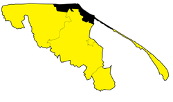
Gmina Władysławowo is an urban-rural gmina (administrative district) in Puck County, Pomeranian Voivodeship, in northern Poland. Its seat is the town of Władysławowo.
The gmina covers an area of 39.22 square kilometres (15.1 sq mi), and as of 2013 its total population was around 15,400.
In years 1973-2014 gmina constituted an urban gmina. This changed on January 1, 2015, when it became an urban-rural gmina.[1]
Villages
Apart from the town of Władysławowo, Gmina Władysławowo contains seven villages: Chałupy, Chłapowo, Jastrzębia Góra, Karwia, Ostrowo, Rozewie and Tupadły.
References
| Seat | ||
|---|---|---|
| Other villages | ||
| Urban gminas |  | |
|---|---|---|
| Urban-rural gminas | ||
| Rural gminas | ||
This article is issued from Wikipedia - version of the 8/5/2016. The text is available under the Creative Commons Attribution/Share Alike but additional terms may apply for the media files.