Goddard, Kansas
| Goddard, Kansas | |
|---|---|
| City | |
 Location within Sedgwick County and Kansas | |
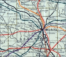
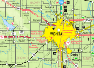 KDOT map of Sedgwick County (legend) | |
| Coordinates: 37°39′35″N 97°34′27″W / 37.65972°N 97.57417°WCoordinates: 37°39′35″N 97°34′27″W / 37.65972°N 97.57417°W | |
| Country | United States |
| State | Kansas |
| County | Sedgwick |
| Founded | 1883 |
| Incorporated | 1910 |
| Government | |
| • Mayor | Marcey Gregory |
| Area[1] | |
| • Total | 4.49 sq mi (11.63 km2) |
| • Land | 4.43 sq mi (11.47 km2) |
| • Water | 0.06 sq mi (0.16 km2) |
| Elevation | 1,463 ft (446 m) |
| Population (2010) | |
| • Total | 4,344 |
| • Estimate (2015)[2] | 4,719 |
| • Density | 970/sq mi (370/km2) |
| Time zone | Central (CST) (UTC-6) |
| • Summer (DST) | CDT (UTC-5) |
| ZIP code | 67052 |
| Area code | 316 |
| FIPS code | 20-26725 [3] |
| GNIS feature ID | 0474001 [4] |
| Website | goddardks.gov |
Goddard is a city in Sedgwick County, Kansas, United States, and a suburb of Wichita. As of the 2010 census, the city population was 4,344.[3]
History
In 1883, Ezekiel Wilder purchased farmland on the planned railway of the Atchison, Topeka, and Santa Fe Railway south of Blendon, Kansas, approximately 10 miles (16 km) west of Wichita.[5] There, he established the town of Goddard in honor of J. F. Goddard, former third vice-president of the ATSF Railway.[6][7] The railroad reached Goddard in 1884, and a post office was established there the same year. Several buildings were relocated from Blendon, including the town hall and the planned Methodist church. Goddard was officially incorporated in 1910.
In recent decades as Wichita has expanded westward, a growing number of commuters have settled in Goddard, transforming it from a rural agricultural community into a suburb.
Geography
Goddard is located at 37°39′35″N 97°34′27″W / 37.65972°N 97.57417°W (37.659706, -97.574271)[8] at an elevation of 1,463 feet (446 m).[4] Goddard lies on U.S. Route 54 in south-central Kansas immediately west of Wichita.[9]
The community lies approximately 12 miles (19 km) southwest of the Arkansas River and 8 miles (13 km) north-northeast of the Ninnescah River in the Wellington-McPherson Lowlands region of the Great Plains.[9][10]
According to the United States Census Bureau, the city has a total area of 4.49 square miles (11.63 km2), of which, 4.43 square miles (11.47 km2) is land and 0.06 square miles (0.16 km2) is water.[1]
Demographics
| Historical population | |||
|---|---|---|---|
| Census | Pop. | %± | |
| 1890 | 210 | — | |
| 1900 | 225 | 7.1% | |
| 1910 | 225 | 0.0% | |
| 1920 | 255 | 13.3% | |
| 1930 | 255 | 0.0% | |
| 1940 | 248 | −2.7% | |
| 1950 | 274 | 10.5% | |
| 1960 | 533 | 94.5% | |
| 1970 | 955 | 79.2% | |
| 1980 | 1,427 | 49.4% | |
| 1990 | 1,804 | 26.4% | |
| 2000 | 2,037 | 12.9% | |
| 2010 | 4,344 | 113.3% | |
| Est. 2015 | 4,719 | [2] | 8.6% |
| U.S. Decennial Census[11] | |||
Goddard is part of the Wichita, KS Metropolitan Statistical Area.
2010 census
As of the 2010 United States Census, there were 4,344 people, 1,442 households, and 1,124 families residing in the city. The population density was 979.5 people per square mile (378.2/km²). There were 1,542 housing units at an average density of 347.7 per square mile (134.2/km²). The racial makeup of the city was 91.5% White, 1.2% Asian, 0.9% African American, 0.8% American Indian, 2.6% from other races, and 3.1% from two or more races. Hispanics and Latinos of any race were 6.4% of the population.[3]
There were 1,442 households of which 49.5% had children under the age of 18 living with them, 63.5% were married couples living together, 9.8% had a female householder with no husband present, 4.6% had a male householder with no wife present, and 22.1% were non-families. 18.5% of all households were made up of individuals, and 5.4% had someone living alone who was 65 years of age or older. The average household size was 2.98, and the average family size was 3.44.[3]
The median age in the city was 29.5 years. 35.1% of residents were under the age of 18; 6.7% were between the ages of 18 and 24; 33.4% were from 25 to 44; 18.1% were from 45 to 64; and 6.7% were 65 years of age or older. The gender makeup of the city was 48.9% male and 51.1% female.[3]
The median income for a household in the city was $65,139, and the median income for a family was $66,533. Males had a median income of $51,058 versus $33,542 for females. The per capita income for the city was $22,095. About 3.7% of families and 5.0% of the population were below the poverty line, including 5.1% of those under age 18 and 7.1% of those age 65 or over.[3]
2000 census
As of the census of 2000, there were 2,037 people, 666 households, and 534 families residing in the city. The population density was 837.5 people per square mile (323.7/km²). There were 698 housing units at an average density of 287.0 per square mile (110.9/km²). The racial makeup of the city was 95.14% White, 0.29% African American, 0.98% Native American, 0.74% Asian, 0.05% Pacific Islander, 0.59% from other races, and 2.21% from two or more races. Hispanic or Latino of any race were 1.91% of the population.
There were 666 households out of which 49.5% had children under the age of 18 living with them, 64.4% were married couples living together, 10.4% had a female householder with no husband present, and 19.8% were non-families. 17.1% of all households were made up of individuals and 5.1% had someone living alone who was 65 years of age or older. The average household size was 2.94 and the average family size was 3.34.
In the city the population was spread out with 33.4% under the age of 18, 7.7% from 18 to 24, 29.8% from 25 to 44, 18.9% from 45 to 64, and 10.2% who were 65 years of age or older. The median age was 33 years. For every 100 females there were 93.3 males. For every 100 females age 18 and over, there were 88.2 males.
The median income for a household in the city was $50,352, and the median income for a family was $53,690. Males had a median income of $39,881 versus $23,807 for females. The per capita income for the city was $18,957. About 2.6% of families and 3.6% of the population were below the poverty line.[3]
Economy
As of 2012, 75.9% of the population over the age of 16 was in the labor force. 0.5% was in the armed forces, and 75.3% was in the civilian labor force with 70.4% being employed and 5.0% unemployed. The composition, by occupation, of the employed civilian labor force was: 40.3% in management, business, science, and arts; 22.5% in sales and office occupations; 17.1% in service occupations; 11.6% in production, transportation, and material moving; and 8.4% in natural resources, construction, and maintenance. The three industries employing the largest percentages of the working civilian labor force were: manufacturing (22.7%); educational services, health care, and social assistance (20.9%); and retail trade (12.4%).[3]
The cost of living in Goddard is relatively low; compared to a U.S. average of 100, the cost of living index for the city is 84.5.[12] As of 2012, the median home value in the city was $140,400, the median selected monthly owner cost was $1,341 for housing units with a mortgage and $373 for those without, and the median gross rent was $1,013.[3]
Government
Goddard is a city of the second class with a mayor-council form of government.[13] The city council consists of the mayor and five council members.[14] The council establishes policies and legislation. The city administrator advises the council, directs the city government, and prepares and submits the annual city budget.[15] The council meets on the first and third Mondays of each month.[13]
Goddard lies within Kansas's 4th U.S. Congressional District. For the purposes of representation in the Kansas Legislature, the city is located in the 26th and 27th districts of the Kansas Senate and the 93rd and 101st districts of the Kansas House of Representatives.[13]
Education
Primary and secondary education
Goddard Public Schools (USD 265) operates eleven schools in and around the city:[16]
|
|
The Roman Catholic Diocese of Wichita operates one Catholic school in Goddard: Holy Spirit Catholic School (Pre-K-8).[17]
Libraries
The Goddard Public Library, located downtown, has a collection of over 16,000 volumes and offers technology services and literacy programs to the public.[18][19]
Infrastructure
Transportation
U.S. Route 54 and U.S. Route 400 run concurrently east-west through Goddard.[9]
Utilities
The city government's Public Works Department is responsible for both water provision and waste water management.[20] Westar Energy provides electric power.[21] Most residents use natural gas for heating fuel; service is provided by Kansas Gas Service.[12][21]
Media
Goddard is in both the Wichita radio and television markets.[22][23]
Parks and recreation
The city government maintains two parks in the community as well as a municipal swimming pool.[24][25]
Culture
Events
Goddard's Chamber of Commerce, Lions Club, Activities Committee, and city government organize many community events during the year including an Easter Egg Hunt, Garage Sale Days, Independence Day Firework Display, National Night Out, Fall Festival, Goddard Community Gatherings, Community Thanksgiving Feast, City Christmas Tree Lighting, and Breakfast with Santa.[26]
Points of interest
Tanganyika Wildlife Park, a privately owned zoo specializing in the breeding of endangered species, is located in Goddard.[27] The Park is open yearly from April to October.[28]
Notable people
Notable individuals who were born in and/or have lived in Goddard include:
- Derek Norris (1989- ), baseball catcher[29]
- Ed Siever (1875-1920), baseball pitcher[30]
- Todd Tiahrt (1951- ), U.S. Representative from Kansas[31]
- Logan Watkins (1989- ), baseball 2nd baseman[32]
See also
References
- 1 2 "US Gazetteer files 2010". United States Census Bureau. Retrieved 2012-07-06.
- 1 2 "Annual Estimates of the Resident Population for Incorporated Places: April 1, 2010 to July 1, 2015". Retrieved July 2, 2016.
- 1 2 3 4 5 6 7 8 9 "American FactFinder". United States Census Bureau. Retrieved 2012-07-12.
- 1 2 "US Board on Geographic Names". United States Geological Survey. 2007-10-25. Retrieved 2008-01-31.
- ↑ "History". City of Goddard, Kansas. Retrieved 2014-06-27.
- ↑ Gannett, Henry (1905). The Origin of Certain Place Names in the United States. Govt. Print. Off. p. 139.
- ↑ The Atchison, Topeka, and Santa Fe Railway and Auxiliary Companies - Annual Meetings, and Directors and Officers; January 1, 1902
- ↑ "US Gazetteer files: 2010, 2000, and 1990". United States Census Bureau. 2011-02-12. Retrieved 2011-04-23.
- 1 2 3 "2003-2004 Official Transportation Map" (PDF). Kansas Department of Transportation. 2003. Retrieved 2011-03-28.
- ↑ "General Highway Map - Sedgwick County, Kansas" (PDF). Kansas Department of Transportation. 2009-06-01. Retrieved 2011-03-28.
- ↑ United States Census Bureau. "Census of Population and Housing". Retrieved February 14, 2014.
- 1 2 "Goddard, Kansas". City-Data.com. Retrieved 2014-10-24.
- 1 2 3 "Goddard". Directory of Kansas Public Officials. The League of Kansas Municipalities. Retrieved 2014-10-24.
- ↑ "City of Goddard, Kansas Government". City of Goddard, Kansas. Retrieved 2011-03-28.
- ↑ "City Administrator". City of Goddard, Kansas. Retrieved 2011-03-28.
- ↑ "USD 265 Goddard Public Schools". Goddard Public Schools. Retrieved 2010-06-06.
- ↑ "2010-11 School Directory". Roman Catholic Diocese of Wichita. Retrieved 2011-03-28.
- ↑ "Goddard Public Library - Goddard, KS". libraries.org - A directory of libraries throughout the world. Retrieved 2014-10-24.
- ↑ "Programs". Goddard Public Library. Retrieved 2014-10-24.
- ↑ "Public Works". City of Goddard, Kansas. Retrieved 2014-10-24.
- 1 2 "Telephone & Utilities". Wichita Metro Chamber of Commerce. Retrieved 2014-10-24.
- ↑ "2011 Arbitron Radio Metro Map" (PDF). Arbitron. Retrieved 2014-10-24.
- ↑ "Kansas [Map]". EchoStar Knowledge Base. Retrieved 2014-10-24.
- ↑ "Goddard Living". Goddard Chamber of Commerce. Retrieved 2014-10-24.
- ↑ "Goddard City Pool". City of Goddard, Kansas. Retrieved 2014-10-24.
- ↑ "Events". The City of Goddard. Retrieved 2013-11-22.
- ↑ "About Tanganyika Wildlife Park". Tanganyika Wildlife Park. Retrieved 2011-02-18.
- ↑ "General Info & Prices". Tanganyika Wildlife Park. Retrieved 2011-02-18.
- ↑ "Derek Norris". Baseball-Reference.com. Retrieved 2016-04-06.
- ↑ "Ed Siever". Baseball-Reference.com. Retrieved 2016-04-06.
- ↑ Lowry, Bryan. "Former U.S. Rep. Tiahrt takes job with D.C. lobbying firm". The Wichita Eagle. Retrieved 2016-04-06.
- ↑ "Logan Watkins". Baseball-Reference.com. Retrieved 2016-04-06.
!["Kansas [Map]"](http://dishuser.org/TVMarkets/Maps/kansas.gif)
External links
| Wikimedia Commons has media related to Goddard, Kansas. |
- City
- Schools
- USD 265, local school district
- USD 265 School District Boundary Map, KDOT
- Maps
- Goddard City Map, KDOT
Municipalities and communities of Sedgwick County, Kansas, United States | ||
|---|---|---|
| Cities | 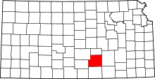 | |
| CDPs | ||
| Unincorporated communities | ||
| Townships | ||
| Footnotes | ‡This populated place also has portions in an adjacent county or counties | |