Going am Wilden Kaiser
| Going am Wilden Kaiser | ||
|---|---|---|
 | ||
| ||
 Going am Wilden Kaiser Location within Austria | ||
| Coordinates: 47°30′52″N 12°19′41″E / 47.51444°N 12.32806°ECoordinates: 47°30′52″N 12°19′41″E / 47.51444°N 12.32806°E | ||
| Country | Austria | |
| State | Tyrol | |
| District | Kitzbühel | |
| Government | ||
| • Mayor | Josef Pirchl | |
| Area | ||
| • Total | 20.6 km2 (8.0 sq mi) | |
| Elevation | 773 m (2,536 ft) | |
| Population (1 January 2016)[1] | ||
| • Total | 1,870 | |
| • Density | 91/km2 (240/sq mi) | |
| Time zone | CET (UTC+1) | |
| • Summer (DST) | CEST (UTC+2) | |
| Postal code | 6353 | |
| Area code | 05358 | |
| Vehicle registration | KB | |
| Website | www.going.tirol.gv.at | |

Going am Wilden Kaiser is a municipality in the district of Kitzbühel in the Austrian region of Sölllandl. It is located 8.5 km northwest of Kitzbühel and 5 km west of Sankt Johann in Tirol. The village has 1851 inhabitants, 5 sub-districts and was mentioned as Gouwingen for the first time in 1160. Its main source of income is tourism. It is connected to the large Ski Welt skiing area by the Asitzbahn chairlift, which takes skiers rapidly from Going in the valley up to the large expanse of ski terrain on the mountainsides.
Geography
Going lies west of St. Johann in Tirol between the Kitzbühel Alps in the south and the Wild Kaiser in the north in the Sölllandl. Other hamlets in the municipality are: Schwendt, Aschau, Prama, Sonnseite and Schattseite.
Neighbouring municipalities: Ellmau, Oberndorf in Tirol, Reith bei Kitzbühel, St. Johann in Tirol, Kirchdorf in Tirol
History
In 1160 the village was first mentioned in a deed at Baumbach Abbey as Gouwingen. In 2010 the 850th anniversary of this record was celebrated. The name is derived from a Bajuvarian nobleman, Guowo or Gauwo. This suggests it was founded by the Bavarii. The village church is one of the most impressive rococo churches in Tyrol. It is consecrated to the Holy Cross and the martyr, Laurentius. Its architect was Andrä Hueber and the frescoist was Matthias Kirchner, both from Kitzbühel. The altars and holy figures were carved by Going sculptor, Thomas Blieml. There is an interesting madonna in the altar niche of the left-hand altar, carved around 1480.
Copper and silver were mined at Rehrobichl between Going and Oberndorf in the first quarter of the 16th century. The miners (Bergknappen) lived in the hamlet of Prama. Prama is Celtic and means "the place where the blackberries (Brombeeren) grow." This is a clue that it was a Celtic settlement. The Celts mined copper and silver in this region in around 800 B. C. The mine was closed around 1773. In its heyday, about 12,000 kg of copper and 7,000 kg of silver were won annually. The smelter was in the hamlet of Bärenstätten von St. Johann. The deepest, vertical mineshaft was about 880 metres deep.
Population
| Historical population | ||
|---|---|---|
| Year | Pop. | ±% |
| 1869 | 739 | — |
| 1880 | 820 | +11.0% |
| 1890 | 751 | −8.4% |
| 1900 | 738 | −1.7% |
| 1910 | 664 | −10.0% |
| 1923 | 752 | +13.3% |
| 1934 | 825 | +9.7% |
| 1939 | 867 | +5.1% |
| 1951 | 918 | +5.9% |
| 1961 | 966 | +5.2% |
| 1971 | 1,152 | +19.3% |
| 1981 | 1,180 | +2.4% |
| 1991 | 1,449 | +22.8% |
| 2001 | 1,730 | +19.4% |
| 2011 | 1,851 | +7.0% |
Economy
Today, in addition to many handicraft, industrial and trading businesses, Going is dominated by agriculture and the winter and summer tourist industries.
- Summer activities and facilities: hiking trails, climbing, mountaineering, natural bathing lake with the longest open-air water slide in Tyrol, beach volleyball, tennis courts and halls, squash hall, 27 hole golf course, riding hall and bridleways, cycle paths, asphaltstockbahnen, Zimmergewehr firing range, open air climbing wall, children's and family programmes, moorland experience world, etc.
- Winter activities and facilities: Skiwelt Wilder Kaiser-Brixental, Going-Ellmau ski area, cross-country skiing trails, toboggan runs, winter himing trails, tennis hall, squash hall, ice rink, Zimmergewehr firing range, asphaltstockhalle, indoor climbing wall.
Personalities
- Johann von Sieberer (1830-1914), insurance general inspector and philanthropist
Gallery
 Going am Wilden Kaiser
 Municipal office
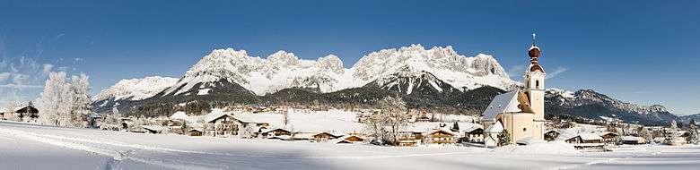
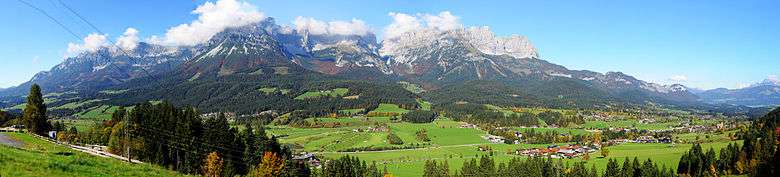
Panorama
External links
| Wikimedia Commons has media related to Going am Wilden Kaiser. |
- Website of the municipality at Landesserver Tirol
- Website of the Going Information Office, Tourismusverband Wilder Kaiser (www.going.at)
- Going Gigapixel Panorama (11.000 Megapixel)
- Village chronicle
- www.geschichte-tirol.com: Going am Wilden Kaiser
References
- ↑ Statistik Austria - Bevölkerung zu Jahresbeginn 2002-2016 nach Gemeinden (Gebietsstand 2016-01-01), 2016-01-01.