Gojō, Nara
For the soap company, see GOJO.
| Gojō 五條市 | ||
|---|---|---|
| City | ||
|
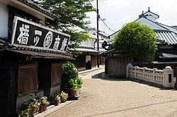
Gojo Shinmachi designated as Important Preservation Districts for Groups of Historic Buildings in Japan | ||
| ||
 Location of Gojō in Nara Prefecture | ||
 Gojō Location in Japan | ||
| Coordinates: 34°20′55″N 135°41′47″E / 34.34861°N 135.69639°ECoordinates: 34°20′55″N 135°41′47″E / 34.34861°N 135.69639°E | ||
| Country | Japan | |
| Region | Kansai | |
| Prefecture | Nara Prefecture | |
| Government | ||
| • Mayor | Yoshinori Ota (since May 2011) | |
| Area | ||
| • Total | 291.98 km2 (112.73 sq mi) | |
| Population (May 31, 2011) | ||
| • Total | 33,283 | |
| • Density | 121.17/km2 (313.8/sq mi) | |
| Symbols | ||
| • Tree | Camphor Laurel | |
| • Flower | Chinese bellflower | |
| Time zone | Japan Standard Time (UTC+9) | |
| City hall address |
1-1-1 Honmachi, Gojō-shi, Nara-ken 637-8501 | |
| Website |
www | |

Gojō (五條市 Gojō-shi) is a city located in Nara Prefecture, Japan. The city was founded on October 15, 1957.
As of September 30, 2014, the city has an estimated population of 33,283, with 13,742 households.[1] It has a population density of 121.17 persons per km². The total area is 291.98 km².
On September 25, 2005, the villages of Nishiyoshino and Ōtō (both from Yoshino District) were merged into Gojō.
Geography
Located in western Nara Prefecture, the Yoshino River flows through the city. It is surrounded mostly by mountains, although the city hall is located in a flat basin. Situated north of the city hall is Mount Kongō, at 1125 m. Persimmon is a major fruit crop in Gojō.[2]
Neighboring municipalities
Education
- Primary Schools
- Gojō Elementary School
- Sakaaibe Elementary School
- Nishiyoshino Elementary School
- Makino Elementary School
- Nohara Elementary School
- Ootō Elementary School
- Uchi Elementary School
- Kitauchi Elementary School
- Ada Elementary School
- Junior High Schools
- Gojō Junior High School
- Gojōnishi Junior High School
- Gojōhigashi Junior High School
- Nishiyoshino Junior High School
- Ootō Junior High School
- Nohara Junior High School
- High Schools
- Gojō High School
- Chiben Gakuen High School
Transportation
Rail
Roads
- Expressways
- Keinawa Expressway
 Japan National Route 24
 Japan National Route 168
 Japan National Route 309
 Japan National Route 310
 Japan National Route 370
References
- ↑ "平成26年9月30日現在" (PDF). Gojō City. September 30, 2014. Retrieved October 22, 2014.
- ↑ 2005.Kangaeru Shakaika Chizu.Tokyo:Yotsuya-Ōtsuka Publishing, p.36
External links
- Gojō City official website (Japanese)
| Wikimedia Commons has media related to Gojo, Nara. |
| Core city | ||
|---|---|---|
| Cities | ||
| Ikoma District | ||
| Kitakatsuragi District | ||
| Shiki District | ||
| Takaichi District | ||
| Uda District | ||
| Yamabe District | ||
| Yoshino District | ||
This article is issued from Wikipedia - version of the 11/5/2015. The text is available under the Creative Commons Attribution/Share Alike but additional terms may apply for the media files.