Golden Valley, Nevada
| Golden Valley, Nevada | |
|---|---|
| Census-designated place | |
 Location of Golden Valley, Nevada | |
| Coordinates: 39°36′55″N 119°49′35″W / 39.61528°N 119.82639°WCoordinates: 39°36′55″N 119°49′35″W / 39.61528°N 119.82639°W | |
| Country | United States |
| State | Nevada |
| Area | |
| • Total | 3.6 sq mi (9.4 km2) |
| • Land | 3.6 sq mi (9.4 km2) |
| • Water | 0.0 sq mi (0.0 km2) |
| Elevation | 5,092 ft (1,552 m) |
| Population (2010) | |
| • Total | 1,556 |
| • Density | 430/sq mi (170/km2) |
| Time zone | Pacific (PST) (UTC-8) |
| • Summer (DST) | PDT (UTC-7) |
| ZIP code | 89506 |
| FIPS code | 32-28860 |
Golden Valley is a census-designated place (CDP) in Washoe County, Nevada, United States. The population was 1,556 at the 2010 census.[1] It is a northern suburb of the city of Reno and is part of the Reno–Sparks Metropolitan Statistical Area. Prior to 2010 it was listed by the U.S. Census Bureau as part of the Lemmon Valley–Golden Valley CDP.
Geography
Golden Valley is located at 39°36′55″N 119°49′35″W / 39.61528°N 119.82639°W (39.6155, -119.8266), 7 miles (11 km) north of downtown Reno. Lemmon Valley is adjacent to the north.
According to the United States Census Bureau, the CDP has a total area of 3.6 square miles (9.4 km2), all land.[1]
References
- 1 2 "Geographic Identifiers: 2010 Demographic Profile Data (G001): Golden Valley CDP, Nevada". U.S. Census Bureau, American Factfinder. Retrieved January 16, 2013.
Municipalities and communities of Washoe County, Nevada, United States | ||
|---|---|---|
| Cities | 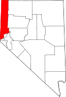 | |
| CDPs | ||
| Unincorporated communities | ||
| Indian reservation | ||
| Indian colony | ||
| Ghost towns | ||
This article is issued from Wikipedia - version of the 11/18/2015. The text is available under the Creative Commons Attribution/Share Alike but additional terms may apply for the media files.