Gondia
| Gondia गोंदिया Gondiya | |
|---|---|
| City | |
| Nickname(s): Rice City | |
 Gondia Location in Maharashtra, India | |
| Coordinates: 21°27′35″N 80°11′42″E / 21.4598°N 80.195°ECoordinates: 21°27′35″N 80°11′42″E / 21.4598°N 80.195°E | |
| Country |
|
| State | Maharashtra |
| District | Gondia |
| Government | |
| • Type | Local |
| • Body | Municipal Council |
| Area | |
| • Total | 30 km2 (10 sq mi) |
| Elevationd | 300 m (1,000 ft) |
| Population (2011)[1] (urban agglomeration ≈ 180,000) | |
| • Total | 132,821 |
| • Rank | 256 |
| • Density | 4,400/km2 (11,000/sq mi) |
| Language | |
| • Official | Marathi |
| Time zone | IST (UTC+5:30) |
| PIN | 441601,441614 |
| Telephone code | +91-07182 |
| Vehicle registration | MH-35 |
| Sex ratio | 991 per 1000 male. ♂/♀ |
| Website |
gondia |
Gondia also spelt as Gondiya is a major city in the state of Maharashtra in Central India, and is the administrative headquarters of the Gondia District. Gondia is also known as Rice City due to the abundance of rice mills in the area. Gondia is very close to the state of Madhya Pradesh, and is considered the gateway to Maharashtra from Central and Eastern India.There are large number of rice mills and some small scale tobacco industries.
In ancient time, this region was ruled over by Gond kings. The main business at that time was to collect lak (sealing wax) from Palas tree and gum from Babul tree, gum is called as gond in Hindi, therefore the name Gondia is tagged to the place. Railway Station is big.
Climate
| Climate data for Gondia | |||||||||||||
|---|---|---|---|---|---|---|---|---|---|---|---|---|---|
| Month | Jan | Feb | Mar | Apr | May | Jun | Jul | Aug | Sep | Oct | Nov | Dec | Year |
| Average high °C (°F) | 27.6 (81.7) |
31.1 (88) |
35.2 (95.4) |
39.0 (102.2) |
42.1 (107.8) |
38.1 (100.6) |
30.5 (86.9) |
29.9 (85.8) |
30.8 (87.4) |
31.0 (87.8) |
29.3 (84.7) |
27.9 (82.2) |
32.71 (90.88) |
| Average low °C (°F) | 13.3 (55.9) |
15.4 (59.7) |
19.6 (67.3) |
24.6 (76.3) |
28.9 (84) |
27.4 (81.3) |
24.3 (75.7) |
24.1 (75.4) |
23.9 (75) |
21.2 (70.2) |
15.2 (59.4) |
12.9 (55.2) |
20.9 (69.62) |
| Average precipitation mm (inches) | 18.0 (0.709) |
30.7 (1.209) |
16.0 (0.63) |
16.0 (0.63) |
13.7 (0.539) |
219.2 (8.63) |
503.9 (19.839) |
443.5 (17.461) |
222.3 (8.752) |
66.5 (2.618) |
22.9 (0.902) |
5.8 (0.228) |
1,578.5 (62.147) |
| Source: Government of Maharashtra | |||||||||||||
Transport
Rail
Gondia railway station is an important junction and has heavy passenger and goods traffic. It is an A-Grade station on Howrah-Mumbai route. The station has seven platforms. All platforms have adequately been provided with amenities such as potable water, tea stalls, benches and waiting sheds. There is a fruit stall and a book stall too. The station is also equipped with A/C waiting rooms for passengers travelling by upper accommodation classes and a waiting hall for passengers travelling by lower accommodation classes.
Gondia is situated on the broad gauge Howrah-Nagpur-Mumbai line. The Gondia–Jabalpur Junction (Madhya Pradesh) section of South East Central Railway runs north–south, along the valley of the Wainganga River. The line was formerly narrow gauge (2 ft 6 in (762 mm)) along its entire length, but the section between Gondia and Balaghat was converted to broad gauge in 2005–2006,[2] connecting Balaghat to India's national broad gauge network for the first time. Work is underway to convert the Balaghat–Jabalpur section to broad gauge as well.
Gondia Railway Station History
The great famine of 1878 provided an opportunity for the construction of 150 km long meter gauge link called the Nagpur Chhattisgarh Railway in 1882 connecting Nagpur with Rajnandgaon. Gondia Railway station came into existence in December 1888 when this line started working. The scope of BNR was greatly enhanced by the historic contract dated 23 January 1902. This contract provided railway line from Gondia to Jabalpur with Branches from Nainpur to Mandla, Nainpur to Seoni and Chhindwara. The "10001 Satpura Express", a narrow gauge train, was started in 1901 by the British Government and completed 100 years of service in 2001. This train used to hold the unique distinction of operating first class service on narrow gauge track; it is the world's fastest narrow gauge train. The first portion of Gondia-Nainpur section of 73 miles was opened on 13 April 1903. It was further extended till Jabalpur in 1905. Initially Gondia comes under the Nagpur Chhattisgarh railway and nice book can be found on Indian railways site.[3]
Some of the Mile stone in history of Gondia Railway station includes:
- December 1888 - Gondia Railway Station opened for public
- 13 April 1903 - The first portion of Gondia-Nainpur (73 miles) was opened.
- 1905 - Nainpur-Gondia line was extended up to Jabalpur.
- 9th Nov 1908 - Gondia-Nagbhir-Nagpur line was opened for traffic. Mr Manson was Agent of BNR at that time
- January 1999 - Gauge Converted Gondia Ballarshah Line opened
- September 2005 - Gauge converted Gondia Balaghat section opened
Air
Gondia Airport is situated near Kamtha Village, 12 km from Gondia City. This Airstrip was built by the British during World War Two in 1940.[4] Initially run by the Public Works Department, it was taken over by the state-owned MIDC from August 1998[5] to December 2005, after which it has been operated by the Airports Authority of India (AAI). The AAI has extended the runway at Gondia airport to 7,500 feet to handle the operations of aircraft like Airbus A-320 and Boeing 737.[6]
References
- ↑ "Gondiya (Gondia) District Population Census 2011, Maharashtra literacy sex ratio and density". Census2011.co.in. Retrieved 2014-08-23.
- ↑ Railway Gazette International Supplement December 2007 p7
- ↑ "The Roaring Journey" (PDF). secr.indianrailways.gov.in.
- ↑ "Airstrips in Maharashtra". Maharashtra Public Works Department. Retrieved 1 April 2012.
- ↑ "MIDC airports". Retrieved 30 January 2012.
- ↑ "Akola, Gondia next aviation hot spots". Times of India. 27 November 2007. Retrieved 30 January 2012.
 |
Balaghat (Madhya Pradesh) | | ||
| Tirora | |
|||
| ||||
| | ||||
| Goregaon, Sadak Arjuni | Amgaon, Salekasa |
Gondia district topics | ||
|---|---|---|
| History | 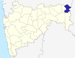 | |
| Geography | ||
| Cities and towns | ||
| Transport | ||
| Culture | ||
| Lok Sabha constituencies | ||
| Vidhan Sabha constituencies | ||