Gorleston South Pier Lighthouse
 Gorleston South Pier Lighthouse and Coastwatch station. | |
 Norfolk | |
| Location |
Gorleston Norfolk England |
|---|---|
| Coordinates | 52°34′20″N 1°44′17″E / 52.572128°N 1.738036°ECoordinates: 52°34′20″N 1°44′17″E / 52.572128°N 1.738036°E |
| Year first constructed | 1852 (first) |
| Year first lit | 1955 (current) |
| Construction | brick and concrete building |
| Tower shape | 2-storey parallelepiped building with two balconies and light on the roof |
| Markings / pattern | white lower part, unpainted brick upper part |
| Height | 8 metres (26 ft) |
| Focal height | 11 metres (36 ft) |
| Light source | mains power |
| Range | 11 nautical miles (20 km; 13 mi) |
| Characteristic | Fl R 3s. |
| Fog signal | 3 blasts every 60s. |
| Admiralty number | A2304 |
| NGA number | 1624 |
| ARLHS number | ENG-221 |
| Managing agent | National Coastwatch Institution [1] |
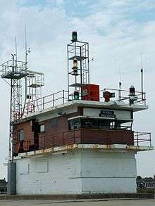
Gorleston South Pier Lighthouse and Coastwatch station is located in the town of Gorleston in the English county of Norfolk.[2] The lighthouse and station is located at the end of the south pier of seaport on the south side of Great Yarmouth.
History
The first lighthouse was established here in 1852 was an octagonal brick tower of similar height to the present lighthouse building. The building today was built in 1955 and was also the harbourmaster's office, later re-located.
Operation
The light of today is mounted on the roof along with communications equipment, harbor control lights, and the fog horn that would gives, when used, three blasts every 60 seconds. The lighthouse is operated by the Great Yarmouth Port Authority. The watchtower is now home to the Gorleston Branch of the National Coastwatch Institution which has over 60 Volunteer members and act as the eyes and ears of HM Coast Guard. They man watches from 0800hrs to 1900hrs in the winter and to 2130hrs in the summer, 7 days a week, 52 weeks of the year.[3]
See also
References
- ↑ Gorleston South Pier Lighthouse The Lighthouse Directory. University of North Carolina at Chapel Hill. Retrieved April 27, 2016
- ↑ Ordnance Survey (2005). OS Explorer Map OL40 - The Broads. ISBN 0-319-23769-9.
- ↑ "NCI Gorleston". National Coastwatch Institution. Retrieved 20 December 2010.
External links
| Wikimedia Commons has media related to Gorleston South Pier Lighthouse. |