Grímsvötn
| Grímsvötn | |
|---|---|
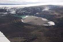
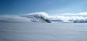 Grímsvötn and the Vatnajökull glacier, Iceland, July 1972 | |
| Highest point | |
| Elevation | 1,725 m (5,659 ft) [1] |
| Listing | List of volcanoes in Iceland |
| Coordinates | 64°25′12″N 17°19′48″W / 64.42000°N 17.33000°WCoordinates: 64°25′12″N 17°19′48″W / 64.42000°N 17.33000°W |
| Geography | |
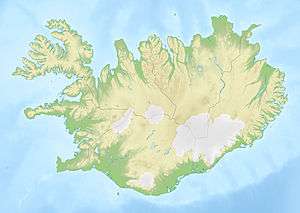 Grímsvötn Austur-Skaftafellssýsla / Vestur-Skaftafellssýsla, Iceland | |
| Geology | |
| Mountain type | Volcanic caldera |
| Last eruption | May 2011 |
Grímsvötn (Icelandic pronunciation: [ˈkrimsvœʰtn̥];[2] vötn = "waters", singular: vatn) is a volcano in South-East Iceland. It is in the highlands of Iceland at the northwestern side of the Vatnajökull ice-cap. The caldera is at 64°25′N 17°20′W / 64.417°N 17.333°W, at an elevation of 1,725 m (5,659 ft). Beneath the caldera is the magma chamber of the Grímsvötn volcano.
Grímsvötn is a basaltic volcano which has the highest eruption frequency of all the volcanoes in Iceland and has a southwest-northeast-trending fissure system. The massive climate-impacting Laki fissure eruption of 1783–1784 was a part of the same fissure system. Grímsvötn was erupting at the same time as Laki during 1783, but continued to erupt until 1785. Because most of the volcano lies underneath Vatnajökull, most of its eruptions have been subglacial and the interaction of magma and meltwater from the ice causes phreatomagmatic explosive activity.
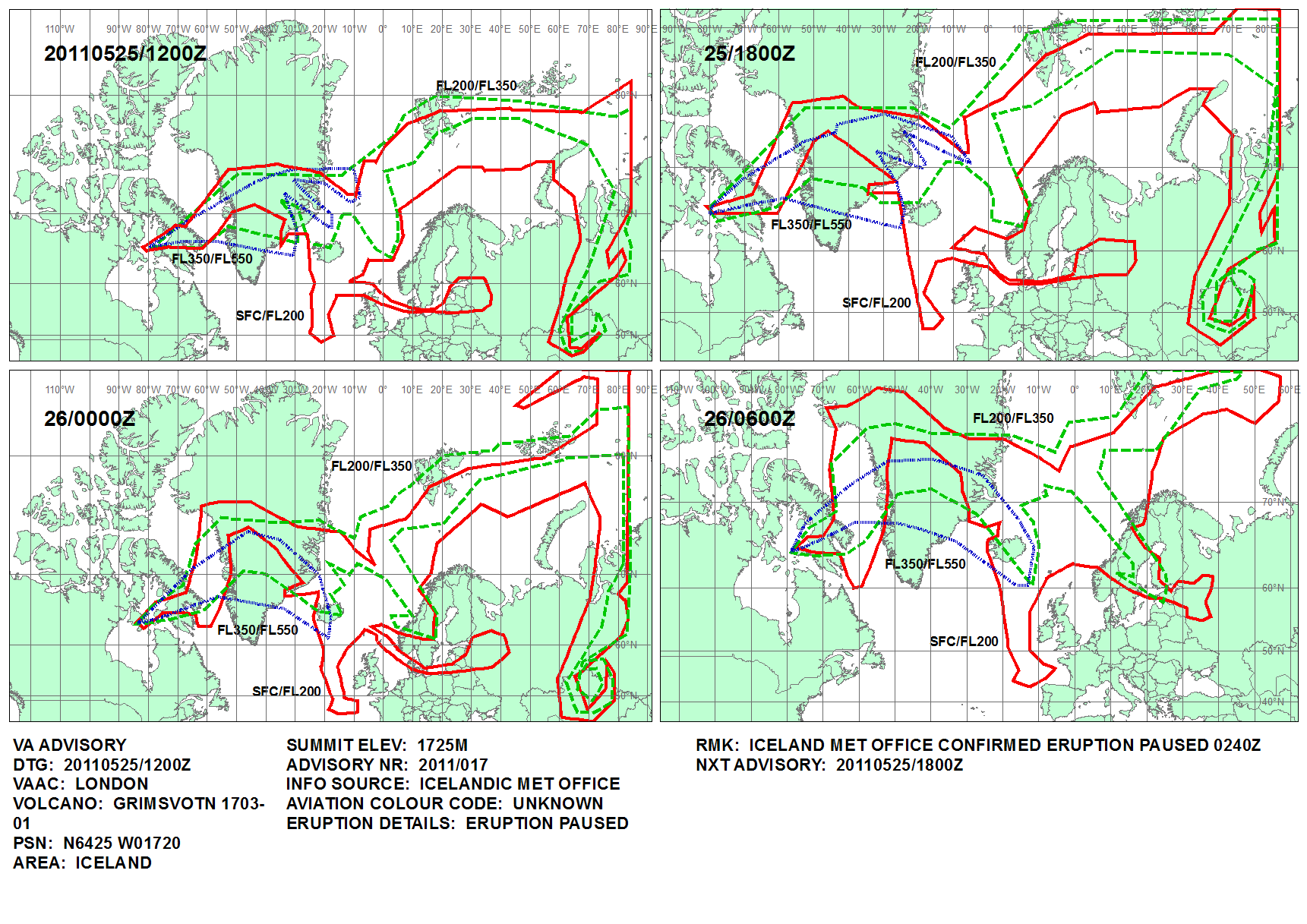
On 21 May 2011 at 19:25 UTC, an eruption began, with 12 km (7 mi) high plumes accompanied by multiple earthquakes,[3][4][5][6] resulting in cancellation of 900 flights[7] in Iceland,[8][9] and in the United Kingdom, Greenland, Germany, Ireland and Norway on 22–25 May. Until 25 May the eruption scale had been larger than that of the 2010 eruption of Eyjafjallajökull. The eruption stopped at 02:40 UTC on 25 May 2011, although there was some explosive activity from the tephra vents affecting only the area around the crater.[10][11][12]
Jökulhlaup
Eruptions in the caldera regularly cause glacial outbursts known as jökulhlaup.[13] Eruptions melt enough ice to fill the Grímsvötn caldera with water, and the pressure may be enough to suddenly lift the icecap, allowing huge quantities of water to escape rapidly. Consequently, the Grímsvötn caldera is monitored very carefully.
When a large eruption occurred in 1996, geologists knew well in advance that a glacial burst was imminent. It did not occur until several weeks after the eruption finished, but monitoring[14] ensured that the Icelandic ring road (Hringvegur) was closed when the burst occurred. A section of road across the Skeiðará sandur was washed away in the ensuing flood, but no one was hurt.
1998 and 2004 eruptions
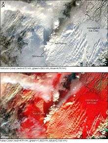
A week-long eruption occurred at Grímsvötn starting on 28 December 1998, but no glacial burst occurred. In November 2004, a week-long eruption occurred. Volcanic ash from the eruption fell as far away as mainland Europe and caused short-term disruption of airline traffic into Iceland, but again no glacial burst followed the eruption.
2011 eruption
Harmonic tremors were recorded twice around Grímsvötn on 2 and 3 October 2010, possibly indicating an impending eruption.[15] At the same time, sudden inflation was measured by GPS in the volcano, indicating magma movement under the mountain. On 1 November 2010 meltwater from the Vatnajökull glacier was flowing into the lake, suggesting that an eruption of the underlying volcano.
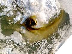

On 21 May 2011 at 19:25 UTC, an eruption began, with 12 km (7 mi) high plumes accompanied by multiple earthquakes.[4][5][6] The ash cloud from the eruption rose to 20 km (12 mi), and is so far 10 times larger than the 2004 eruption, and the strongest in Grímsvötn in the last 100 years.[16]

Disruption to air travel in Iceland[8] commenced on 22 May, followed by Greenland, Scotland,[17] Norway, Svalbard[18] and a small part of Denmark on subsequent days. On 24 May the disruption spread to Northern Ireland and to airports in northern England.[8] The cancellation of 900 out of 90,000 European flights[7] in the period 23–25 May was much less widespread than the 2010 disruption after the Eyjafjallajökull eruption.
Bacteria in the subglacial lakes
In 2004, a community of bacteria was detected in water of the Grímsvötn lake under the glacier, the first time that bacteria have been found in a subglacial lake. The lakes never freeze because of the volcanic heat. The bacteria can also survive at low concentrations of oxygen. The site is a possible analogue for life on the planet Mars, because there are also traces of volcanism and glaciers on Mars and thus the findings could help identify how to look for life on Mars.[19][20]
Future trends
Studies indicate that volcanic activity in Iceland rises and falls so that the frequency and size of eruptions in and around the Vatnajökull ice cap varies with time. It is believed that four eruptions, that have taken place in the last fifteen years, are the beginning of an active period, during which an eruption in Grímsvötn in Vatnajökull may be expected every 2–7 years. Parallel volcanic activity in nearby Bárðarbunga is known to be associated with increased activity in Grímsvötn. Seismic activity has been increasing in the area in recent years, indicating the entry of magma.[21]
See also
- Geography of Iceland
- Glacial lake outburst flood
- Iceland hotspot
- Iceland plume
- List of glaciers of Iceland
- List of islands of Iceland
- List of lakes of Iceland
- List of volcanoes in Iceland
- Plate tectonics
- Timeline of volcanism on Earth
- Volcanology of Iceland
References
- ↑ "Grímsvötn". Global Volcanism Program. Smithsonian Institution. Retrieved 15 August 2006.
- ↑ "How to pronounce /grímsvötn/". youtube.com. Retrieved 23 May 2011.
- ↑ Eldgos í Grímsvötnum, 24 May 2011 (in Islandic)
- 1 2 Njörður Helgason (14 April 2011). "Vegurinn um Skeiðarársand lokaður". mbl.is. Retrieved 22 May 2011.
- 1 2 "Iceland's most active volcano erupts – Europe". Al Jazeera English. 21 May 2011. Retrieved 22 May 2011.
- 1 2 "Iceland volcanic eruption 'not linked to the end of the world' | IceNews – Daily News". Icenews.is. Retrieved 22 May 2011.
- 1 2 David Learmount (26 May 2011). "European proceedures (sic) cope with new ash cloud". Flightglobal. Archived from the original on July 3, 2015. Retrieved September 28, 2015.
- 1 2 3 Eurocontrol news
- ↑ Iceland Volcano and Earthquake blog
- ↑ "Volcanic Ash Advisory at 1241 on 25 May 2011". Met Office UK. Retrieved 25 May 2011.
- ↑ "Iceland volcano ash: German air traffic resuming". BBC News. 25 May 2011. Retrieved 25 May 2011.
- ↑ "Update on volcanic activity in Grímsvötn". Iceland Met Office. Retrieved 27 May 2011.
- ↑ Jökulhlaup figure 8.1
- ↑ Russell, Andrew J.; Gregory, Andrew R.; Large, Andrew R. G.; Fleisher, P. Jay; Harris, Timothy D. (2007). "Tunnel channel formation during the November 1996 jökulhlaup, Skeiðarárjökull, Iceland". Annals of Glaciology. 45 (1): 95–103. Bibcode:2007AnGla..45...95R. doi:10.3189/172756407782282552.
- ↑ "Possible Harmonic tremor pulse at Grímsfjall volcano | Iceland Volcano and Earthquake blog". Jonfr.com. 2010-10-02. Retrieved 22 May 2011.
- ↑ "Largest Volcanic Eruption in Grímsvötn in 100 Years". Daily News. Iceland Review Online. 22 May 2011. Retrieved 22 May 2011.
- ↑ Scottish flights grounded by Iceland volcanic ash cloud, BBC, 23 May 2011
- ↑ Iceland eruption hits Norwegian flights, The Foreigner, 23 May 2011
- ↑ Gaidos, E; Lanoil, B; Thorsteinsson, T; Graham, A; Skidmore, M; Han, SK; Rust, T; Popp, B (2004). "A viable microbial community in a subglacial volcanic crater lake, Iceland.". Astrobiology. 4 (3): 327–44. doi:10.1089/1531107041939529. PMID 15383238.
- ↑ Peplow, Mark (2004). "Glacial lake hides bacteria". Nature. doi:10.1038/news040712-6.
- ↑ "Icelandic Met Office on 1 September 2011". Icelandic Met Office. Retrieved 2 September 2011.
External links
| Wikimedia Commons has media related to Grímsvötn. |
- Update on Grímsvötn Activity – from the Icelandic Met Office and University of Iceland (updated at least daily)
- Current seismology around Grímsvötn – Earthquakes in last 48 hours
- Webcam by Míla, Iceland (exact location unknown)
- Webcam at Jökulsárlón, south of the volcano, by Míla, Iceland
- Grímsvötn volcanic ash advisory from regional Volcanic Ash Advisory Centre, London (updated every 6 hours)
- Grímsvötn updates from NATS – UK air traffic control plus the Eastern part of the North Atlantic
- BBC news report of the 23 May 2011 eruption
- Report on the start of the Grímsvötn eruption from the Icelandic Met Office
- "Grímsvötn". Global Volcanism Program. Smithsonian Institution.
- Photo report of the November 2004 eruption
- Independent news report of the 2004 eruption