Grand View, Wisconsin
| Grand View, Wisconsin | |
|---|---|
| Census-designated place | |
|
Photo:Erlend Bjørtvedt | |
 Grand View | |
| Coordinates: 46°22′03″N 91°06′30″W / 46.36750°N 91.10833°WCoordinates: 46°22′03″N 91°06′30″W / 46.36750°N 91.10833°W | |
| Country | United States |
| State | Wisconsin |
| County | Bayfield |
| Town | Grandview |
| Area | |
| • Total | 0.740 sq mi (1.92 km2) |
| • Land | 0.740 sq mi (1.92 km2) |
| • Water | 0 sq mi (0 km2) |
| Elevation | 1,050 ft (320 m) |
| Population (2010) | |
| • Total | 163 |
| • Density | 220/sq mi (85/km2) |
| Time zone | Central (CST) (UTC-6) |
| • Summer (DST) | CDT (UTC-5) |
| ZIP code | 54839 |
| Area code(s) | 715 and 534 |
| GNIS feature ID | 1579348[1] |

Grand View (also Grandview, Pratt) is an unincorporated, census-designated place located in the town of Grandview, Bayfield County, Wisconsin, United States.
U.S. Highway 63 serves as a main route in the community. Grand View is located 23 miles southwest of the city of Ashland; and 34 miles northeast of the city of Hayward.
Grand View has a post office with ZIP code 54839.[2] As of the 2010 census, its population is 163.[3]
History
A post office was established as Grandview in 1900; the spelling was changed to Grand View in 1970.[4] The community was named from the scenery.[5]
Notable people
- Vic C. Wallin, Wisconsin State Assemblyman and businessman, lived in Grand View.[6]
References
- ↑ U.S. Geological Survey Geographic Names Information System: Grand View, Wisconsin
- ↑ ZIP Code Lookup
- ↑ "American FactFinder". U.S. Census Bureau. Retrieved 4 April 2011.
- ↑ "Bayfield County". Jim Forte Postal History. Retrieved 4 April 2015.
- ↑ Chicago and North Western Railway Company (1908). A History of the Origin of the Place Names Connected with the Chicago & North Western and Chicago, St. Paul, Minneapolis & Omaha Railways. p. 177.
- ↑ 'Wisconsin Blue Book 1958,' Biographical Sketch of Vic C. Wallin, pg. 33
Municipalities and communities of Bayfield County, Wisconsin, United States | ||
|---|---|---|
| Cities | 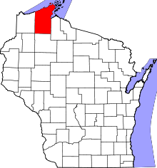 | |
| Village | ||
| Towns | ||
| CDPs | ||
| Unincorporated communities | ||
| Indian reservation | ||
| Footnotes | ‡This populated place also has portions in an adjacent county or counties | |
This article is issued from Wikipedia - version of the 10/22/2016. The text is available under the Creative Commons Attribution/Share Alike but additional terms may apply for the media files.