Grappes Bluff, Louisiana
| Grappes Bluff | |
|---|---|
| Unincorporated community | |
 Grappes Bluff | |
| Coordinates: 31°54′57″N 93°12′16″W / 31.91583°N 93.20444°WCoordinates: 31°54′57″N 93°12′16″W / 31.91583°N 93.20444°W[1] | |
| Country | United States |
| States | Louisiana |
| Parish | Natchitoches |
| Elevation[1] | 154 ft (47 m) |
| Time zone | Central (CST) (UTC-6) |
| • Summer (DST) | CDT (UTC-5) |
| GNIS feature ID | 554588[1] |
Grappes Bluff is an unincorporated community in Natchitoches Parish, Louisiana, United States.[1] It was located nearby Louisiana 480.
References
- 1 2 3 4 "Grappes Bluff, Louisiana". Geographic Names Information System. United States Geological Survey. Retrieved October 23, 2015.
Municipalities and communities of Natchitoches Parish, Louisiana, United States | ||
|---|---|---|
| City | 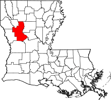 | |
| Town | ||
| Villages | ||
| CDPs | ||
| Other unincorporated communities |
| |
| Footnotes | ‡This populated place also has portions in an adjacent county or counties | |
This article is issued from Wikipedia - version of the 9/30/2016. The text is available under the Creative Commons Attribution/Share Alike but additional terms may apply for the media files.