Great Neck Estates, New York
| Great Neck Estates, New York | |
|---|---|
| Village | |
| Village of Great Neck Estates | |
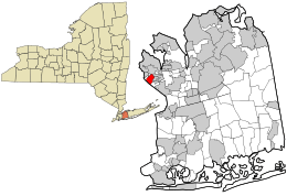 Location in Nassau County and the state of New York. | |
 Great Neck Estates, New York Location within the state of New York | |
| Coordinates: 40°47′14″N 73°44′17″W / 40.78722°N 73.73806°WCoordinates: 40°47′14″N 73°44′17″W / 40.78722°N 73.73806°W | |
| Country | United States |
| State | New York |
| County | Nassau |
| Area | |
| • Total | 0.8 sq mi (2.1 km2) |
| • Land | 0.8 sq mi (2.0 km2) |
| • Water | 0.0 sq mi (0.1 km2) |
| Elevation | 82 ft (25 m) |
| Population (2010) | |
| • Total | 2,761 |
| Time zone | Eastern (EST) (UTC-5) |
| • Summer (DST) | EDT (UTC-4) |
| ZIP code | 11021 |
| Area code(s) | 516 |
| FIPS code | 36-30191 |
| GNIS feature ID | 0951638 |
| Website |
www |
Great Neck Estates is a village and a part of Great Neck in Nassau County, New York in the United States. The population was 2,761 at the 2010 census.
The Great Neck Estates is in the Town of North Hempstead. It is on the Great Neck Peninsula on the North Shore of Long Island, like the other parts of Great Neck.
Geography
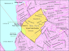
Great Neck Estates is located at 40°47′14″N 73°44′17″W / 40.78722°N 73.73806°W (40.787121, -73.738126).[1]
According to the United States Census Bureau, the village has a total area of 0.8 square miles (2.1 km2), of which, 0.8 square miles (2.1 km2) of it is land and 0.04 square miles (0.10 km2) of it (4.94%) is water.
Demographics
| Historical population | |||
|---|---|---|---|
| Census | Pop. | %± | |
| 1920 | 339 | — | |
| 1930 | 1,738 | 412.7% | |
| 1940 | 1,969 | 13.3% | |
| 1950 | 2,464 | 25.1% | |
| 1960 | 3,262 | 32.4% | |
| 1970 | 3,131 | −4.0% | |
| 1980 | 2,936 | −6.2% | |
| 1990 | 2,790 | −5.0% | |
| 2000 | 2,756 | −1.2% | |
| 2010 | 2,761 | 0.2% | |
| Est. 2015 | 2,827 | [2] | 2.4% |
As of the census[4] of 2000, there were 2,756 people, 919 households, and 767 families residing in the village. The population density was 3,581.3 people per square mile (1,381.9/km²). There were 944 housing units at an average density of 1,226.7 per square mile (473.4/km²). The racial makeup of the village was 92.71% White, 0.94% African American, 4.83% Asian, 0.33% from other races, and 1.20% from two or more races. Hispanic or Latino of any race were 2.61% of the population.
There were 919 households out of which 38.2% had children under the age of 18 living with them, 78.0% were married couples living together, 3.6% had a female householder with no husband present, and 16.5% were non-families. 14.6% of all households were made up of individuals and 9.6% had someone living alone who was 65 years of age or older. The average household size was 3.00 and the average family size was 3.31.
In the village the population was spread out with 26.9% under the age of 18, 5.3% from 18 to 24, 20.9% from 25 to 44, 29.6% from 45 to 64, and 17.3% who were 65 years of age or older. The median age was 43 years. For every 100 females there were 92.9 males. For every 100 females age 18 and over, there were 88.9 males.
The median income for a household in the village was $142,038, and the median income for a family was $161,545. Males had a median income of $100,000 versus $55,938 for females. The per capita income for the village was $72,476. About 1.6% of families and 2.3% of the population were below the poverty line, including 2.4% of those under age 18 and none of those age 65 or over.
References
- ↑ "US Gazetteer files: 2010, 2000, and 1990". United States Census Bureau. 2011-02-12. Retrieved 2011-04-23.
- ↑ "Annual Estimates of the Resident Population for Incorporated Places: April 1, 2010 to July 1, 2015". Retrieved July 2, 2016.
- ↑ "Census of Population and Housing". Census.gov. Retrieved June 4, 2015.
- ↑ "American FactFinder". United States Census Bureau. Retrieved 2008-01-31.