Great Sandy Strait
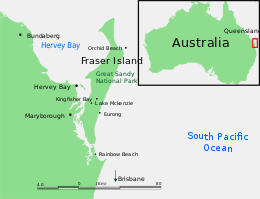
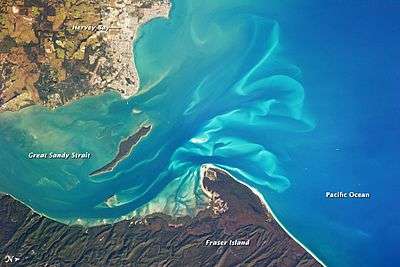
The Great Sandy Strait is a 70 km Australian sand passage estuary separating mainland Queensland, from World Heritage listed Fraser Island.
Description
The strait extends north from Tin Can Bay to Hervey Bay. The Mary River enters the strait at River Heads. It covers an area of 932 km2.[1] Tourism and commercial fishing are the two main industries that are active within the Strait. Boating and fishing are also pursued for recreation.[2] Each year in June the Bay to Bay yacht race is sailed on the Great Sandy Strait.
Environment
A complex landscape of mangroves, sandbanks, intertidal sand, mud islands, salt marshes and seagrass beds, the Strait is an important habitat for breeding fish, crustaceans, dugongs, dolphins and marine turtles. Migrating humpback whales use the calms waters of the strait to rest for a few days between August and November.[3] An analysis of commercial catch data in the area between 1988 and 2003 revealed a significant reduction in fish stock.[4] The campaign against the Traveston Crossing Dam included claims the dam would have a significant environmental impact on the Great Sandy Strait.[5] Other protected areas within or adjacent to the Strait include Great Sandy National Park, Poona National Park and Great Sandy Conservation Park.
Birds
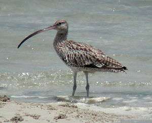
The lower part of Great Sandy Strait was listed under the Ramsar Convention as a wetland of international significance in 1999. The area is also an important roosting site for CAMBA and JAMBA listed species. Some 806 km2 of the strait has been identified by BirdLife International as an Important Bird Area because it supports about 120,000 non-breeding waders, including over 1% of the global populations of bar-tailed godwits, eastern curlews, great knots, grey-tailed tattlers, lesser sand plovers, pied oystercatchers, red-necked stints and red-capped plovers, as well as small numbers of the range-restricted mangrove honeyeater.[6]
See also
- Hinchinbrook Channel
- List of Ramsar sites in Australia
- Pumicestone Passage
- Great Sandy Biosphere Reserve
References
- ↑ "Great Sandy Strait (including Great Sandy Strait, Tin Can Bay, and Tin Can Inlet)". Ramsar Sites Database. Wetlands International. 1999. Retrieved 22 January 2011.
- ↑ "Great Sandy Strait". Queensland Holidays. Tourism Queensland. Retrieved 22 January 2011.
- ↑ "Great Sandy Strait - Hervey Bay Area, Hervey Bay, QLD, Australia". Australian Heritage Database. Commonwealth of Australia. Retrieved 23 June 2014.
- ↑ "Fishing stocks drop in Great Sandy Strait". ABC News Online. Australian Broadcasting Corporation. 4 November 2005. Retrieved 22 January 2011.
- ↑ Bill Hoffman (14 November 2009). "How the Mary Valley was saved". Sunshine Coast Daily. APN News & Media. Retrieved 22 January 2011.
- ↑ "IBA: Great Sandy Strait". Birdata. Birds Australia. Retrieved 2011-06-29.
External links
| Wikimedia Commons has media related to Great Sandy Strait. |
Coordinates: 25°31′24.22″S 152°56′52.32″E / 25.5233944°S 152.9478667°E