Green Line "B" Branch
GREEN LINE "B" BRANCH
Commonwealth Avenue Line | ||||||||||||||||||||||||||||||||||||||||||||||||||||||||||||||||||||||||||||||||||||||||||||||||||||||||||||||||||||||||||||||||||||||||||||||||||||||||||||||||||||||||||||||||||||||||||||||||||||||||||||||||||||||||||||||||||||||||||||||||||||||||||||||||||||||||||||||||||||||||||||||||||||||||||||||||||||||||||||||||||||||||||||||||||||||||||||||||||||||
|---|---|---|---|---|---|---|---|---|---|---|---|---|---|---|---|---|---|---|---|---|---|---|---|---|---|---|---|---|---|---|---|---|---|---|---|---|---|---|---|---|---|---|---|---|---|---|---|---|---|---|---|---|---|---|---|---|---|---|---|---|---|---|---|---|---|---|---|---|---|---|---|---|---|---|---|---|---|---|---|---|---|---|---|---|---|---|---|---|---|---|---|---|---|---|---|---|---|---|---|---|---|---|---|---|---|---|---|---|---|---|---|---|---|---|---|---|---|---|---|---|---|---|---|---|---|---|---|---|---|---|---|---|---|---|---|---|---|---|---|---|---|---|---|---|---|---|---|---|---|---|---|---|---|---|---|---|---|---|---|---|---|---|---|---|---|---|---|---|---|---|---|---|---|---|---|---|---|---|---|---|---|---|---|---|---|---|---|---|---|---|---|---|---|---|---|---|---|---|---|---|---|---|---|---|---|---|---|---|---|---|---|---|---|---|---|---|---|---|---|---|---|---|---|---|---|---|---|---|---|---|---|---|---|---|---|---|---|---|---|---|---|---|---|---|---|---|---|---|---|---|---|---|---|---|---|---|---|---|---|---|---|---|---|---|---|---|---|---|---|---|---|---|---|---|---|---|---|---|---|---|---|---|---|---|---|---|---|---|---|---|---|---|---|---|---|---|---|---|---|---|---|---|---|---|---|---|---|---|---|---|---|---|---|---|---|---|---|---|---|---|---|---|---|---|---|---|---|---|---|---|---|---|---|---|---|---|---|---|---|---|---|---|---|---|---|---|---|---|---|---|---|---|---|---|---|---|---|---|
|
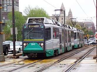
AnsaldoBreda Type 8 #3840 waits at a red light on Commonwealth Avenue at Carlton Street. | ||||||||||||||||||||||||||||||||||||||||||||||||||||||||||||||||||||||||||||||||||||||||||||||||||||||||||||||||||||||||||||||||||||||||||||||||||||||||||||||||||||||||||||||||||||||||||||||||||||||||||||||||||||||||||||||||||||||||||||||||||||||||||||||||||||||||||||||||||||||||||||||||||||||||||||||||||||||||||||||||||||||||||||||||||||||||||||||||||||||
| Overview | ||||||||||||||||||||||||||||||||||||||||||||||||||||||||||||||||||||||||||||||||||||||||||||||||||||||||||||||||||||||||||||||||||||||||||||||||||||||||||||||||||||||||||||||||||||||||||||||||||||||||||||||||||||||||||||||||||||||||||||||||||||||||||||||||||||||||||||||||||||||||||||||||||||||||||||||||||||||||||||||||||||||||||||||||||||||||||||||||||||||
| Type | Light rail | |||||||||||||||||||||||||||||||||||||||||||||||||||||||||||||||||||||||||||||||||||||||||||||||||||||||||||||||||||||||||||||||||||||||||||||||||||||||||||||||||||||||||||||||||||||||||||||||||||||||||||||||||||||||||||||||||||||||||||||||||||||||||||||||||||||||||||||||||||||||||||||||||||||||||||||||||||||||||||||||||||||||||||||||||||||||||||||||||||||
| System | Green Line | |||||||||||||||||||||||||||||||||||||||||||||||||||||||||||||||||||||||||||||||||||||||||||||||||||||||||||||||||||||||||||||||||||||||||||||||||||||||||||||||||||||||||||||||||||||||||||||||||||||||||||||||||||||||||||||||||||||||||||||||||||||||||||||||||||||||||||||||||||||||||||||||||||||||||||||||||||||||||||||||||||||||||||||||||||||||||||||||||||||
| Locale | Greater Boston | |||||||||||||||||||||||||||||||||||||||||||||||||||||||||||||||||||||||||||||||||||||||||||||||||||||||||||||||||||||||||||||||||||||||||||||||||||||||||||||||||||||||||||||||||||||||||||||||||||||||||||||||||||||||||||||||||||||||||||||||||||||||||||||||||||||||||||||||||||||||||||||||||||||||||||||||||||||||||||||||||||||||||||||||||||||||||||||||||||||
| Termini |
Park Street Boston College | |||||||||||||||||||||||||||||||||||||||||||||||||||||||||||||||||||||||||||||||||||||||||||||||||||||||||||||||||||||||||||||||||||||||||||||||||||||||||||||||||||||||||||||||||||||||||||||||||||||||||||||||||||||||||||||||||||||||||||||||||||||||||||||||||||||||||||||||||||||||||||||||||||||||||||||||||||||||||||||||||||||||||||||||||||||||||||||||||||||
| Stations | 25 | |||||||||||||||||||||||||||||||||||||||||||||||||||||||||||||||||||||||||||||||||||||||||||||||||||||||||||||||||||||||||||||||||||||||||||||||||||||||||||||||||||||||||||||||||||||||||||||||||||||||||||||||||||||||||||||||||||||||||||||||||||||||||||||||||||||||||||||||||||||||||||||||||||||||||||||||||||||||||||||||||||||||||||||||||||||||||||||||||||||
| Daily ridership | 26,310 (weekday average boardings from surface stops only in 2010-2011)[1] | |||||||||||||||||||||||||||||||||||||||||||||||||||||||||||||||||||||||||||||||||||||||||||||||||||||||||||||||||||||||||||||||||||||||||||||||||||||||||||||||||||||||||||||||||||||||||||||||||||||||||||||||||||||||||||||||||||||||||||||||||||||||||||||||||||||||||||||||||||||||||||||||||||||||||||||||||||||||||||||||||||||||||||||||||||||||||||||||||||||
| Operation | ||||||||||||||||||||||||||||||||||||||||||||||||||||||||||||||||||||||||||||||||||||||||||||||||||||||||||||||||||||||||||||||||||||||||||||||||||||||||||||||||||||||||||||||||||||||||||||||||||||||||||||||||||||||||||||||||||||||||||||||||||||||||||||||||||||||||||||||||||||||||||||||||||||||||||||||||||||||||||||||||||||||||||||||||||||||||||||||||||||||
| Opened |
1894 (Kenmore to Cottage Farm Bridge) 1895 (Cottage Farm Bridge to Packards Corner) 1896 (Lake Street to Chestnut Hill Avenue) 1900 (Packards Corner to Chestnut Hill Avenue)[2] | |||||||||||||||||||||||||||||||||||||||||||||||||||||||||||||||||||||||||||||||||||||||||||||||||||||||||||||||||||||||||||||||||||||||||||||||||||||||||||||||||||||||||||||||||||||||||||||||||||||||||||||||||||||||||||||||||||||||||||||||||||||||||||||||||||||||||||||||||||||||||||||||||||||||||||||||||||||||||||||||||||||||||||||||||||||||||||||||||||||
| Owner | MBTA | |||||||||||||||||||||||||||||||||||||||||||||||||||||||||||||||||||||||||||||||||||||||||||||||||||||||||||||||||||||||||||||||||||||||||||||||||||||||||||||||||||||||||||||||||||||||||||||||||||||||||||||||||||||||||||||||||||||||||||||||||||||||||||||||||||||||||||||||||||||||||||||||||||||||||||||||||||||||||||||||||||||||||||||||||||||||||||||||||||||
| Operator(s) | MBTA | |||||||||||||||||||||||||||||||||||||||||||||||||||||||||||||||||||||||||||||||||||||||||||||||||||||||||||||||||||||||||||||||||||||||||||||||||||||||||||||||||||||||||||||||||||||||||||||||||||||||||||||||||||||||||||||||||||||||||||||||||||||||||||||||||||||||||||||||||||||||||||||||||||||||||||||||||||||||||||||||||||||||||||||||||||||||||||||||||||||
| Character |
Underground (Kenmore and eastward) Center median running (west of Kenmore) | |||||||||||||||||||||||||||||||||||||||||||||||||||||||||||||||||||||||||||||||||||||||||||||||||||||||||||||||||||||||||||||||||||||||||||||||||||||||||||||||||||||||||||||||||||||||||||||||||||||||||||||||||||||||||||||||||||||||||||||||||||||||||||||||||||||||||||||||||||||||||||||||||||||||||||||||||||||||||||||||||||||||||||||||||||||||||||||||||||||
| Rolling stock |
Kinki Sharyo Type 7 Ansaldobreda Type 8 | |||||||||||||||||||||||||||||||||||||||||||||||||||||||||||||||||||||||||||||||||||||||||||||||||||||||||||||||||||||||||||||||||||||||||||||||||||||||||||||||||||||||||||||||||||||||||||||||||||||||||||||||||||||||||||||||||||||||||||||||||||||||||||||||||||||||||||||||||||||||||||||||||||||||||||||||||||||||||||||||||||||||||||||||||||||||||||||||||||||
| Technical | ||||||||||||||||||||||||||||||||||||||||||||||||||||||||||||||||||||||||||||||||||||||||||||||||||||||||||||||||||||||||||||||||||||||||||||||||||||||||||||||||||||||||||||||||||||||||||||||||||||||||||||||||||||||||||||||||||||||||||||||||||||||||||||||||||||||||||||||||||||||||||||||||||||||||||||||||||||||||||||||||||||||||||||||||||||||||||||||||||||||
| Track gauge | 4 ft 8 1⁄2 in (1,435 mm) | |||||||||||||||||||||||||||||||||||||||||||||||||||||||||||||||||||||||||||||||||||||||||||||||||||||||||||||||||||||||||||||||||||||||||||||||||||||||||||||||||||||||||||||||||||||||||||||||||||||||||||||||||||||||||||||||||||||||||||||||||||||||||||||||||||||||||||||||||||||||||||||||||||||||||||||||||||||||||||||||||||||||||||||||||||||||||||||||||||||
| ||||||||||||||||||||||||||||||||||||||||||||||||||||||||||||||||||||||||||||||||||||||||||||||||||||||||||||||||||||||||||||||||||||||||||||||||||||||||||||||||||||||||||||||||||||||||||||||||||||||||||||||||||||||||||||||||||||||||||||||||||||||||||||||||||||||||||||||||||||||||||||||||||||||||||||||||||||||||||||||||||||||||||||||||||||||||||||||||||||||
The "B" Branch, also called the Commonwealth Avenue Branch or Boston College Branch, is a branch of the MBTA Green Line light rail system which operates on Commonwealth Avenue west of downtown Boston, Massachusetts. One of four branches of the Green Line, the "B" Branch runs from Boston College station down the median of Commonwealth Avenue to Blandford Street. There, it enters Blandford Street Portal into Kenmore station, where it merges with the "C" and "D" branches. The combined services run into the Boylston Street Subway and Tremont Street Subway to downtown Boston. As of 2016, "B" Branch service terminates at Park Street.
The Green Line Rivalry between Boston College and Boston University is named in reference to the "B" Branch, which runs to both universities.
History
In 1896, tracks were laid on Commonwealth Avenue from Chestnut Hill Avenue west to the Newton town line at Lake Street, and around the same time the Commonwealth Avenue Street Railway opened, extending the tracks through Newton to Norumbega Park; this later became part of the Middlesex and Boston Street Railway. Trains between Lake Street and downtown Boston used tracks on Beacon Street, now part of the "C" Branch. From Kenmore Square they continued east on Beacon Street, then turned south on Massachusetts Avenue and east on Boylston Street to Park Square. In 1900 tracks were installed on the rest of Commonwealth Avenue, from Chestnut Hill Avenue east to existing tracks at Packard's Corner, later part of the "A" Branch. This enabled trains to use Commonwealth Avenue between Lake Street and Kenmore Square. In 1909, the tracks were electrified.[3]
The Tremont Street Subway opened on September 1, 1897 and then or soon after the Commonwealth Avenue line was rerouted to turn around at Park Street via the Boylston Street Incline at the Public Garden. The Boylston Street Subway opened on October 3, 1914, extending the underground portion to the Kenmore Incline just east of Kenmore Square. On October 23, 1932 the Blandford Street Incline opened along with the underground Kenmore station, giving the line its present configuration.
Until the 1920s, a streetcar line that has since become the 65 bus ran along Commonwealth Avenue from Boston College east to Chestnut Hill Avenue, then south on Chestnut Hill Avenue and east on Beacon Street from Cleveland Circle to Washington Square, turning southeast to Brookline Village. After this was replaced by bus service in the 1920s (along with a rerouting), no revenue service used the tracks on Chestnut Hill Avenue, but they have remained for "B" Branch trains to access the Reservoir Carhouse at Cleveland Circle on the "C" Branch.
A turnback loop at Boston University Field was present from 1915 to January 14, 1962. It was used for service to special events as well as to short-turn some rush hour trains.
From 1942 to 1967, the route was known by the map number of 62. In 1967, the lines were given colors and the Green Line branches were lettered. The Commonwealth Avenue Line became the "B" Branch.
Downtown terminal
Until 1931, the line always looped at Park Street. On February 7 of that year, the Commonwealth Avenue service was extended east through downtown to loop at Lechmere. Since then, the following changes in east terminal have been made:[4]
- November 20, 1961: cut back to Park Street
- November 18, 1964: extended Monday-Saturday to Government Center
- January 1967: cut back to Park Street all times due to problems at the Government Center loop
- March 25, 1967: extended to North Station
- June 17, 1967: cut back to Government Center
- September 9, 1967: extended to North Station
- September 14, 1967: cut back to Government Center due to problems at the North Station loop
- March 21, 1970: extended to Haymarket, looped empty at North Station
- December 26, 1970: extended to North Station
- March 25, 1974: extended to Lechmere
- January 1, 1977: cut back to North Station weekdays only
- March 19, 1977: extended to Lechmere all times
- June 18, 1977: cut back to Government Center all times
- September 9, 1977: extended to Lechmere all times
- September 9, 1978: cut back to Government Center nights and Sundays
- March 24, 1979: cut back to Government Center middays and Saturdays, with only rush hour trips continuing to Lechmere
- March 21, 1980: cut back to Park Street all times
- April 4, 1981: extended to North Station (PCC cars looped at Government Center)
- July 30, 1983: cut back to Government Center
- June 25, 2004: extended to North Station
- January 1, 2005: cut back to Government Center
- March 22, 2014: cut back to Park Street due to Government Center closure; the branch terminus stayed at Park Street when the station was reopened in 2016
Stop consolidation
The "B" Branch is frequently criticized by riders for its slow service, which is largely a result of a high number of stops and level crossings. The line has 27 level crossings and 18 stops on the surface section.
In late 2003, the MBTA proposed eliminating five surface stops (Greycliff Road, Chiswick Road, Mount Hood Road, Summit Avenue, and Fordham Road) as part of a project to improve the line. The five stops were chosen because they had low ridership and were located very close to other stations.[5] No stops east of Packards Corner were chosen, although they would affect the largest number of riders; despite their close spacing, they have higher ridership, and their proximity to traffic lights lowers the travel time savings from elimination. After a public comment period, Chiswick Road was removed from the proposal, as it serves a nearby elderly housing community.[5] On April 20, 2004, the other four stops were closed as a 6-to-8-month pilot program.[6] On March 15, 2005, after a survey showed that 73% of 1,142 riders surveyed approved of the closures, the MBTA board voted to make the closures permanent.[5]
In October 2014, the MBTA began holding meetings for a proposal to consolidate four stops - Boston University West, St. Paul Street, Pleasant Street, and Babcock Street - located near Boston University's West Campus. The four stops, which are not handicapped-accessible, would be turned into two fully accessible stops as part of a planned redesign of Commonwealth Avenue between the BU Bridge and Packard's Corner.[7][8]
Station listing
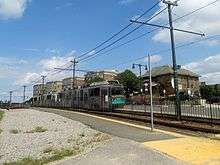
Trains on the "B" Branch only travel from Park Street to Boston College. The segment from Park Street to Kenmore is shared with the three other branches. There is no MBTA parking at any "B" Branch stations.


| Station | Location | Transfers and notes |
|---|---|---|
| Blandford Street | Commonwealth Avenue at Silber Way, Boston | MBTA Bus: 57 |
| Commonwealth Avenue at Granby Street, Boston | MBTA Bus: 57 | |
| Commonwealth Avenue at Marsh Chapel, Boston | MBTA Bus: 57 | |
| Boston University West | Commonwealth Avenue at Amory Street, Boston | MBTA Bus: 57 |
| St. Paul Street | Commonwealth Avenue at Buick Street, Boston | MBTA Bus: 57 |
| Pleasant Street | Commonwealth Avenue at Pleasant Street, Boston | MBTA Bus: 57 |
| Babcock Street | Commonwealth Avenue at Babcock Street, Boston | MBTA Bus: 57 |
| Packards Corner | Commonwealth Avenue at Brighton Avenue, Allston | MBTA Bus: 57 |
| Fordham Road | Commonwealth Avenue at Fordham Road, Allston | Closed in 2004 |
| Commonwealth Avenue at Harvard Avenue, Allston | MBTA Bus: 66 | |
| Griggs Street/Long Avenue | Commonwealth Avenue at Griggs Street, Allston | |
| Allston Street | Commonwealth Avenue at Allston Street, Allston | |
| Warren Street | Commonwealth Avenue at Warren Street, Brighton | |
| Summit Avenue | Commonwealth Avenue at Summit Avenue, Brighton | Closed in 2004 |
| Commonwealth Avenue at Washington Street, Brighton | MBTA Bus: 65 | |
| Mount Hood Road | Commonwealth Avenue at Mount Hood Road, Brighton | Closed in 2004 |
| Sutherland Road | Commonwealth Avenue at Sutherland Road, Brighton | |
| Chiswick Road | Commonwealth Avenue at Chiswick Road, Brighton | |
| Chestnut Hill Avenue | Commonwealth Avenue at Chestnut Hill Avenue, Brighton | MBTA Bus: 86 |
| South Street | Commonwealth Avenue at South Street, Brighton | |
| Greycliff Road | Commonwealth Avenue at Greycliff Road, Brighton | Closed in 2004 |
| Commonwealth Avenue at Lake Street, Chestnut Hill, Boston |
References
- ↑ "Ridership and Service Statistics" (PDF) (14 ed.). Massachusetts Bay Transportation Authority. 2014. Retrieved 1 September 2016.
- ↑ Engineering and Maintenance Department (1981). "History of subways, tunnels and elevated lines". Massachusetts Bay Transportation Authority. Retrieved 1 September 2016.
- ↑ "Cleveland Circle History". Brighton Allston Historical Society. Retrieved 27 August 2014.
- ↑ Belcher, Jonathan (22 March 2014). "Changes to Transit Service in the MBTA district" (PDF). NETransit. Retrieved 28 August 2014.
- 1 2 3 Daniel, Mac (16 March 2005). "T drops 4 Green Line stops after results of rider survey". Boston Globe. Archived from the original on 18 March 2005. Retrieved 6 February 2014.
- ↑ "Green Line B Branch Service Enhancements" (PDF). TRANSreport. Boston Regional Metropolitan Planning Organization. May 2004. Archived from the original (PDF) on 16 January 2011. Retrieved 6 February 2014.
- ↑ "Comm. Ave. Green Line Improvements Public Meeting". Massachusetts Bay Transportation Authority. Massachusetts Bay Transportation Authority. Retrieved 2014-10-30.
- ↑ O'Rourke, John (23 October 2014). "T May Eliminate Two Green Line B Stops". BU Today. Retrieved 31 October 2014.
External links
| Wikimedia Commons has media related to Green Line "B" Branch. |
<div class="kmldata" data-server="en.wikipedia.org" title="Template:Attached KML/Green Line "B" Branch" style="display:none;">Template:Attached KML/Green Line "B" Branch
| Subway lines (List of stations) |
| |||||||||||
|---|---|---|---|---|---|---|---|---|---|---|---|---|
| Commuter Rail lines (List of stations) |
| |||||||||||
| Bus routes (List of routes) | ||||||||||||
| Other services | ||||||||||||
| Component parts of system lines | ||||||||||||
| Capital projects |
| |||||||||||
| History |
| |||||||||||
| Other | ||||||||||||