Greene Township, Greene County, Pennsylvania
| Greene Township | |
|---|---|
| Township | |
|
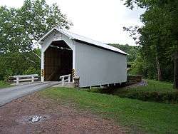
White Covered Bridge (1919) National Register of Historic Places | |
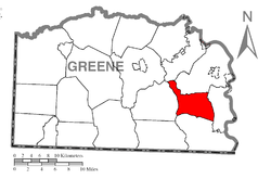 Location of Greene Township in Greene County | |
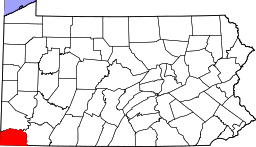 Location of Greene County in Pennsylvania | |
| Country | United States |
| State | Pennsylvania |
| County | Greene |
| Area | |
| • Total | 18.6 sq mi (48 km2) |
| Population (2010) | |
| • Total | 445 |
| • Density | 24/sq mi (9.2/km2) |
| Time zone | EST (UTC-4) |
| • Summer (DST) | EDT (UTC-5) |
| Area code(s) | 724 |
Greene Township is a township in Greene County, Pennsylvania, United States. The population was 445 at the 2010 census.
History
The John Corbley Farm, Neils Red Covered Bridge, and White Covered Bridge are listed on the National Register of Historic Places.[1]
Geography
According to the United States Census Bureau, the township has a total area of 18.6 square miles (48 km2), all of it land.
Demographics
As of the census[2] of 2010 Profile of General Population and Housing Characteristics: 2010, U. S. Census Bureau 2010 Demographic Profile Data, there were 445 people, 180 households, and 142 families residing in the township. The population density was 23.9 people per square mile (9.2/km²). There were 203 housing units at an average density of 10.9/sq mi (4.2/km²). The racial makeup of the township was 98.20% White, 0.22% African American, 0.45% Native American, 0.22% Asian, and 0.90% from two or more races. Hispanic or Latino of any race were 0.67% of the population.
There were 180 households, out of which 30.0% had children under the age of 18 living with them, 61.7% were married couples living together, 10.0% had a female householder with no husband present, and 21.1% were non-families. 18.3% of all households were made up of individuals, and 10.0% had someone living alone who was 65 years of age or older. The average household size was 2.47 and the average family size was 2.71.
In the township the population was spread out, with 22.2% under the age of 18, 6.3% from 18 to 24, 26.7% from 25 to 44, 28.5% from 45 to 64, and 16.2% who were 65 years of age or older. The median age was 43 years. For every 100 females there were 96.0 males. For every 100 females age 18 and over, there were 95.5 males.
The median income for a household in the township was $30,227, and the median income for a family was $31,806. Males had a median income of $25,781 versus $18,929 for females. The per capita income for the township was $15,486. About 5.7% of families and 9.8% of the population were below the poverty line, including 12.3% of those under age 18 and 11.5% of those age 65 or over.
References
- ↑ National Park Service (2010-07-09). "National Register Information System". National Register of Historic Places. National Park Service.
- ↑ "American FactFinder". United States Census Bureau. Retrieved 2016-08-19.
Municipalities and communities of Greene County, Pennsylvania, United States | ||
|---|---|---|
| Boroughs | | |
| Townships | ||
| CDPs | ||
| Unincorporated communities | ||
Coordinates: 39°50′00″N 79°59′29″W / 39.83333°N 79.99139°W